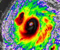
Yep. Polo is not done. That big eye is getting really round now.
Follow along with the video below to see how to install our site as a web app on your home screen.
Note: This feature may not be available in some browsers.

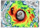

if the eye can peak, this peak is probably gonna be 140-145 kts.View attachment 55057
Here we go again. Eye’s pretty much fully cleared again, much bigger this time around, and it’s getting that symmetric look. We’re going to see another breach into C5 shortly. I don’t think the pressure will go sub-900 again though.
000
WTPZ62 KNHC 240042
TCUEP2

Hurricane Polo Tropical Cyclone Update
NWS National Hurricane Center Miami FL       EP172026
640 PM CST Wed Sep 23 2026

...POLO HAS RESTRENGTHENED INTO A CATEGORY 5 HURRICANE...

Recent satellite intensity estimates indicate that Polo has quickly
strengthened into a Category 5 hurricane with estimated maximum
sustained winds of 160 mph (260 km/h). This intensity change will be
reflected in the next routine forecast advisory package that will be
issued by 900 PM CST (0300 UTC).

SUMMARY OF 640 PM CST...0040 UTC...INFORMATION
---------------------------------------------------
LOCATION...15.8N 102.3W
ABOUT 145 MI...235 KM SSW OF ZIHUATANEJO MEXICO
ABOUT 265 MI...425 KM SSE OF MANZANILLO MEXICO
MAXIMUM SUSTAINED WINDS...160 MPH...260 KM/H
PRESENT MOVEMENT...NW OR 310 DEGREES AT 6 MPH...9 KM/H
MINIMUM CENTRAL PRESSURE...925 MB...27.31 INCHES

$$
Forecaster Reinhart
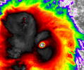
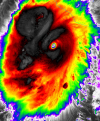
The eye has also shrunk considerably and looks really menacing again, it's probably going to intensify a third time. The blob almost looksSeriously, this is going to need to be studied by some REALLY smart people, because... what?
I'm thinking Fujiwara interaction with the other system out there - looping back, the blob began when the midlevel water vapor from the other system started getting pulled in. Fujiwara may not be the right term here - they aren't directly interacting, but Polo is "downstream".The eye has also shrunk considerably and looks really menacing again, it's probably going to intensify a third time. The blob almost looksanticyclonic,(see edit) it looks like it has an eye of some kind... Normally these blobs in TCs are located to the east or northeast of the COC, so this is really unusual for sure. I wonder if there are any other examples of this occurring, because I certainly haven't been watching the weather long enough to know if there has been.
I think we're also about to see another big time blowup of CDO cooling here unless it undergoes some sort of ERC again.
EDIT: Seriously, what the hell is that? It actually looks like another system entirely, there's clearly some sort of eye-like structure there, and I take back that it looks anticyclonic, because I can't tell what direction it is rotating at all (if it is - certainly looks like it).

I'm thinking Fujiwara interaction with the other system out there - looping back, the blob began when the midlevel water vapor from the other system started getting pulled in. Fujiwara may not be the right term here - they aren't directly interacting, but Polo is "downstream".
EDIT - and it may trigger another EWRC. Polo wants to be huge.

Agreed - Fujiwara was the wrong term, but the timing with the arrival of the mid level moisture off Odalys made it pretty obvious that an interaction between the air masses initiated the big blob. The size and the odd yin/yang look is what I had never seen before - blobs with storms aren't unusual.A little too far apart for Fujiwara I think.
This is an incredible storm.

 satlib.cira.colostate.edu
I'm curious - what makes you think that - channeling off the mountains?Think what's causing that blob to the NW of Polo has to do with the terrain of Mexico.