
00z and 12z Euro are giving off TS Erin (07), TS Allison (01), and TS Olga (19) vibes next weekend. Definitely need to keep a close watch on this. Even NWS Jackson brought the Euro scenario up.
Navigation
Install the app
How to install the app on iOS
Follow along with the video below to see how to install our site as a web app on your home screen.
Note: This feature may not be available in some browsers.
More options
-
Welcome to TalkWeather! We see you lurking around TalkWeather! Take the extra step and join us today to view attachments, see less ads and maybe even join the discussion. CLICK TO JOIN TALKWEATHER
You are using an out of date browser. It may not display this or other websites correctly.
You should upgrade or use an alternative browser.
You should upgrade or use an alternative browser.
2026 Atlantic Hurricane Season
- Thread starter Atlantic
- Start date
Euro is remarkably consistent the past several runs on this possible system. NHC has assigned a 30% 7-day development probability as it skirts northeastern Mexico and Texas.00z and 12z Euro are giving off TS Erin (07), TS Allison (01), and TS Olga (19) vibes next weekend. Definitely need to keep a close watch on this. Even NWS Jackson brought the Euro scenario up.
ZCZC MIATWOAT ALL
TTAA00 KNHC DDHHMM
Tropical Weather Outlook
NWS National Hurricane Center Miami FL
200 PM EDT Sun Jun 14 2026
For the North Atlantic...Caribbean Sea and the Gulf of America:
1. Northwestern Gulf of America:
A trough of low pressure located over northeastern Mexico is
producing disorganized shower and thunderstorm activity.
Development is not expected during the next day or so while the
trough remains inland and drifts northward over northeastern Mexico
or southern Texas. The system is then forecast to move northeastward
and could re-emerge over the northwestern Gulf of America late
Tuesday or Wednesday, where environmental conditions may support
some development around midweek. Regardless of formation chances,
heavy rainfall and flash flooding are possible across portions of
eastern and southern Texas and Louisiana this week.
* Formation chance through 48 hours...low...near 0 percent.
* Formation chance through 7 days...low...30 percent.
Forecaster Adams/Blake
Yeah after NHC saying the last few days it wouldn't develop. LOL!Euro is remarkably consistent the past several runs on this possible system. NHC has assigned a 30% 7-day development probability as it skirts northeastern Mexico and Texas.
BamaWX
Member
Looks like we might get Tropical Storm Arthur tomorrow, if it can get its act together quickly enough. Either way, this storm is likely to produce heavy rainfall along the Gulf Coast.
BamaWX
Member
The NHC will issue advisories for Potential Tropical Cyclone One at 10:00 AM CDT.
Kds86z
Member
- Admin
- #27
- Messages
- 2,433
- Reaction score
- 2,273
- Location
- Meridianville, Al
- Special Affiliations
- SKYWARN® Volunteer
NHC watching the SE US coast.
The Google A.I. model is picking this up and having it come ashore late in the week. Didn't see it on the Euro or GFS.
The Google A.I. model is picking this up and having it come ashore late in the week. Didn't see it on the Euro or GFS.
Lemon of the SE Coast.
Off of the southeastern coast of the U. S.:
A low pressure area is expected to form offshore of the southeastern
coast of the United States along the western end of a frontal
system early next week. Slow development of this system will be
possible thereafter while it moves slowly westward.
* Formation chance through 48 hours...low...near 0 percent.
* Formation chance through 7 days...low...20 percent
akt1985
Member
That potential system off the Southeast U.S. might spell disaster for those at the beach July 4th Weekend and rip currents.
Ensembles are picking up on a system near the Gulf by the weekend or early next week.
akt1985
Member
That system has been dropped by the models.Ensembles are picking up on a system near the Gulf by the weekend or early next week.
Area of interest has been outlined now in the northeastern gulf
We've also got an area coming off the West African coast they're watching.Area of interest has been outlined now in the northeastern gulf
ZCZC MIATWOAT ALL
TTAA00 KNHC DDHHMM
Tropical Weather Outlook
NWS National Hurricane Center Miami FL
200 PM EDT Wed Jul 15 2026
For the North Atlantic...Caribbean Sea and the Gulf of America:
1. Northeastern Gulf of America:
An area of low pressure is expected to form during the weekend over
the northeastern Gulf of America. Subsequent slow development of
this system is possible while it moves slowly northeastward over the
northeastern Gulf and or near the southeastern coast of the United
States by early next week.
* Formation chance through 48 hours...low...near 0 percent.
* Formation chance through 7 days...low...20 percent.
2. Eastern Tropical Atlantic:
Showers and thunderstorms associated with a tropical wave southeast
of the Cabo Verde Islands have become a little better organized
during the past 24 hours. Some additional slow development is
possible over the next couple of days as the system moves generally
west-northwestward. After that, the system is expected to move into
an environment that is not conducive for additional development by
the weekend.
* Formation chance through 48 hours...low...10 percent.
* Formation chance through 7 days...low...10 percent.
Forecaster Beven

MattW
Member
- Messages
- 388
- Reaction score
- 382
- Location
- Decatur, GA
- HAM Callsign
- KG4GUF
- Special Affiliations
- SKYWARN® Volunteer

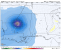
Interesting NAM output for the weekend. I'm guessing just a tropical storm, and yes, I know the NAM can overdo things.
Dont think that's out of the question of happening. Bring it on! Feeder band tornadoes in Florida!View attachment 54162
Interesting NAM output for the weekend. I'm guessing just a tropical storm, and yes, I know the NAM can overdo things.
Hrrr is gung ho to the max on a tropical low lol.
Area being monitored by NHC in NE Gulf should be of no surprise. I set this up back on July 10th (which I shared on here last Saturday: https://talkweather.com/threads/2026-global-tropical-cyclone-discussion.2470/post-211103)
You could see this clearly beginning with Super Typhoon Bavi and now with the Eastern Pacific activity. MJO
You could see this clearly beginning with Super Typhoon Bavi and now with the Eastern Pacific activity. MJO
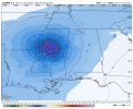
Hrrr shows a tropical storm. Maybe even a shot at a cat1. Landfall in Florida
BamaWX
Member
Wow! I didn't expect to see such an organised storm off the coast of Florida.

Wow!!!! Good grief, looks like a tropical storm already