
Navigation
Install the app
How to install the app on iOS
Follow along with the video below to see how to install our site as a web app on your home screen.
Note: This feature may not be available in some browsers.
More options
-
Welcome to TalkWeather! We see you lurking around TalkWeather! Take the extra step and join us today to view attachments, see less ads and maybe even join the discussion. CLICK TO JOIN TALKWEATHER
You are using an out of date browser. It may not display this or other websites correctly.
You should upgrade or use an alternative browser.
You should upgrade or use an alternative browser.
Severe WX 2/5/2020-2/6/2020 Severe Weather
- Thread starter Kory
- Start date
- Thread starter
- #62
Kory
Member
I’m thinking more SW to NE where some of the rain cooled air from the showers this morning and early afternoon were. Looks like one from South of Jackson NE to Meridian and just north of 20/59. Potentially another one where the Yazoo City storm is going to town and NE of there up in the vicinity of GWX. And potentially the warm front up in NE MS into the Shoals.I'm not very good at boundary identification. So, this boundary runs N/NW to S/SE in a line approximately from Yazoo City to Mobile (give or take a little)?
this is just me observing sort of the “train tracks” these cells are on.
Bama Ravens
Member
Confirmed large and extremely dangerous tornado approaching Pickens, MS.
A couple of confirmed tornadoes in NWS JAN's area now:
And:
Leake MS-Holmes MS-Attala MS-Madison MS-
404 PM CST Wed Feb 5 2020
...A TORNADO WARNING REMAINS IN EFFECT UNTIL 500 PM CST FOR NORTHERN
LEAKE...SOUTHEASTERN HOLMES...ATTALA AND NORTHEASTERN MADISON
COUNTIES...
At 404 PM CST, a confirmed large and extremely dangerous tornado was
located over Pickens, or 16 miles southwest of Durant, moving
northeast at 50 mph.
This is a PARTICULARLY DANGEROUS SITUATION. TAKE COVER NOW!
HAZARD...Damaging tornado.
SOURCE...Radar confirmed tornado.
And:
Yazoo MS-
403 PM CST Wed Feb 5 2020
...A TORNADO WARNING REMAINS IN EFFECT UNTIL 415 PM CST FOR
NORTHEASTERN YAZOO COUNTY...
At 402 PM CST, a confirmed large and extremely dangerous tornado was
located near Vaughan, or 16 miles north of Canton, moving east at 45
mph.
This is a PARTICULARLY DANGEROUS SITUATION. TAKE COVER NOW!
HAZARD...Damaging tornado.
SOURCE...Radar confirmed tornado.
CheeselandSkies
Member
TORR'd as "radar confirmed," but I don't really see a clear TDS on KDGX as of 2202 UTC. There is definitely a pronounced couplet approaching Pickens, though.
Last edited:
- Thread starter
- #66
Kory
Member
That storm has just been marching across MS. Pretty crazy.
bwalk
Member
That storm has just been marching across MS. Pretty crazy.
And based on the storm tracks, Vernon and Hamilton, Al. need to be watching this particular long-tracking storm.
- Moderator
- #68
Been watching the sky for the past couple hours and the low level clouds have definitely picked up the pace here in Madison County, AL. Not seeing low level sheer mixing the convection like you sometimes can but there's been a pretty thick cloud layer obstructing view of the mid levels.
Chris3024
Member
Tishomingo looks to be spinning up
Chris3024
Member
Tornado Warning Colbert Co.
warneagle
Member
Impressive rotation near Tishomingo
cheestaysfly
Member
Hoping for the best here in Florence. 
KruedVoice13
Member
Just curious what the outlook for central Georgia is. I used to live in Bama and got all my weather information from here.
Bama Ravens
Member
So do we think the storms over south AL/along the Gulf Coast have helped those of us in the northern half of AL?
Bama Ravens
Member
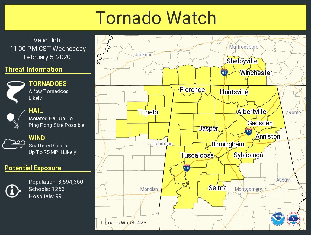
Also, this is the latest watch that was issued about 4:30pm CST.
- Thread starter
- #76
Kory
Member
They most certainly have.So do we think the storms over south AL/along the Gulf Coast have helped those of us in the northern half of AL?
Bama Ravens
Member
I guess MS hasn’t gotten as much help from them, hence the warned storms still ongoing there.They most certainly have.
- Thread starter
- #78
Kory
Member
Don't be shocked to see that make their way into Western and NW AL still. We're downstream from that more "untapped" atmosphere.I guess MS hasn’t gotten as much help from them, hence the warned storms still ongoing there.
Justin Hindman
Member
- Messages
- 378
- Reaction score
- 1,165
- Location
- Gardendale Alabama
- Special Affiliations
- SKYWARN® Volunteer
- ARRL Member
I continue to see a smaller risk for Alabama like I had thought yesterday. Lot of rain south. Just watch the storms for brief spin ups imo. I think East of 65 the threat is real slim from Birmingham eastward
- Staff
- #80
Looks like things are getting jiggy in TN!!