• Welcome to TalkWeather!
    We see you lurking around TalkWeather! Take the extra step and join us today to view attachments, see less ads and maybe even join the discussion.
    CLICK TO JOIN TALKWEATHER
Logo 468x120

Severe WX 2/5/2020-2/6/2020 Severe Weather

Kory

Member
Messages
4,928
Reaction score
2,119
Location
Tuscaloosa, Alabama
A lot of messy convection along the MS & AL coasts, and into FL panhandle. Wonder how that might impact things.
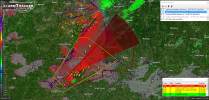
It is sure taking a chunk out of the warm sector it seems for this afternoon. But, as stated before, this is a long duration event into the overnight hours. Once that scoots east, there may not be much to abate things after dark.
 
Messages
2,753
Reaction score
4,291
Location
Madison, WI
The cells popping up in LA certainly have "the look" (of potential tornadic supercells, that is). If they can become rooted in the boundary layer for any length of time, look out.
 

bwalk

Member
Messages
597
Reaction score
291
Location
Prattville, Al
So now we have school closings in the B'ham area. It seems like the new mindset is a Tornado WATCH justifies school closings. I'm not sure that is a good policy. Yes, I agree, 'better safe than sorry', but how far do you take it? Maybe there are other reasons for the closings - flooding?

1580929341644.png
 

almays1

Member
Messages
6
Reaction score
9
Location
Tuscaloosa, AL
So now we have school closings in the B'ham area. It seems like the new mindset is a Tornado WATCH justifies school closings. I'm not sure that is a good policy. Yes, I agree, 'better safe than sorry', but how far do you take it? Maybe there are other reasons for the closings - flooding?

View attachment 2458
School buses are high-profile vehicles and are not recommended to be on roads when winds exceed 35 MPH. Some counties are very large as well, so getting all of the kids home safely can take over 2 hours.
 

NorthBamaWX

Member
Messages
197
Reaction score
55
Location
Athens Alabama
BULLETIN - EAS ACTIVATION REQUESTED
Tornado Warning
National Weather Service Jackson MS
207 PM CST Wed Feb 5 2020

The National Weather Service in Jackson has issued a

* Tornado Warning for...
Southeastern Rankin County in central Mississippi...
Simpson County in central Mississippi...
Northeastern Lincoln County in south central Mississippi...
Northern Lawrence County in south central Mississippi...
Southeastern Copiah County in central Mississippi...

* Until 300 PM CST.

* At 207 PM CST, a severe thunderstorm capable of producing a tornado
was located near Sontag, or 13 miles northeast of Brookhaven,
moving northeast at 45 mph.

HAZARD...Tornado and golf ball size hail.

SOURCE...Radar indicated rotation.

IMPACT...Flying debris will be dangerous to those caught without
shelter. Mobile homes will be damaged or destroyed.
Damage to roofs, windows, and vehicles will occur. Tree
damage is likely.

* This dangerous storm will be near...
Oma around 215 PM CST.
Rockport around 220 PM CST.
Union and Shivers around 230 PM CST.
Pinola around 235 PM CST.
Mendenhall around 245 PM CST.
Magee and Sanatorium around 250 PM CST.
Martinville around 255 PM CST.

Other locations impacted by this tornadic thunderstorm include New
Hebron, D'Lo and Braxton.

PRECAUTIONARY/PREPAREDNESS ACTIONS...

TAKE COVER NOW! Move to a basement or an interior room on the lowest
floor of a sturdy building. Avoid windows. If you are outdoors, in a
mobile home, or in a vehicle, move to the closest substantial shelter
and protect yourself from flying debris.
 

Kory

Member
Messages
4,928
Reaction score
2,119
Location
Tuscaloosa, Alabama
That cell south of Jackson is most certainly riding a boundary. You can see showers firing off to the East along it...
 

bwalk

Member
Messages
597
Reaction score
291
Location
Prattville, Al
School buses are high-profile vehicles and are not recommended to be on roads when winds exceed 35 MPH. Some counties are very large as well, so getting all of the kids home safely can take over 2 hours.

The only problem here is the policy could become, "Every time there is a possibility of winds over 35mph schools should be canceled or let out early."
 

almays1

Member
Messages
6
Reaction score
9
Location
Tuscaloosa, AL
The only problem here is the policy could become, "Every time there is a possibility of winds over 35mph schools should be canceled or let out early."
And...that's why school officials are darned if they do and darned if they don't.
 

bwalk

Member
Messages
597
Reaction score
291
Location
Prattville, Al
And...that's why school officials are darned if they do and darned if they don't.

You are right. This school closing discussion has been going on on this board for many years with no consensus. People basically fall 50/50 on either side of the issue. I guess 'better safe than sorry' is the best policy.
 

Kory

Member
Messages
4,928
Reaction score
2,119
Location
Tuscaloosa, Alabama
Got a few supercells going now across Mississippi. Wind fields will only begin to strengthen over the next several hours into the overnight hours.
 

South AL Wx

Member
Meteorologist
Messages
309
Reaction score
311
Location
Wetumpka, AL
Special Affiliations
  1. SKYWARN® Volunteer
Confirmed tornado in MS:

The National Weather Service in Jackson has issued a

* Tornado Warning for...
Northeastern Simpson County in central Mississippi...
Northern Smith County in central Mississippi...

* Until 400 PM CST.

* At 302 PM CST, a confirmed tornado was located over Martinville, or
8 miles north of Magee, moving northeast at 35 mph.


HAZARD...Damaging tornado and quarter size hail.

SOURCE...Radar confirmed tornado.​
 

Kory

Member
Messages
4,928
Reaction score
2,119
Location
Tuscaloosa, Alabama
Yeah, that cell in Greene Co AL looks suspicious as well. They’re all riding the same boundary. The one SW of the confirmed tor in MS as well.
 

South AL Wx

Member
Meteorologist
Messages
309
Reaction score
311
Location
Wetumpka, AL
Special Affiliations
  1. SKYWARN® Volunteer
mcd0080.gif


Mesoscale Discussion 0080
NWS Storm Prediction Center Norman OK
0347 PM CST Wed Feb 05 2020

Areas affected...Northern and central Alabama

Concerning...Severe potential...Tornado Watch likely

Valid 052147Z - 052345Z

Probability of Watch Issuance...95 percent

SUMMARY...Storms in central Mississippi have increased in intensity
over the last hour. These storms are expected to continue northeast
into central/northern Alabama coincident with an increasingly
favorable environment for severe storms. Tornadoes, with a strong
tornado possible, as well as damaging winds and isolated large hail
will be possible this evening. A tornado watch is likely in the next
hour or two.

DISCUSSION...With the continued approach of a mid-level trough, the
environment within northern and central Alabama should become more
favorable for severe thunderstorms later this afternoon into the
evening. Severe storms are ongoing across central Mississippi and
have been increasing in intensity over the last hour. With time,
mid-level cooling and low-level theta-e advection will help to
increase buoyancy across the region to 1000-1500 J/kg MLCAPE.
Currently, KHTX/KBMX VAD profiles show 250-300 m2/s2 0-1 km SRH.
With an increase in 850 mb flow this evening, low-level hodographs
only improve with time. As storms in Mississippi continue northeast,
they will continue to pose a threat for a few tornadoes, some
potentially strong. Damaging wind gusts and isolated large hail are
possible. A tornado watch will be needed in the next 1-2 hours.​
 

bwalk

Member
Messages
597
Reaction score
291
Location
Prattville, Al
Yeah, that cell in Greene Co AL looks suspicious as well. They’re all riding the same boundary. The one SW of the confirmed tor in MS as well.

I'm not very good at boundary identification. So, this boundary runs N/NW to S/SE in a line approximately from Yazoo City to Mobile (give or take a little)?
 
Back
Top