• Welcome to TalkWeather!
    We see you lurking around TalkWeather! Take the extra step and join us today to view attachments, see less ads and maybe even join the discussion.
    CLICK TO JOIN TALKWEATHER

2/19/26- 2/20/26 - severe threat discussion

Latest day 2


WHILE INSTABILITY WILL REMAIN MODEST OWING TO LIMITED BOUNDARY-LAYER
MOISTURE, CLEARING AHEAD OF A SURGING DRYLINE TIED TO THE SURFACE
LOW WILL ALLOW FOR DIURNAL HEATING. IN COMBINATION WITH STEEPENING
MID-LEVEL LAPSE RATES, AROUND 500-1000 J/KG OF MLCAPE IS EXACTED BY
EARLY AFTERNOON. AN ARC OF MAINLY CELLULAR CONVECTION SHOULD DEVELOP
BY MID AFTERNOON ACROSS FAR EASTERN MO AND WESTERN TO SOUTH-CENTRAL
IL AND MOVE QUICKLY EASTWARD. AMID VERY STRONG KINEMATIC FIELDS
(EBWD 55+ KT) A SUPERCELL MODE IS EXPECTED. STRONG LOW-LEVEL SHEAR
AND THE CONCENTRATION OF BUOYANCY IN THE LOWEST FEW KM WILL FAVOR
STRONG VERTICAL ACCELERATIONS AND STRETCHING WITH SEASONABLY COOL
MID-LEVEL TEMPERATURES. HAIL IS LIKELY WITH THE STRONGER ROTATING
STORMS. ADDITIONALLY, WITH BACKED LOW-LEVEL FLOW NEAR THE LOW/WARM
FRONT AND LARGE LOW-LEVEL SHEAR, (0-1 KM BWD 25+ KT) A FEW TORNADOES
ARE POSSIBLE.

AS ASCENT SPREADS EASTWARD, THUNDERSTORM ACTIVITY MAY EVENTUALLY
GROW UPSCALE ENOUGH TO SUPPORT INCREASING POTENTIAL FOR DAMAGING
WIND GUSTS GIVEN THE STRONG BACKGROUND FLOW. HOWEVER, DECREASING
BUOYANCY AND WEAKENING HEIGHT FALLS WITH EASTWARD EXTENT SHOULD
GRADUALLY LIMIT CONVECTIVE INTENSITY INTO PARTS OF THE MIDDLE OH
VALLEY LATE THURSDAY EVENING.

..LYONS.. 02/18/2026
 
I might just head to northern Illinois (somewhere between the I-88/I-80 corridors, northwest tip of the dark green shading) tomorrow afternoon and hope something overachieves up there. There might well be something good further south, but as so often happens there's just a *bit* too much uncertainty for me to feel like driving that far.
 
I might just head to northern Illinois (somewhere between the I-88/I-80 corridors, northwest tip of the dark green shading) tomorrow afternoon and hope something overachieves up there. There might well be something good further south, but as so often happens there's just a *bit* too much uncertainty for me to feel like driving that far.
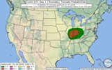
I'd go for it; worst that happens is having to pay for a little extra gas to see some non-tornadic storms. Although that's probably a massive oversimplification.
 
I might just head to northern Illinois (somewhere between the I-88/I-80 corridors, northwest tip of the dark green shading) tomorrow afternoon and hope something overachieves up there. There might well be something good further south, but as so often happens there's just a *bit* too much uncertainty for me to feel like driving that far.
The gamble could very well be worth it. But imo, it is pretty conditional. If storms fire, and sustain, and go surface based, then your gamble is good. But there's a lot of roadblocks for tmrw despite the ceiling down south. I'm not optimistic on much happening rn due to those factors
 
Oh we’re finally back online , so..
SPC day 1:

LOW PRESSURE WILL DEEPEN INTO MO DURING THE DAY AND MOVE INTO LOWER MI BY 12Z FRIDAY. A 40 KT LOW-LEVEL JET BENEATH STRONG MIDLEVEL WINDS WILL RESULT IN LONG HODOGRAPHS, AND, 200-300 M2/S2 SRH OVER MUCH OF THE WARM SECTOR INCLUDING EASTERN MO, IL, IN, KY, AND OH. STRONG HEATING OVER MO WILL RESULT IN STEEP LAPSE RATES AND STORMS ARE LIKELY TO FORM THERE NEAR 12-15Z. THIS ACTIVITY SHOULD GENERALLY
SPREAD NORTHEASTWARD DURING THE DAY ACROSS IL AND IN, PERHAPS
EXTENDING INTO WESTERN KY. A COUPLE SUPERCELLS APPEAR LIKELY, WITH TORNADO/HAIL/WIND POTENTIAL.
 

Attachments

  • IMG_4763.jpeg
    IMG_4763.jpeg
    107.3 KB · Views: 0
HRRR still seems pretty bullish on this event with its past couple runs. Some semi discrete cells popping up along and just north of the Ohio river with a pretty impressive environment, especially by February standards. Many of the other CAMs aren’t impressed though. I think keeping a slight risk is the play here unless it becomes very apparent that we’re going to trend in the direction of the HRRR. At that point, though, using any model may be nowcasting.
 
HRRR still seems pretty bullish on this event with its past couple runs. Some semi discrete cells popping up along and just north of the Ohio river with a pretty impressive environment, especially by February standards. Many of the other CAMs aren’t impressed though. I think keeping a slight risk is the play here unless it becomes very apparent that we’re going to trend in the direction of the HRRR. At that point, though, using any model may be nowcasting.
The environment is decent, it's just warming aloft/warm nose. Sigtor threat is there, it's just conditional.

Moisture issues also evident now. Getting harder to believe sustained supercell development may do much but it's time for nowcasting pretty much
 
HRRR still seems pretty bullish on this event with its past couple runs. Some semi discrete cells popping up along and just north of the Ohio river with a pretty impressive environment, especially by February standards. Many of the other CAMs aren’t impressed though. I think keeping a slight risk is the play here unless it becomes very apparent that we’re going to trend in the direction of the HRRR. At that point, though, using any model may be nowcasting.
1771508027237.png
ig spc agees as we now have a 10sig so they must see something we don't
 
Well. 10# issued. I am not in agreement with this due to several conditional factors but I agree on the chances of potential sigtors. It is the confidence in this threat I'm uncertain on. Regardless, SPC knows best. Trust them!
 

Attachments

  • Screenshot_2026-02-19-13-33-41-494.jpeg
    Screenshot_2026-02-19-13-33-41-494.jpeg
    51.7 KB · Views: 0
View attachment 50665
ig spc agees as we now have a 10sig so they must see something we don't
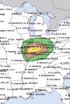
Damn it, my first instance of being beaten to it on this forum LOL

I think there's issues with this setup tbh. I might just be conservative but I mean, the warming aloft, the warm nose, the potential moisture/boundary layer issues. Could any of our mets fill in on today?
 
Back
Top