2/15/25 SE Severe Threat

Jason Mills

Member
Messages
109
Reaction score
433
Location
Troy, AL
Special Affiliations
  1. SKYWARN® Volunteer
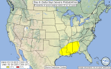
Global models are in good agreement concerning a severe risk over a large portion of the SE on Saturday.
SPC has highlighted a 15% risk for D6.

THERE HAS BEEN A CONSISTENT SIGNAL FOR A POTENT UPPER-LEVEL TROUGH
TO MOVE INTO THE WEST COAST ON FRIDAY. IN RESPONSE TO THIS TROUGH, A
DEEP SURFACE LOW IS EXPECTED TO DEVELOP IN EASTERN COLORADO AND MOVE
INTO OKLAHOMA. THESE FEATURES WILL PROMOTE STRONG MOISTURE RETURN
INTO PARTS OF THE CENTRAL GULF COAST STATES LATE FRIDAY INTO
SATURDAY. APPRECIABLE MOISTURE RETURN MAY REACH INTO THE MID-SOUTH.
THIS SETUP WOULD FAVOR SCATTERED TO NUMEROUS SEVERE STORMS FROM THE
SABINE VALLEY VICINITY INTO MUCH OF MISSISSIPPI/ALABAMA. BOTH
LOW-LEVEL AND DEEP-LAYER SHEAR WOULD BE STRONG IN THIS REGIME. THE
SURGING COLD FRONT WILL LIKELY BE THE PRIMARY FOCUS FOR STORMS, BUT
THE STRONG SYNOPTIC FORCING WITHIN A POTENTIALLY WEAKLY CAPPED
BOUNDARY-LAYER COULD ALSO BRING ABOUT MORE DISCRETE STORMS AHEAD OF
THE LINE AS WELL. THE PRIMARY UNCERTAINTIES WILL BE THE
TIMING/AMPLITUDE OF THE TROUGH AS WELL NORTHWARD/EASTWARD EXTENT OF
SUFFICIENT BUOYANCY. WITH THE CONSISTENT SIGNAL IN DETERMINISTIC AND
ML GUIDANCE, 15% SEVERE PROBABILITIES APPEAR WARRANTED FOR SATURDAY.
REFINEMENT OF THE HIGHLIGHTED AREA IS PROBABLE AS ADDITIONAL DATA
BECOMES AVAILABLE.
 

Attachments

  • spccoday6.severe.latest.png
    spccoday6.severe.latest.png
    206.9 KB · Views: 0
Yup, signal appears to be quite strong, will get a much better idea once the closer range, higher res models drop. But I feel we def may have a decent lil event on our hands.
 
All the broad-level details are there, seems like smaller-scale things are the big uncertainties. Exact timing of trough ejection will be a big one.

Also, might be good to move some of the posts from the annual thread over to here and pin this to the top.
 
All the broad-level details are there, seems like smaller-scale things are the big uncertainties. Exact timing of trough ejection will be a big one.

Also, might be good to move some of the posts from the annual thread over to here and pin this to the top.
A rather favorable low position and strength for a robust event in central and southern parts of central Alabama. It Seems we like to get a robust February event once in a while here lol
 
Last edited:
I expect those Instability values to rise drastically once we are in mesoscale range. Mid upper 60s dewpoints is not going to be sub 1000j of instability LUL

Even if CAPE is sub 1,000 j/kg, you can still get significant severe weather. The median MLCAPE in MS/AL for significant tornadoes is only 755 j/kg

envbws.gif
 
Even if CAPE is sub 1,000 j/kg, you can still get significant severe weather. The median MLCAPE in MS/AL for significant tornadoes is only 755 j/kg

View attachment 33514
Yeah especially in the winter season, I actually didn't realize the GFS has cape values around 1500j in Mississippi for the event. Its around sub 1000 in Alabama though lol. I expect those to rise a good bit still.
 
I remember this outbreak well.
Animated GIF


I remember it as well.
 
Especially with an uptick in instability, I could see this event having a relatively high ceiling.

2025021018_GFS_129_32.50,-88.11_severe_mu.png

I'm very curious to see what happens in the warm sector ahead of the cold front, and how it evolves over the next few days. H5 height falls across the region and 0-6km shear vectors having a component across the boundary lead me to suspect the possibility of discreet convection before the forcing becomes more linear overnight into Sunday.
 
Especially with an uptick in instability, I could see this event having a relatively high ceiling.

View attachment 33517

I'm very curious to see what happens in the warm sector ahead of the cold front, and how it evolves over the next few days. H5 height falls across the region and 0-6km shear vectors having a component across the boundary lead me to suspect the possibility of discreet convection before the forcing becomes more linear overnight into Sunday.
lapse rates are money maker in the sfc to 3km, if those improve then issues exist, but we have had many events in recent with very high ceilings that just didn't do much cuz d alapse rates was at a 5.8 or what not
 
Seen some talk online (not here) at about how this event seems lacklustre or unimpressive… but I would definitely disagree.

Latest GFS run brings nearly 2000j/kg of SBCAPE into parts of MS,LA, AR on Saturday. Yes it’s just one run, but this is the GFS… at 4/5 days range… in winter. Kinematic seem unlikely to be a major issue. Meanwhile the trough ejection and geometry seems to be trending more favourable.

A lot can and often does change in 110-120 hours of weather forecasting, but this one certainly seems worth watching closely regardless.
100% agreed. Again, it normally isn’t a good sign that the SPC has issued a warning so early in advance. That definitely means something has caught their attention.
 
Back
Top