TornadoFan
Member
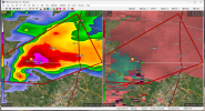
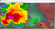
Cooley has a tornado. Multi-vortex
Follow along with the video below to see how to install our site as a web app on your home screen.
Note: This feature may not be available in some browsers.
this thing is a slow mover
New warning polygon dips further south… meaning this thing could go right through Waco
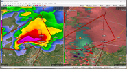
 Hope the cow is ok...
Update on the bull: owner says he's ok, per this TweetGoodness!
.THERE IS A SLIGHT RISK OF SEVERE THUNDERSTORMS ACROSS PORTIONS OF
THE GULF STATES AND EASTERN FLORIDA PENINSULA...
...SUMMARY...
Scattered severe storms are expected along much of the Gulf Coast
Thursday, from portions of southern Texas and southern Louisiana
into the Florida Panhandle. Damaging gusts, large hail, and a few
tornadoes will all be possible. Isolated severe thunderstorms are
also expected across the eastern Florida Peninsula. Hail/wind are
the primary concerns with this activity.
...Gulf States...
Upper low over the southern Plains is forecast to progress to near
the OK/AR border by 18z, then weaken as it ejects northeast into the
lower OH Valley late in the period. Substantial mid-level flow has
translated through the base of the trough and will spread across the
lower MS Valley early, then into the southeastern States where
speeds should lessen by 28/12z. At the surface, substantial
instability is currently suppressed to coastal regions and latest
model guidance suggests the primary synoptic boundary will struggle
to move appreciably north until late in the period over the
Carolinas.
Early this morning, an expansive MCS has evolved over east TX into
northern LA. This complex of storms will propagate east-southeast
along the Gulf Coast during the day, ultimately propagating toward
the FL Panhandle by early afternoon. While deep-layer flow/shear
will support supercells, the primary storm mode should be an MCS.
Some tornado threat does exist with embedded supercells though.
Otherwise, damaging winds are the primary threat.
Significant buoyancy currently resides across deep south TX. This
air mass is expected to support isolated strong/severe thunderstorms
as the front surges into this region. Given the steep lapse rates,
very large hail may accompany any supercells before they propagate
south of the international border.
Another region where a few strong/severe thunderstorms may develop
is across the Mid-South. Cold mid-level temperatures will spread
across AR into western TN and convection is expected to develop
during the afternoon north of the mid-level jet. Forecast soundings
suggest very steep lapse rates may be adequate for robust updrafts
given the 50s surface dew points. At this time will maintain MRGL
Risk for hail/wind, however probabilities may need to be adjusted
for this region in later outlooks.
...FL Peninsula...
Strong boundary-layer heating is once again expected across the FL
Peninsula today. Diabatic heating proved instrumental in scattered
severe convection Wednesday and this type of coverage may once again
develop by afternoon. Mid-level temperatures remain seasonally cool
and strong buoyancy is expected. Forecast soundings favor
southeastward-moving supercells and hail/wind are the primary
threats.
...Central High Plains Region...
Strong 500mb speed max will dig south across MT/eastern
ID/southwestern WY by late afternoon. Cold mid-level temperatures
and steep lapse rates will result in thermodynamic environment
favorable for surface-based convection. Forecast soundings suggest
convective temperatures will be breached by 20-21z. Gusty winds will
likely accompany this activity as it spreads southeast in
association with a surging frontal zone.