
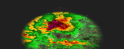
Same massive supercell from earlier that got warned I guess it finally dropped.Spotter confirmed tor in Louisiana, going through Elizabeth, LA
Sent from my iPhone using Tapatalk
Navigation
Install the app
How to install the app on iOS
Follow along with the video below to see how to install our site as a web app on your home screen.
Note: This feature may not be available in some browsers.
More options
-
Welcome to TalkWeather! We see you lurking around TalkWeather! Take the extra step and join us today to view attachments, see less ads and maybe even join the discussion. CLICK TO JOIN TALKWEATHER
You are using an out of date browser. It may not display this or other websites correctly.
You should upgrade or use an alternative browser.
You should upgrade or use an alternative browser.
Severe WX March 26th-27th, 2023
- Thread starter JBishopwx
- Start date
Gawxnative
Member
Noticing the movement of the two "groups" of cells near Columbus GA and the degree thay are diverging from each other.. If that is a sign of that divergence could spell issues later maybe??
warneagle
Member
Yeah I mean take the simulated reflectivity seriously not literally, but it's kind of riding along the boundary right along I-20 so it's not completely out of left field.Oh mercy! That’s almost always a hot spot…and I sit directly between the two cities on I20/59/459…so tired of that! Guess it’s not wise to live near a store called “Target”.

That Oakdale tornado warning is going to be a major issue if it keeps it's structure for a while. I think it's riding the boundary.
There are around 4-5 discrete/semi-discrete cells in South LA trying their best to form hooks (I think the oak dale cell has one on the ground).
Just crazy, it’s a good thing the low level shear isn’t great over the areas they are in (right now).
Just crazy, it’s a good thing the low level shear isn’t great over the areas they are in (right now).
Tornado warning allowed to expire on it. Just Severe T warned for nowThat Oakdale tornado warning is going to be a major issue if it keeps it's structure for a while. I think it's riding the boundary.
It'll be back , it's growing a more healthy mesocyclone now actually.Tornado warning allowed to expire on it. Just Severe T warned for now
warneagle
Member
Yeah the shear should increase with time as the LLJ ramps up, but for now the only area where there's enough low-level shear to support any kind of sustained rotation is right along the boundary (and even there it's not overly impressive yet). The sigtor threat in the immediate area around the boundary over the next few hours is obvious; the real question is whether there's enough shear available for any cells that pop in the OWS to sustain themselves. The HRRR and the RAP both want to pop one or two in central Alabama in a few hours.There are around 4-5 discrete/semi-discrete cells in South LA trying their best to form hooks (I think the oak dale cell has one on the ground).
Just crazy, it’s a good thing the low level shear isn’t great over the areas they are in (right now).
warneagle
Member
Might want to go move those cars out of the driveway and into the garage...There's a nasty-looking cell that will be hitting Jackson, MS, within the next half-hour or so!
Starting to broadly wrap up as well it looks likeThere's a nasty-looking cell that will be hitting Jackson, MS, within the next half-hour or so!
Jetstream
Member
Big hail on the storm along I 20 west of Jackson Miss
Chris3024
Member
GRA printing 3in hail with the storm west of Jackson
.making sure I'm not the only one noticing this but does it not seem like it's creating a huge mesocyclone? Seems to be getting a decent inflow on it.
It's about to do a merger as well. Those can initiate rapid meso strnegthening
It's about to do a merger as well. Those can initiate rapid meso strnegthening
Brice
Member
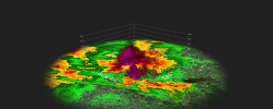
that Louisiana storm down in Bunkie, what a crazy structure on it
TH2002
Member
- Messages
- 4,974
- Reaction score
- 11,116
- Location
- California, United States
- Special Affiliations
- SKYWARN® Volunteer
The main supercell in LA has a nasty hook again

Gawxnative
Member
Plus couple that size hail with 70 MPH winds pushing it..Hail core Brandon, MS