
I will put this pretty bluntly Arkansas is in some danger one HECK of a environment. @WesL I think this is your area not sure if they'res many Arkansas board members other than you
Navigation
Install the app
How to install the app on iOS
Follow along with the video below to see how to install our site as a web app on your home screen.
Note: This feature may not be available in some browsers.
More options
-
Welcome to TalkWeather! We see you lurking around TalkWeather! Take the extra step and join us today to view attachments, see less ads and maybe even join the discussion. CLICK TO JOIN TALKWEATHER
You are using an out of date browser. It may not display this or other websites correctly.
You should upgrade or use an alternative browser.
You should upgrade or use an alternative browser.
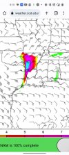
Severe WX Severe Wx Outbreak March 1st- 3rd, 2023 - Southern States, MS/OH/TN Valley
- Thread starter KevinH
- Start date
cincywx
Member
Area Forecast Discussion
National Weather Service Little Rock AR
520 AM CST Tue Feb 28 2023
.DISCUSSION...
Issued at 447 AM CST Tue Feb 28 2023
...Regional severe weather outbreak and flooding expected Thursday
and Thursday night...
No mincing words with this discussion as concern in seeing some
severe potential on Wed, followed by a potentially significant
severe weather outbreak on Thurs into Thurs night, has further
increased this morning. While some details remain unclear between
these two episodes, the overall setup appears to be more than
conducive for significant severe weather on Thurs, including several
tornadoes (some strong/violent), widespread damaging winds, and
large hail. The flood threat has also increased significantly from
previous cycles with an area of enhanced flood potential over much
of central into NErn AR. River flooding is also expected with
potentially worsening conditions within an already flooded White
River Basin. Details below...
[...]
Thursday severe threat...
Guidance remains in very good agreement with the overall synoptic
evolution thru Thurs while mesoscale details remain less clear. The
primary culprit for this uncertainty is the positioning of the
aforementioned warm front, which may evolve into a composite frontal
configuration with the primary front draped over Srn MO and a
secondary boundary across central AR as depicted in sfc theta-e
fields. This positioning will be critical as the most volatile
overlap of thermodynamic/kinematic parameters will exist along/S of
the secondary boundary. Further complicating this is the potential
for early day precip and terrain to alter the northward extent of
the richest BL air and this bears out in lingering model variability
regarding sfc fields.
Regardless of where the boundary stalls, the warm sector to its S
will be thermodynamically primed with SBCAPE values in excess of
2000 J/kg. Flow aloft will intensify as the upper cyclone nears and
the deepening sfc cyclone moves NEwrd across Ern OK into Wrn/NWrn
AR. Resultant sfc wind fields will exhibit a high degree of backing
with speeds increasing to over 15 kts by evening. While this occurs,
a remarkable LLJ is forecast to develop into the overnight hours
across much of Ern AR with flow in excess of 60 to 70 kts near the
H850 layer. This will readily enlarge already looping hodographs and
greatly increase the tornado threat assuming favorable convective
development and storm morphology.
Deep-layer bulk shear in the 60 to 80 kt range will undoubtedly
support storm organization, and the progged instability values
suggest enough shear/instability balance for multiple convective
modes, including supercells capable of large hail and damaging winds
in addition to tornadoes. The main point of uncertainty here will be
storm initiation and the evolution of convective modes given some
phasing differences between the warm sector and brunt of synoptic
ascent, which may lag to the W some thru much of the day Thurs. Will
also have to refine storm timing as finer-scale details become more
clear, but severe will be possible thru the day on Thurs with the
highest concern late afternoon into the early overnight based on
current data.
Best case scenario for AR will be enough shower activity earlier in
the day such that the effective warm front gets shunted farther S
than current progs indicate. While this scenario would lessen the
higher-end severe risk for AR, at least iso/sctd severe storms would
remain possible over the Srn half of the state.
Worst case scenario for AR generally isn`t too far above the going
fcst, unfortunately. Should the effective warm front lift more Nwrd -
- which may be hard to achieve based on the likelihood of at least
some more persistent WAA-generated precip during the day -- more of
the state will reside within the volatile warm sector and a more
widespread severe outbreak could materialize.
Invariably, there will be potential for other meso-or finer-scale
failure points that cannot be resolved attm, but we hope to iron
those details out in the next few fcst cycles. Bottom line: this is
shaping up to be one of the more significant severe threats we`ve
seen in a while. All interests should monitor future fcsts closely
as changes are a given, and we would be quite lucky to see this
event bust or trend back towards a best case scenario. That does not
appear to be likely, however.
fascinating AFD from LZK that i have condensed into just the relevant section.


GTWXAlum
Member
NWS Nashville highlighted 3 potential periods of severe weather for middle Tennessee (Wednesday afternoon/evening, Thursday, Thursday night/Friday)..I'll be watching all of these closely


Gunna add to your post from a minute ago @WxMan42711
Gail
Member
As it stand now, it’ll come through here early pre-Dawn morning hours. I hate overnight systems. 
- Thread starter
- #491
KevinH
Member
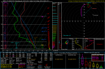
West GA STP and sounding.

Also it may be a bit before we get updates from trey at convective chronicles, supposedly he was affected by the Oklahoma tornado a couple days ago and it really shook him up.
*Updated * Of course as I post that he uploads within 15 minutes hahaha
*Updated * Of course as I post that he uploads within 15 minutes hahaha
Last edited:
Stupid question but is this the most volatile environment in Arkansas since vilonia Arkansas tornado?
tornado examiner
Member
Doesn’t that go too December 10th though? I mean surely the environment responsible for the tristate ef4 has too count for something…Stupid question but is this the most volatile environment in Arkansas since vilonia Arkansas tornado?
I keep forgetting about that event, I did it earlier lol good grief. I feel like I have a void they're hahaDoesn’t that go too December 10th though? I mean surely the environment responsible for the tristate ef4 has too count for something…
tornado examiner
Member
OofI keep forgetting about that event, I did it earlier lol good grief. I feel like I have a void they're haha
- Moderator
- #497
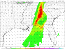
Models show an enhanced risk with tomorrow’s threat.
NorthGaWeather
Member
Here is a good paper on veer back.Looks like some veer back in Arkansas, I'm not a expert on it but, that may be a issue for an upper echelon environment for tornadoes

How Much Does “Backing Aloft” Actually Impact a Supercell?
Abstract Among forecasters and storm chasers, there is a common perception that hodographs with counterclockwise curvature or kinking in the midlevels (sometimes called backing aloft or veer–back–veer profiles) are unfavorable for long-lived supercells and tornadoes. This study reviews and then...
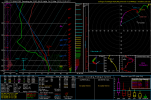
Yikes.West GA STP and sounding.
According to the article the effects are little if there is high SRH Helicity. Well they'res your answer incredible shear with this event lolHere is a good paper on veer back.
How Much Does “Backing Aloft” Actually Impact a Supercell?
Abstract Among forecasters and storm chasers, there is a common perception that hodographs with counterclockwise curvature or kinking in the midlevels (sometimes called backing aloft or veer–back–veer profiles) are unfavorable for long-lived supercells and tornadoes. This study reviews and then...journals.ametsoc.org