
Navigation
Install the app
How to install the app on iOS
Follow along with the video below to see how to install our site as a web app on your home screen.
Note: This feature may not be available in some browsers.
More options
-
Welcome to TalkWeather! We see you lurking around TalkWeather! Take the extra step and join us today to view attachments, see less ads and maybe even join the discussion. CLICK TO JOIN TALKWEATHER
You are using an out of date browser. It may not display this or other websites correctly.
You should upgrade or use an alternative browser.
You should upgrade or use an alternative browser.
Severe WX December 10 & 11, 2021 Severe Threat
- Thread starter Richardjacks
- Start date
warneagle
Member
Worth noting that Joplin was rated EF5 based on things like those parking stops, since most of the houses weren't of "superior" construction.
MNTornadoGuy
Member
it was also seen in El Reno 2013 and Vilonia 2014. Joplin had the most extreme case though as they were thrown hundreds of yards I believe.Yup that was one of the things that lead to an EF5 rating in Joplin. Worth noting that it’s been seen in other less violent tornadoes, most notably an EF2 that went through a prison parking lot near Blountstown, FL in 2014.
The one on El Reno and Mayflower was unreinforced which can be moved by winds relatively easy. I'm not entirely sure the one on Dawson Springs was reinforced but I found rebar on the other side of the moved lot. The one in Joplin was really nuts since these rebars very easily can be seen.it was also seen in El Reno 2013 and Vilonia 2014. Joplin had the most extreme case though as they were thrown hundreds of yards I believe.

Last edited:
One thing about this picture that always confused me is how each piece of rebar on each end of the concrete parking stops is bent in an opposite direction. Clearly some really complex small-scale stuff going on here within all the destruction. Super weird.The one on El Reno and Mayflower was unreinforced which can be moved by winds relatively easy. I'm not entirely sure the one on Dawson Springs was reinforceD but I found rebar on the other side of the moved lot. The one in Joplin was really nuts since these rebars very easily can be seen.
View attachment 11214
Also, why in the world are there no damage points higher than EF3 in Princeton? If they want to be extremely pedantic about all the CMU foundation homes in town, then fine, but the damage at and around the UK Research facility was clearly violent, yet the damage point for it has not come back since it disappeared. Only thing I can hope for is that they are considering a higher windspeed estimate for that structure (which it clearly does deserve given the blueprints).
MNTornadoGuy
Member
They are probably going to be added last.Also, why in the world are there no damage points higher than EF3 in Princeton? If they want to be extremely pedantic about all the CMU foundation homes in town, then fine, but the damage at and around the UK Research facility was clearly violent, yet the damage point for it has not come back since it disappeared. Only thing I can hope for is that they are considering a higher windspeed estimate for that structure (which it clearly does deserve given the blueprints).
thundersnow
Member
It appears the concrete stops were “twisted” right out of the pavement… picturing them being spun out counterclockwise, which would explain the rebar bent in opposite directions on each end.One thing about this picture that always confused me is how each piece of rebar on each end of the concrete parking stops is bent in an opposite direction. Clearly some really complex small-scale stuff going on here within all the destruction. Super weird.
That actually makes complete sense. Thanks for the explanation!It appears the concrete stops were “twisted” right out of the pavement… picturing them being spun out counterclockwise, which would explain the rebar bent in opposite directions on each end.
MNTornadoGuy
Member
Aerial footage of scouring near Cayce
Welp there is some footage of the third trench.
Drone video of the damage in the general vicinity of Princeton including the UK research facility. The end of the video shows multiple slabbed homes east of LBTL and I-24. For some reason, they were given a blanket rating of EF3, 150 mph despite containing the following description.
Like what? Satellite images suggest that minimal cleanup took place with the drone footage at 12:30-12:40 in. A reminder that the lower bound for DOD 10 to 1-2 FR as suggested by the damage description is 165 mph.

Around a dozen homes received considerable damage. Some wiped clean to foundation.
Like what? Satellite images suggest that minimal cleanup took place with the drone footage at 12:30-12:40 in. A reminder that the lower bound for DOD 10 to 1-2 FR as suggested by the damage description is 165 mph.
MNTornadoGuy
Member
Drone video of the damage in the general vicinity of Princeton including the UK research facility. The end of the video shows multiple slabbed homes east of LBTL and I-24. For some reason, they were given a blanket rating of EF3, 150 mph despite containing the following description.
Like what? Satellite images suggest that minimal cleanup took place with the drone footage at 12:30-12:40 in. A reminder that the lower bound for DOD 10 to 1-2 FR as suggested by the damage description is 165 mph.
View attachment 11215
Looks like most of those homes were very poorly-anchored.
locomusic01
Member
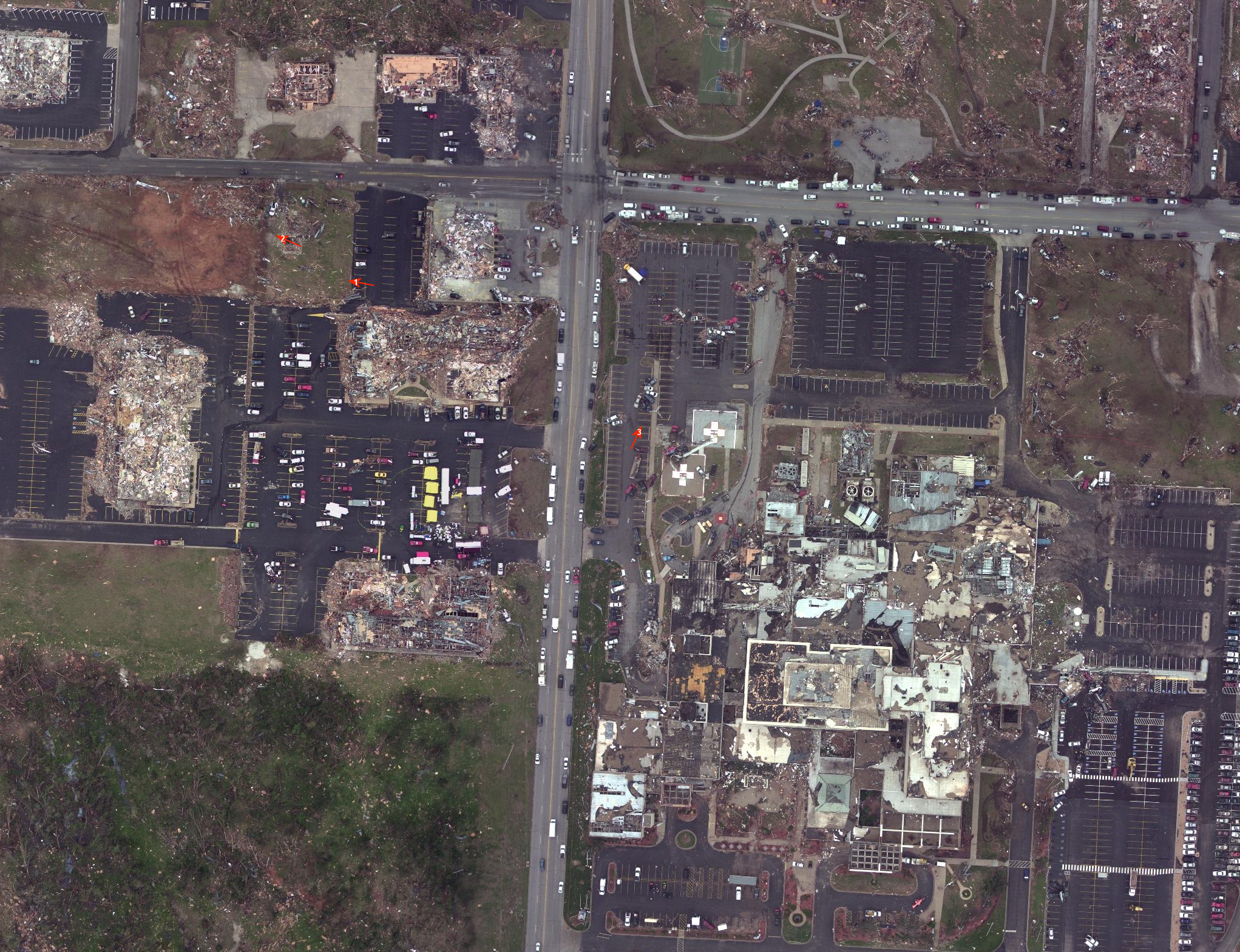
Not to get too far off-topic here, but this was one of the things I found fascinating back when I was researching my article. Not only were most of the parking stops seemingly twisted as they were lifted, they were thrown all over the place in a random pattern. The arrows here just mark where some of the ground-level photos were taken, but if you look closely (probably need to go full-size) you can see parking stops scattered all over. Definitely suggests some chaotic wind flow patterns.One thing about this picture that always confused me is how each piece of rebar on each end of the concrete parking stops is bent in an opposite direction. Clearly some really complex small-scale stuff going on here within all the destruction. Super weird.
I don't see how it's possible to determine that from drone footage, but at the very minimum the damage there should be 165 mph, that is what the EF-scale dictates.Looks like most of those homes were very poorly-anchored.
MNTornadoGuy
Member
It appears that the CMU at the UK research center was reinforced.


Footage from the Cambridge Shores video showing intense tree damage.

Footage from the Cambridge Shores video showing intense tree damage.
ARCC
Member
Aerial footage of scouring near Cayce
Honestly, while interesting, less impressive than many of the other damage pictures posted.
Austin Dawg
Member
I noticed that storm chasers are putting up their experiences from that night or at least they are showing up in my feed. This video from Max Olson Chasing is amazing and frightening at the same time. He intercepts this monster as it crosses I-55 in Arkansas. The footage is indescribable especially as he watches it enter and demolish a town nearby. Make sure you watch the footage after it passes his location. This is very dramatic at least to me. I'll share more as I get them.