• Welcome to TalkWeather!
    We see you lurking around TalkWeather! Take the extra step and join us today to view attachments, see less ads and maybe even join the discussion.
    CLICK TO JOIN TALKWEATHER

Severe WX Severe Weather Threat 3/26-3/29, 2020

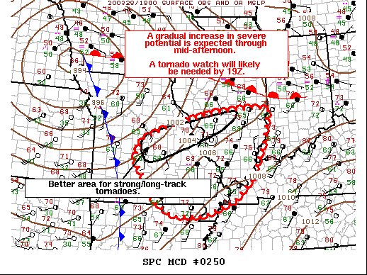
MD is up for the area south of the main threat

EUN0KYQUwAAmAV-
 
90/80. SPC really not backing down
They must be seeing signs that many of us aren't, or are otherwise confident that ingredients are either in place or will still be able to come into place for at least a significant tornado event.

And remember, it doesn't necessarily have to be a big outbreak with multiple dangerous tornadoes. If there's only a single tornado today, but it causes significant damage and casualties, that's all it takes for it to become a significant event. Just look at 3/2-3/3/20 for a recent example of this.
 
Last edited:
This seems more of an "if a cell hits the right area" type of day where we could easily see one supercell drop monsters or just as easily see a puff of smoke. If the right storm gets going though, you've already got mid-upper 60s dews reported throughout central IL and there's every possibility that could continue. I'm thinking they might move things a little bit south, the warm front really hasn't penetrated further north and the rain shield out there earlier doesn't seem to favor serious instability.
 
That storm just to the NW of Indianapolis has an ominous look on radar. Any rotation in that?
 
Moderate stays. Too much uncertainty on cloud cover, moisture extent, and exact location of highest risk corridor. Probably a good call not going high.
 
1585428845466.png


Indiana is more active than Illinois but limited to hail.

Illinois predictions underperforming so far. 14z HRR was showing initiation not happening until 22z. Maybe Illinois goes more severe later.

Or not.
 
Back
Top