• Welcome to TalkWeather!
    We see you lurking around TalkWeather! Take the extra step and join us today to view attachments, see less ads and maybe even join the discussion.
    CLICK TO JOIN TALKWEATHER

Hurricane Nolo (Hawaii threat)

Atlantic

Member
Messages
2,554
Reaction score
4,489
Location
Virigina
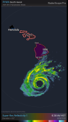
Tropical Depression Fifteen-E formed in the EPAC on September 14th, and degraded to a remnant low among wind shear and dry air on September 16th. However its remnant circulation remained traceable as it moved generally westwards and crossed 140W into the CPAC basin, where on September 22nd it regenerated into a tropical depression and later on September 23rd became Tropical Storm Nolo. Nolo is currently threatening the Hawaiian Islands much like Hurricane Lala, and later Hurricane Lowell did, so I thought a thread would be warranted for the hurricane.
IMG_2643.jpeg
 
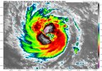
Nolo will be intriguing. It will be in a good environment, to the point I'm thinking major just like the NHC. But I do have questions such as dry air on its southern quadrant and it will consistently interact with shear so its peak may not last too long. I'm not exactly a expert on tropical wx just like I am svr but I know enough, I suppose LOL.
 
Nolo as I said has good potential for major, but between Tuesday and Wednesday, the system should struggle and weaken to a borderline hurricane.

Albeit, the 1st of October is out there still but there is agreement that as Nolo reorganises ahead of dry air/shear, a second bout at significance crossing into the EPAC seems probable. I won't go into exact intensity for obvious reasons as hurricanes are a lot more finicky to forecast but Nolo will not be done in this hyperactive ocean, it'll have a little lull and then it'll be back

On a side note, i expect it to intensify decently over the next 12-24 hours or so.
 
Nolo is explicitly forecast by the NHC to be a C5 hurricane now by 12z tomorrow:

FORECAST POSITIONS AND MAX WINDS

INIT 28/0300Z 16.3N 160.3W 125 KT 145 MPH
12H 28/1200Z 16.9N 161.7W 140 KT 160 MPH
24H 29/0000Z 18.3N 163.1W 130 KT 150 MPH
36H 29/1200Z 20.2N 163.8W 115 KT 130 MPH
48H 30/0000Z 21.9N 163.8W 100 KT 115 MPH
60H 30/1200Z 22.8N 163.7W 80 KT 90 MPH
72H 01/0000Z 23.0N 164.2W 65 KT 75 MPH
96H 02/0000Z 23.7N 166.4W 60 KT 70 MPH
120H 03/0000Z 24.3N 168.3W 65 KT 75 MPH

Forecaster Kelly
 
Nolo is explicitly forecast by the NHC to be a C5 hurricane now by 12z tomorrow:

FORECAST POSITIONS AND MAX WINDS

INIT 28/0300Z 16.3N 160.3W 125 KT 145 MPH
12H 28/1200Z 16.9N 161.7W 140 KT 160 MPH
24H 29/0000Z 18.3N 163.1W 130 KT 150 MPH
36H 29/1200Z 20.2N 163.8W 115 KT 130 MPH
48H 30/0000Z 21.9N 163.8W 100 KT 115 MPH
60H 30/1200Z 22.8N 163.7W 80 KT 90 MPH
72H 01/0000Z 23.0N 164.2W 65 KT 75 MPH
96H 02/0000Z 23.7N 166.4W 60 KT 70 MPH
120H 03/0000Z 24.3N 168.3W 65 KT 75 MPH

Forecaster Kelly
Wild stuff

 
Last edited:
Back
Top