
- Admin
- #1
Navigation
Install the app
How to install the app on iOS
Follow along with the video below to see how to install our site as a web app on your home screen.
Note: This feature may not be available in some browsers.
More options
-
Welcome to TalkWeather! We see you lurking around TalkWeather! Take the extra step and join us today to view attachments, see less ads and maybe even join the discussion. CLICK TO JOIN TALKWEATHER
You are using an out of date browser. It may not display this or other websites correctly.
You should upgrade or use an alternative browser.
You should upgrade or use an alternative browser.
Severe WX Severe Weather Threat July 1st - 5th 2026
- Thread starter JayF
- Start date
WeathermanLeprechaun
Member
Alright, guys, remember to keep civil........LOL
- Thread starter
- Admin
- #3
Don't forget ladies, even though i think the ladies have been pretty patient with us fellas.Alright, guys, remember to keep civil........LOL
WeathermanLeprechaun
Member
Yeah, id say the ladies deserve something for putting up with these threads the last few weeks hahaDon't forget ladies, even though i think the ladies have been pretty patient with us fellas.

- Thread starter
- Admin
- #6
Yeah LOL just reminding everyone that 10 years from now, people are going to read this and decide if 1 wow those people are gripy and weird and what is twitter, or 2, those people really knew what they were talking about. if they only knew then what we knew now.Wait.... aren't all the threads saved for historical purposes @JayF? lol
WeathermanLeprechaun
Member
Some weather archivist will stumble upon one of these threads like the EF debate thread in 20 years, when everything's good with the EF scale, ratings are accurate.... And they're gonna see a bunch of randomers from Ireland, Colorado ans Iowa bickering over a EF4's rating. That's funny to think of. Oh, and also all the arguments on here during a thread too. LOL.Yeah LOL just reminding everyone that 10 years from now, people are going to read this and decide if 1 wow those people are gripy and weird and what is twitter, or 2, those people really knew what they were talking about. if they only knew then what we knew now.
- Thread starter
- Admin
- #8
In 20 years, we will not have the EF scale. Instead we will more than likely have the EFM scale LOL.Some weather archivist will stumble upon one of these threads like the EF debate thread in 20 years, when everything's good with the EF scale, ratings are accurate.... And they're gonna see a bunch of randomers from Ireland, Colorado ans Iowa bickering over a EF4's rating. That's funny to think of. Oh, and also all the arguments on here during a thread too. LOL.
Cyclonic Paracosm
Member
the IFEFTORRO scale iirceIn 20 years, we will not have the EF scale. Instead we will more than likely have the EFM scale LOL.
WeathermanLeprechaun
Member
Sure, let's rate this tornado a IFEFTORRO1the IFEFTORRO scale iirce
- Thread starter
- Admin
- #11
Anyone remember the IT Crowd and they had that new phone number? Yeah that is what IFEFTORRO1 feels like.the IFEFTORRO scale iirce
akt1985
Member
Some of these areas with a severe risk tomorrow are also under Heat Advisories and Excessive Heat Warnings at the same time.
KevinH
Member
Very fair lolYeah LOL just reminding everyone that 10 years from now, people are going to read this and decide if 1 wow those people are gripy and weird and what is twitter, or 2, those people really knew what they were talking about. if they only knew then what we knew now.
Kds86z
Member
WeathermanLeprechaun
Member
The gripe about today is low level shear and cells in a SW-NE orientation. That is a notorious wildcard for undercut supercells or proper propagating stuff. 4/28/25, 5/18/26, 5/6/24 to a extent. Not saying today has a ceiling like that but this orientation rarely ever works out for tornadoes
Must note I mean this in general, close proximity SW-NE orientation doesn't usually work. A orientation like 3/14/25 worked perfectly fine. That wasn't as extreme
Must note I mean this in general, close proximity SW-NE orientation doesn't usually work. A orientation like 3/14/25 worked perfectly fine. That wasn't as extreme
Last edited:
Kds86z
Member
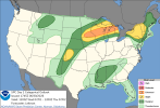
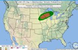
On the latest day 1 it looks like they expanded the 5% hatch for tornadoes and here is discussion.
SEVERE POTENTIAL LATER TODAY WILL FOCUS ON A CONVECTIVELY REINFORCED BOUNDARY, WITH A VERY MOIST AND POTENTIALLY UNSTABLE ENVIRONMENT ALONG AND SOUTH OF IT. RENEWED DEEP CONVECTIVE DEVELOPMENT IS
EXPECTED LATER THIS AFTERNOON INTO TONIGHT ACROSS NORTHERN IOWA AND SOUTHERN MINNESOTA, AND AGAIN INTO WISCONSIN. A RIBBON OF MODERATELY STRONG MID-LEVEL WESTERLIES, SOME OF IT MCV-ENHANCED, WILL SUPPORT ORGANIZED STORM MODES INCLUDING SUPERCELLS AND FAST-MOVING LINE SEGMENTS AND POTENTIAL UPSCALE-MCS DEVELOPMENT. LARGE TO VERY LARGE HAIL WILL BE POSSIBLE WITH THE MORE INTENSE STORMS IN ADDITION TO WIND, WHICH MAY BECOME MORE PREVALENT OF A HAZARD (60-80+ MPH) AS STORM MERGERS LEAD TO A COUPLE OF STRONG TO SEVERE CLUSTERS
DEVELOPING. SOME TORNADO POTENTIAL MAY EXIST AS WELL, PARTICULARLY ALONG THE EFFECTIVE BOUNDARY AND/OR INCREASING THIS EVENING AS A SOUTHWESTERLY LOW-LEVEL REINVIGORATES.
Attachments
Last edited:
Two days of possible severe weather on tap for the Deep South. SPC is monitoring trends for possible SVA issuance later today in the AL/TN/GA region.


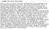
Mesoscale Discussion 1417
NWS Storm Prediction Center Norman OK
1229 PM CDT Wed Jul 01 2026
Areas affected...Northern Georgia into Northern Alabama and southern
Tennessee
Concerning...Severe potential...Watch possible
Valid 011729Z - 011930Z
Probability of Watch Issuance...60 percent
SUMMARY...Thunderstorm development is expected in the coming hours.
Isolated to perhaps scattered strong/severe wind gusts are expected
as thunderstorm coverage increases within a very unstable
environment. Trends are being monitored for watch issuance.
DISCUSSION...Latest GOES imagery and regional web cams show steady
cumulus development and deepening across the southern Appalachians
in northern GA and southern TN with at least a couple of early
attempts at deep convection noted near Birmingham, AL. Any lingering
inhibition is quickly being removed as temperatures continue to warm
into the low to mid 90s, which will support an increasing
probability for sustained convective initiation within the next 1-2
hours as parcels approach their convective temperatures and
localized orographic ascent along terrain features increases.
Initially isolated convection will eventually grow upscale into
multi-cell clusters as development along outflow boundaries
increases given weak low-level flow within a very buoyant ambient
environment. With time, one or more loosely organized clusters
should emerge and propagate westward given the 25-30 knot 4-5 km
flow aloft sampled by regional VWPs.
The combination of seasonally rich low-level moisture (dewpoints in
the mid 70s and PWATs between 1.75 to 2 inches), steepening
low-level lapse rates, and very high buoyancy (MLCAPE upwards of
3500 J/kg) will promote the development of intense, but localized,
wet downbursts capable of producing strong/severe winds (most likely
45-60 mph). Downburst potential will gradually increase in tandem
with thunderstorm coverage and daytime heating through late
afternoon. Convective trends will be monitored, and watch issuance
may be needed for portions of the region if thunderstorm coverage
becomes sufficiently widespread and/or one or more propagating
clusters emerges.
..Moore/Guyer.. 07/01/2026
Storm Prediction Center Mesoscale Discussion 1417
Severe weather, tornado, thunderstorm, fire weather, storm report, tornado watch, severe thunderstorm watch, mesoscale discussion, convective outlook products from the Storm Prediction Center.
www.spc.noaa.gov
- Moderator
- #18
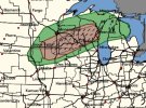
Cullman County gets the first severe t'storm warning of Alabama today until 1:45 pm. I REALLY hope we don't lose power today.
SVA #430 now in effect until 9 PM EDT.Two days of possible severe weather on tap for the Deep South. SPC is monitoring trends for possible SVA issuance later today in the AL/TN/GA region.
View attachment 54012View attachment 54013
Storm Prediction Center Mesoscale Discussion 1417
Severe weather, tornado, thunderstorm, fire weather, storm report, tornado watch, severe thunderstorm watch, mesoscale discussion, convective outlook products from the Storm Prediction Center.www.spc.noaa.gov

akt1985
Member
The severe storms over Georgia and Alabama today are moving the wrong direction.