
- Thread starter
- #501
Navigation
Install the app
How to install the app on iOS
Follow along with the video below to see how to install our site as a web app on your home screen.
Note: This feature may not be available in some browsers.
More options
-
Welcome to TalkWeather! We see you lurking around TalkWeather! Take the extra step and join us today to view attachments, see less ads and maybe even join the discussion. CLICK TO JOIN TALKWEATHER
You are using an out of date browser. It may not display this or other websites correctly.
You should upgrade or use an alternative browser.
You should upgrade or use an alternative browser.
Severe WX Severe Weather Threat June 19-29
- Thread starter Kds86z
- Start date
CheeselandSkies
Member
Monday could be a very volatile day near the warm front/triple point in ND/MN, especially if the moisture/LLJ hangs back west underneath the stronger flow aloft. One of those crazy parameter space days that actually may have a chance to initiate given the amplitude of the trough.
StormNet notably uptrended in its most recent run.
I took Monday off initially when it looked like that set up would happen on Sunday. I have to be back at work 4AM Tuesday so hoping I can target not much further west/north than Albert Lea.
Edit: Unfortunately soundings looked capped to hell around there. Verbatim only viable target is near the Canadian border where some NAM soundings pop the "PDS TOR." GFS gives some hope with a little extra 500mb wave coming through s-central MN around 0Z Tuesday. At least by then 12-hour heights are neutral rather than rising across the target area as they are at 0Z Monday (7 PM CDT Sunday).
Last edited:
- Thread starter
- #503
Kds86z
Member
* TORNADO WATCH FOR PORTIONS OF
WESTERN NORTH DAKOTA
NORTHERN NEBRASKA
WESTERN SOUTH DAKOTA
* EFFECTIVE THIS SATURDAY AFTERNOON AND EVENING FROM 305 PM UNTIL
1100 PM MDT.
* PRIMARY THREATS INCLUDE...
A FEW TORNADOES AND A COUPLE INTENSE TORNADOES POSSIBLE
SCATTERED DAMAGING WINDS LIKELY WITH ISOLATED SIGNIFICANT GUSTS
TO 90 MPH POSSIBLE
SCATTERED LARGE HAIL LIKELY WITH ISOLATED VERY LARGE HAIL EVENTS
TO 3.5 INCHES IN DIAMETER POSSIBLE
SUMMARY...SIGNIFICANT SEVERE STORMS INCLUDING SUPERCELLS ARE
EXPECTED TO DEVELOP REGIONALLY, WITH LARGE HAIL AND SOME TORNADOES
POSSIBLE. A PROMINENT DAMAGING WIND THREAT MAY ALSO UNFOLD INTO THIS
EVENING ACROSS THE WESTERN DAKOTAS.
WeathermanLeprechaun
Member
Not to promote or anything but I found this guy on YouTube and I genuinely think he deserves all the support he can get. He doesn't fearmonger and he keeps it real. Somehow only 600 subs, yet I'd say he's better than Ryan and Max. Currently doing coverage right now of our increasing severe threat.
Not to promote or anything but I found this guy on YouTube and I genuinely think he deserves all the support he can get. He doesn't fearmonger and he keeps it real. Somehow only 600 subs, yet I'd say he's better than Ryan and Max. Currently doing coverage right now of our increasing severe threat.
I don't believe most of the "fearmonger" groups starts off that way. I think it's something more of going from a small you-tuber to a larger you-tuber over a period of time.
Unfortunately, the fearmongering is sometimes the only way for them to grow their channel after it hit its non-fearmongering plateau. I don't think all them do that it with intent to fearmonger, but more so to sustain their business.
- Thread starter
- #506
Kds86z
Member
SUMMARY...THE RISK FOR SUPERCELLS CAPABLE OF PRODUCING SIZABLE HAIL
AND INCREASING POTENTIAL FOR A COUPLE STRONG TORNADOES IS PROBABLY
HIGHEST BETWEEN NOW AND 6-7 PM MDT.
AND INCREASING POTENTIAL FOR A COUPLE STRONG TORNADOES IS PROBABLY
HIGHEST BETWEEN NOW AND 6-7 PM MDT.
joshoctober16
Member
radar is down exactly where the risk is.
joshoctober16
Member
beautiful base

joshoctober16
Member
storm is high base but spinning a lot 

- Thread starter
- #510
Kds86z
Member
- Thread starter
- #511
Kds86z
Member
- Thread starter
- #512
Kds86z
Member
- Thread starter
- #513
Kds86z
Member
Last edited:
- Thread starter
- #514
Kds86z
Member
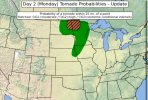
Now Hatched on new day 2.Monday could be a very volatile day near the warm front/triple point in ND/MN, especially if the moisture/LLJ hangs back west underneath the stronger flow aloft. One of those crazy parameter space days that actually may have a chance to initiate given the amplitude of the trough.
StormNet notably uptrended in its most recent run.
IF SUPERCELLS CAN DEVELOP AND BE SURFACE-BASED NEAR THE
WARM FRONT, AN ALL-HAZARDS SEVERE RISK IS EVIDENT GIVEN THE VERY
FAVORABLE THERMODYNAMIC AND KINEMATIC PARAMETER SPACE. WHILE INITIAL
SUPERCELLS ARE POSSIBLE DURING THE EVENING ALONG THE CO
Attachments
joshoctober16
Member
supercell forming again near where a tornado happend a few days ago in eastern canada

WeathermanLeprechaun
Member
Environment tmrw supports intense tornadoes, question is strong and warm mid levels and impact of morning supercells. Highly conditional high ceiling setup and if something does go, it could be a boom
- Thread starter
- #517
Kds86z
Member
Like Enderlin setup ayeEnvironment tmrw supports intense tornadoes, question is strong and warm mid levels and impact of morning supercells. Highly conditional high ceiling setup and if something does go, it could be a boom
- Admin
- #518
Do not extend this thread past the 29th. Start a new thread when needed.
WeathermanLeprechaun
Member
Not to such that extreme, but in a case, yes. This time, a more interesting scenario may occur where storms could potentially transition from elevated and evolve to surface based throughout the day as the volatile environment takes place. I can't fault the SPC for going as low as they have right now. We will see.Like Enderlin setup aye
- Thread starter
- #520
Kds86z
Member
Agree. Tomorrow looks to be the last for while. So I did itDo not extend this thread past the 29th. Start a new thread when needed.