
Navigation
Install the app
How to install the app on iOS
Follow along with the video below to see how to install our site as a web app on your home screen.
Note: This feature may not be available in some browsers.
More options
-
Welcome to TalkWeather! We see you lurking around TalkWeather! Take the extra step and join us today to view attachments, see less ads and maybe even join the discussion. CLICK TO JOIN TALKWEATHER
You are using an out of date browser. It may not display this or other websites correctly.
You should upgrade or use an alternative browser.
You should upgrade or use an alternative browser.
Severe WX Severe Weather Threat June 19-23
- Thread starter Kds86z
- Start date


- Thread starter
- #322
Kds86z
Member
Sneaky tornado risk today associated with a likely MCV this afternoon and evening in the Deep South. Sounding from near Rome, Georgia this evening. Decent 3CAPE and curved hodograph would be plenty for summer spin-ups.
View attachment 53844View attachment 53846
INTERESTINGLY, RAP FORECAST SOUNDINGS INDICATE SOME DRIER AIR ABOVE
850 MB AMID PW VALUES NEAR 2 INCHES. THIS MOISTURE PROFILE AMID
MODERATE TO STRONG INSTABILITY AND MODESTLY ENHANCED
WEST/SOUTHWESTERLY FLOW SUGGESTS DAMAGING WIND GUSTS WILL BE THE
PRIMARY HAZARD WITH CONVECTION THROUGH THE AFTERNOON. HOWEVER, SOME
ENHANCEMENT OF LOW-LEVEL SRH MAY ACCOMPANY AREAS NEAR THE CORE OF
THE MCV. AS SUCH, A TORNADO OR TWO ALSO COULD OCCUR. A WATCH WILL
LIKELY BE NEEDED AT SOME POINT EARLY THIS AFTERNOON, BUT TIMING
REMAINS A BIT UNCERTAIN.
- Thread starter
- #323
Kds86z
Member
joshoctober16
Member
INTERESTINGLY, RAP FORECAST SOUNDINGS INDICATE SOME DRIER AIR ABOVE
850 MB AMID PW VALUES NEAR 2 INCHES. THIS MOISTURE PROFILE AMID
MODERATE TO STRONG INSTABILITY AND MODESTLY ENHANCED
WEST/SOUTHWESTERLY FLOW SUGGESTS DAMAGING WIND GUSTS WILL BE THE
PRIMARY HAZARD WITH CONVECTION THROUGH THE AFTERNOON. HOWEVER, SOME
ENHANCEMENT OF LOW-LEVEL SRH MAY ACCOMPANY AREAS NEAR THE CORE OF
THE MCV. AS SUCH, A TORNADO OR TWO ALSO COULD OCCUR. A WATCH WILL
LIKELY BE NEEDED AT SOME POINT EARLY THIS AFTERNOON, BUT TIMING
REMAINS A BIT UNCERTAIN.
MCV , Hybrids and lake/sea intereactions are the 3 main events that causes these low risk boom event, yesterday was a MCV event and it seems today we are going for a second round.
here is a crazy example of a MCV event.

- Thread starter
- #325
Kds86z
Member
TornadoFan
Member
Crazy that June is turning out to be more active than May.
The latest Day 1 Outlook increased tornado probs to 5% across parts of north Alabama and southern middle Tennessee:

jiharris0220
Member
Very wise decision on their part. Excess 3CAPE, surface vorticity, and plenty of low level curvature in a saturated profile spells sneaky tornado potential.The latest Day 1 Outlook increased tornado probs to 5% across parts of north Alabama and southern middle Tennessee:
View attachment 53848
Im definitely not liking that cams are modeling widespread OWS convention out ahead of the decayed MCS.
- Moderator
- #329
They went with a severe t'storm watch instead.

NorthGaWeather
Member
I haven't had time to post the last few days, but I've been concerned about a sneaky uptrend in SVR risk for N GA the last two days. The remnant MCV is only enhancing that and I think we'll have a pretty active day over the TN Vly/Srn Apps. Instability is building well this early afternoon.
I'm surprised at it not being a tornado watch. I think today could be somewhat surprising in terms of tornadoes.
- Thread starter
- #332
Kds86z
Member
Well, there's supercell looking storms firing in central Alabama currently. That can't be good.
- Thread starter
- #334
Kds86z
Member

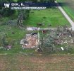
Sheriff identifies 2 victims killed in Jefferson County, Ill. due to reported tornado
A reported tornado is to blame for two deaths and five injuries in Jefferson County, Illinois, on Sunday, June 21.
 www.kfvs12.com

- Thread starter
- #336
Kds86z
Member
Wow! That's impressive. Low end ef4?
- Thread starter
- #338
Kds86z
Member
Doubt it? May be a mobile home too?Wow! That's impressive. Low end ef4?
- Thread starter
- #339
Kds86z
Member

Brad Arnold says he may go chase today in Alabama. Says there could be a few tornadoes