
Oh that's not good. I did see a large CC drop in that earlier but I wasn't expecting anything to that level of severity. This whole event has been nothing but surprises and a definite learning experience. Mother nature has a way of humbling you up when you get to confident.
Navigation
Install the app
How to install the app on iOS
Follow along with the video below to see how to install our site as a web app on your home screen.
Note: This feature may not be available in some browsers.
More options
-
Welcome to TalkWeather! We see you lurking around TalkWeather! Take the extra step and join us today to view attachments, see less ads and maybe even join the discussion. CLICK TO JOIN TALKWEATHER
You are using an out of date browser. It may not display this or other websites correctly.
You should upgrade or use an alternative browser.
You should upgrade or use an alternative browser.
Severe WX Severe Weather Thread - 6/15/26 - 6/18/26
- Thread starter WeathermanLeprechaun
- Start date
DanLarsen34
Member
There was never a confirmed tornado in that part of the state from what I recall, although the couplet looked decent as it approached Walworth earlier.
OHWX97
Member
I won't even consider sleep until that cell just east of Greensburg, IN dissipates. That's headed my way if it stays on course. Same one that produced the Stinesville tornado, I believe.Yeah I feel you there. I'd stay vigilant but things seem to be winding down now.
Back when I lived in Dayton I was up all night during the 2023 outbreak watching the cyclical Robinson/Sullivan cell get closer and closer. Thankfully it fell apart as it got close but that was a loooong nerve wracking night.
Certainly some scary nights around here over the years. May 27, 2019. March 2, 2012.
Was that the one that crossed into Wisconsin from Iowa, or was it another one down the line?Oh that's not good. I did see a large CC drop in that earlier but I wasn't expecting anything to that level of severity. This whole event has been nothing but surprises and a definite learning experience. Mother nature has a way of humbling you up when you get to confident.
N0mz
Member
One last thing: could get a nice little event in New England if something manages to stay discrete. 3cape and 3k srh are great, although thermos are very very marginal. But as we have seen today, anything in 500 srh is workable. Would not be surprised to see a 5# added on the i91 corridor over Hartford/Springfield/Keene.
DanLarsen34
Member
That would be great, but I think it might be a little early still given how wooded the area is and the fact that this happened at night. There was a report earlier that the stretch of the interstate near the area impacted by the tornado was closed for 12 consecutive exits, so I’m not sure we’re going to have a great picture of what happened out of the entire damage path until tomorrow.Damage from the earlier rain-wrapped tornado in Charleston is lower end thankfully. Looks like roof damage and downed trees and power lines for the most part.
DanLarsen34
Member
This was the last warning that occurred in Wisconsin before it crossed into Illinois. Walworth is to the east of Janesville.Was that the one that crossed into Wisconsin from Iowa, or was it another one down the line?
Jacob Aden
Member
There’s going to be a prolific tornado outbreak in the southeast because of Arthur as well.One last thing: could get a nice little event in New England if something manages to stay discrete. 3cape and 3k srh are great, although thermos are very very marginal. But as we have seen today, anything in 500 srh is workable. Would not be surprised to see a 5# added on the i91 corridor over Hartford/Springfield/Keene.
OHWX97
Member
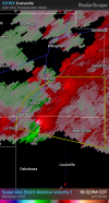
Persistent meso with this one. Seems to be attempting to tighten up near Riley, IN.Very strong meso on this cell near Marshal.
View attachment 53654
Fair. I'm basing this off of daytime damage imagery though. Worst I've seen is heavy roof damage to buildings, but there could be some nastier damage that has yet to be seen.That would be great, but I think it might be a little early still given how wooded the area is and the fact that this happened at night. There was a report earlier that the stretch of the interstate near the area impacted by the tornado was closed for 12 consecutive exits, so I’m not sure we’re going to have a great picture of what happened out of the entire damage path until tomorrow.
Wow, my friend is in Janesville. He's had so many close calls the past few years.This was the last warning that occurred in Wisconsin before it crossed into Illinois. Walworth is to the east of Janesville.
cincywx
Member
I won't even consider sleep until that cell just east of Greensburg, IN dissipates. That's headed my way if it stays on course. Same one that produced the Stinesville tornado, I believe.
Pretty much my train of thought with that southern cell. I have a hard time believing it will even be at severe limits by the time it reaches the metro because of the rain (as you pointed out earlier), but there's not going to be any sleeping until I can be sure of that. Considering it's still slow to get rid of its comma head, that confidence probably won't come until it's in the metro.
jiharris0220
Member
Today was an important reminder that with enough sheer, tornadoes are close to guaranteed.One last thing: could get a nice little event in New England if something manages to stay discrete. 3cape and 3k srh are great, although thermos are very very marginal. But as we have seen today, anything in 500 srh is workable. Would not be surprised to see a 5# added on the i91 corridor over Hartford/Springfield/Keene.
Ive been a broken record saying this but I will say it again, high vertical instability ceases to be needed in extreme sheer set ups. You can have 100j/kg cape values with laspe rates at 5c/km and still easily get a long track violent tornado to occur.
Once helicity values hit 600 in an environment with literally any amount of vertical instability, it becomes improbable for tornadoes NOT to occur.
Kds86z
Member
Anyone have any news from between Spencer and Morgantown, IN? That was an absolute monster but I haven't heard anything at all.
If that's real, that thing was a drill bit.
DanLarsen34
Member
I’d say, now that things have calmed down, that what just transpired was still on the low-end of what could have happened today. While it wasn’t the complete bust it looked like at 6 PM, I’d argue with the dynamics at-play that this was about what most people would have set the floor at today.
We’re incredibly lucky that the late trends from the models of the morning MCS messing with low-level instability really came to fruition given that we had a long-lived, discrete to semi-discrete mode this afternoon and evening. If things had played out a little differently, this could have been the higher-end event we were all worried about 48 hours ago.
We’re incredibly lucky that the late trends from the models of the morning MCS messing with low-level instability really came to fruition given that we had a long-lived, discrete to semi-discrete mode this afternoon and evening. If things had played out a little differently, this could have been the higher-end event we were all worried about 48 hours ago.
DanLarsen34
Member
Kds86z
Member
Wrapping up quickly..There’s a tightening velocity couplet with the storm to the south of Effingham. We might see another tornado warning shortly.