cincywx
Member

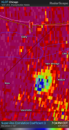
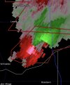
TDS grew in size after passing through Turkey Creek Meadows, IN... Hobart, IN is next in the path.
Follow along with the video below to see how to install our site as a web app on your home screen.
Note: This feature may not be available in some browsers.
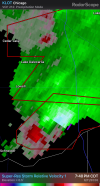
Oh yeah 100%. It's already wrapping up really really good.Storm around Shelby might start becoming the dominant one here in a bit.
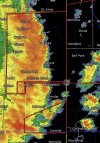
It’s looking really impressive now both on velocity and reflectivity. It may affect areas that were hit earlier this year.Storm around Shelby might start becoming the dominant one here in a bit.
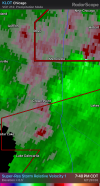
I'm in the new MD (Elkhart County IN). Did this song and dance earlier in March and got spared. Let's see if I get lucky again.New MD just got released:
SPC Update:
"
Areas affected...northwest Indiana
Concerning...Tornado Watch 313...318...
Valid 120044Z - 120215Z
The severe weather threat for Tornado Watch 313, 318 continues.
SUMMARY...A strong to intense tornado threat will exist for the next
1 to 2 hours.
DISCUSSION...A cluster of supercells across northwest Indiana has a
history of tornadoes including a likely strong tornado across Lake
County within the past 15 minutes. The southernmost storm in this
cluster across northern Newton County is exhibiting broad, strong
rotation and is in a similarly favorable tornado environment
featuring STP around 5. This supercell is expected to remain
discrete/undisturbed and will likely pose a strong to potentially
intense tornado threat across southern Porter, Laporte, and
potentially St. Joseph county for the next 1 to 2 hours."