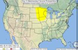
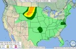
Color me a bit skeptical of Wednesday in the northern Plains as far as quality chase potential goes. SPC went through the caveats pretty well in their outlook:
While there is some model signal that the deep-layer shear vectors may only cross the surface frontal zone at a small angle, sufficient bulk shear magnitudes will exist to support supercells and bowing structures amidst potentially more complex/messy storm modes.
Sounds a lot like May 30, 2022, which 4-5 days out was being massively hyped as the next June 16, 1992 or June 17, 2010, only to trend quite sloppy.
So watch it do something spectacular, I'm probably just salty I won't be able to chase despite being on vacation; my wife and I will be visiting family in Ohio Tuesday-Friday of next week.