• Welcome to TalkWeather!
    We see you lurking around TalkWeather! Take the extra step and join us today to view attachments, see less ads and maybe even join the discussion.
    CLICK TO JOIN TALKWEATHER

Severe Weather Threat 4/27-4/28

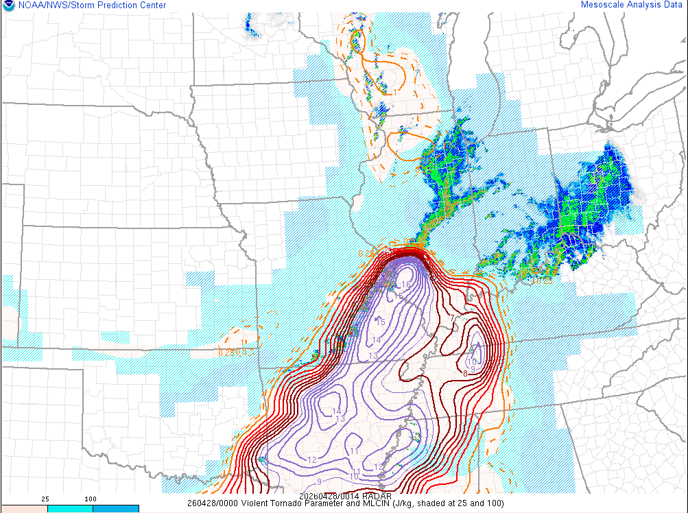
The way this event has played out is extremely head-scratching to me. Models completely botched this, like so badly it's not even funny. This event is still not over but goodness gracious, there's model misses and then there's whatever this is.

EDIT: The northern line depicted on the HRRR was actually very solid, though.
 
Not saying the event is over by any means, but I think we’re seeing now that it was smart for the SPC to hold off on CIG3 and/or high risk, despite an extremely impressive parameter space on paper.
Honestly, I see why they were so bearish and kept this as enhanced for so long.

Maybe the LLJ Ramps things up, but I’ve really not seen anything from this environment today, regardless of high STP, be conducive to tornadogenesis.
 
It's extremely funny that the actual threat to busting is just a total lack of convection instead of overconvection. Kinda baffled by how much the HRRR messed this up not only significantly but in pretty much every single run it had.
 
LOL

Screenshot-2026-04-27-191835.png
 
So, what did I miss? Other than absolutely f$*k all?
On a serious note, the only chance left of any tornadoes occurring at all are the three supercells in south central Missouri highlighted here.
They are in a primed environment, if they don’t produce, then this day will be remembered as for what happens when surface winds aren’t backed, models severely overestimating the forcing mechanism, underestimating the inversion layer and one of the biggest, if not the biggest b#st of a moderate risk recorded.
 
It's extremely funny that the actual threat to busting is just a total lack of convection instead of overconvection. Kinda baffled by how much the HRRR messed this up not only significantly but in pretty much every single run it had.
That makes me wonder if there were any models that suggested something like this happening...
 
So, what did I miss? Other than absolutely f$*k all?
On a serious note, the only chance left of any tornadoes occurring at all are the three supercells in south central Missouri highlighted here.
They are in a primed environment, if they don’t produce, then this day will be remembered as for what happens when surface winds aren’t backed and one of the biggest, if not the biggest b#st of a moderate risk recorded.


Jinx

Calling it now...

Wait for it...


Wait...


BUST
First to call high risk, first to call bust. You know what? I respect it.
 
Not saying the event is over by any means, but I think we’re seeing now that it was smart for the SPC to hold off on CIG3 and/or high risk, despite an extremely impressive parameter space on paper.
Honestly, I see why they were so bearish and kept this as enhanced for so long.

Maybe the LLJ Ramps things up, but I’ve really not seen anything from this environment today, regardless of high STP, be conducive to tornadogenesis.
It's almost like the people making these decisions are some of the smartest people in the world, and we're just some weather dweebs behind a keyboard.
 
Back
Top