• Welcome to TalkWeather!
    We see you lurking around TalkWeather! Take the extra step and join us today to view attachments, see less ads and maybe even join the discussion.
    CLICK TO JOIN TALKWEATHER

Severe Weather 3-25

Sounding-wise, NW OH seems to be the most potent, with an STP of >5 and CAPE close to 2,000 J/kg. The IN and IL threat doesn't seem as serious.
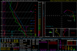
1774552726056.png


Judging by the outlook, I'm pretty sure they'll issue this watch for areas from Charleston up to Fort Wayne and leave out areas of Warsaw IN northward. Can't see them issuing it around my areas since their confidence for tornadoes is very slim to none due to the front movement.
 
VERTICAL VORTICITY NEAR THE LAKE BREEZE BOUNDARY
COULD ALSO SUPPORT A LOCALLY GREATER TORNADO RISK GIVEN FAVORABLE
STORM MOTIONS PARALLEL TO THE LAKE SHORE.

RECENT CAM GUIDANCE AND SATELLITE TRENDS REGARDING THE ONGOING
SHALLOW CONVECTION/SHOWERS OVER NORTHWEST OH AND LOWER MI SHOW THEM
GRADUALLY DEEPENING AS CONTINUED HEATING AND MID-LEVEL ASCENT ERODE
INHIBITION. THIS SHOULD SUPPORT AN INCREASE IN THE SEVERE RISK LATE
THIS AFTERNOON INTO THE EVENING. A TORNADO WATCH WILL LIKELY BE
NEEDED.

 
Back
Top