
Navigation
Install the app
How to install the app on iOS
Follow along with the video below to see how to install our site as a web app on your home screen.
Note: This feature may not be available in some browsers.
More options
-
Welcome to TalkWeather! We see you lurking around TalkWeather! Take the extra step and join us today to view attachments, see less ads and maybe even join the discussion. CLICK TO JOIN TALKWEATHER
You are using an out of date browser. It may not display this or other websites correctly.
You should upgrade or use an alternative browser.
You should upgrade or use an alternative browser.
Severe Weather 3/15 - 3/16
- Thread starter CheeselandSkies
- Start date
kcyalater
Member
and here.::: we :::: go.
douglas county MO kicks off what is going to be a very, very long 24 hours.
douglas county MO kicks off what is going to be a very, very long 24 hours.
WhirlingWx
Member
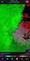
I thought it would wrap up more on velocity after this frame but looks like it's behaved for now.Also looking S of Warrenton, MO (closer to the St. Louis metro) as an area of storms potentially wrapping up
Attachments
Kds86z
Member
David Miller
Member
A lot of sun breaking through the clouds over in the W TN area, you can feel the instability here.
tornado examiner
Member
Ignore this. My bad.
Last edited:
Do you have model guidances saying this?Who else thinks tomorrow’s tornado threat is being drastically overblown? It’s very conditional and will likely not go high risk. Not even for wind.
19z hrrr casually spitting out beefy supercells in south Mississippi
cg9450
Member
Everybody gangsta until they’re asked for model guidanceDo you have model guidances saying this?
KakashiHatake2000
Member
Matthew cappucci made a post on Facebook sounding the alarm if you will for tommorrow with great concern but that’s not to take away with today’s threat
tornado examiner
Member
I’ve seen others point things out. Saying it’s not high risk material.Do you have model guidances saying this?
I’m not really saying anything conclusive just what I’ve been observing. I don’t really view models myself. It’s why I’m asking.
KakashiHatake2000
Member
High risk or not still something to take seriously for tomorrow
No, he does this before every event. Just ignore it.Do you have model guidances saying this?
No one is saying tomorrow is a 3/31/23, 3/14-3/15 level event at all.
While no forecast is ever guaranteed, pretty much all indications are that the threat tomorrow is rather substantial, and particularly rare for the Mid-Atlantic. Tornado risk will exist within the QLCS, which is likely to cellularize with time, not to mention possible pre-frontal convection. From the standpoint of the SPC forecast, I don't think it's overblown at all - a 15% with CIG1 hatching seems more than adequate given what we know the environment will be like tomorrow.Who else thinks tomorrow’s tornado threat is being drastically overblown? It’s very conditional and will likely not go high risk. Not even for wind.
speedbump305
Member
No matter what, I have heard from very trust worthy people that have expressed concerns about the tornado threat. Such as Gabe Garfield. That alone is enough to have me concerned about tomorrow. Plus, regardless if it goes HIGH or not, we are not the experts and we leave that up to the SPC and it’ll still be a very dangerous situation regardless as the parameter space is very good.I’ve seen others point things out. Saying it’s not high risk material.
I’m not really saying anything conclusive just what I’ve been observing. I don’t really view models myself. It’s why I’m asking.
Jason Mills
Member
I've been looking at the 19z HRRR and some of the other CAMs over SE AL (where I live). I know it was mentioned earlier today, but I can't find the post or otherwise I'd quote it.
I have noticed a little bit of an uptick in the projected updraft helicity values over this region, but they have been otherwise fairly anemic.
The projected environment is still very volatile and it still kind of amazes me that we're pulling these types of numbers at 2,3,4 AM in mid-March, but the overall lack of updraft helicity is telling us something.
This sounding is from the 19z HRRR over south/central AL. I've drawn in the SR wind vectors (yellow) and the vorticity vectors (yellow) for the lowest ~3km. There is a fairly high ratio of crosswise to streamwise vorticity in this layer, especially as you ascend past the very lowest level, which may make it relatively difficult to sustain a robust mesocyclone and convert that into a tornado. I did draw the vectors from the mean storm motion as opposed to the right deviant which does decrease the amount of streamwise vorticity FWIW.
In addition, SR winds are fairly weak in the 1-6km range (in the order of ~10kts) which may damper the supercellular tornado risk to some degree.
tornado examiner
Member
Do I?No, he does this before every event. Just ignore it.
No one is saying tomorrow is a 3/31/23, 3/14-3/15 level event at all.
I guess I’m just skeptical. I didn’t think it was either.
SmokeEater
Member
Huge watch out for the 10% area now. Very strong wording.
speedbump305
Member
I saw that as well. Very strong wording. I’m getting really concerned for the next couple of hours.Huge watch out for the 10% area now. Very strong wording.