• Welcome to TalkWeather!
    We see you lurking around TalkWeather! Take the extra step and join us today to view attachments, see less ads and maybe even join the discussion.
    CLICK TO JOIN TALKWEATHER

SPC Outlook Changes March 2 2026

N0mz

Member
Messages
726
Reaction score
2,596
Location
Washington, DC/Boston, MA
https://www.spc.noaa.gov/exper/conditional-intensity-information/

The SPC just announced they're making significant updates to d1/d2/d3 outlets that will take effect MARCH 2 2026. The big change is shifting from sig/non sig hatching to <CIG1, CIG1, CIG2, CIG3 hatching. Basically no hatch/single hatch/double hatch/triple hatch. They also updated the risk conversion tables to account for this change:

EDIT: forgot to mention that 90 and 75 contours were added for wind risks
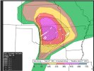
Screenshot 2026-01-29 at 3.19.22 PM.png

Example outlook:
1769718007278.png
 
Last edited:
I was under the impression that the hatched "levels" they were adding were a rumor.

One thing I do really like about this is it seems like they're finally adding back the possibility of getting a <10% hatched, which was needed. There are plenty of days on the plains that would fit this criteria - a great example of this would be a day similar to 6/20/25 (6/20/25 did end up being a 10% or 15% hatched iirc). On the other hand, though, I do think the graphic is somewhat cluttered and may be a little confusing to laymen, although I do like the word they use to describe the hatched areas; "intensity" definitely gets the point across to most people. Overall, I'd say this is a great change.

EDIT: I will say, according to the graphic, I do genuinely wonder why it is even technically possible for there to be a 60% tornado risk that is completely unhatched. There's just no way even the most tornadic QLCS or derecho could produce enough tornadoes to verify a 60% tornado risk - maybe the December derecho of '21? I'd like to know what tornado risk level would've verified on that day, because that's easily the most prolific tornado producing derecho I've ever seen.
 
Last edited:
See my edit; they added 75% and 90% wind risks. I think they should probably bump the requirement for a wind-driven high risk to at least 75% now that they have it.
Yeah, I agree - and honestly, I just cannot agree with a HIGH risk for a 45% chance of anything outside tornadoes. 75% for CIG2+ seems valid enough to me, and I suppose a 60% CIG3 for wind can justify a HIGH. But a 45% chance for CIG3 is not enough confidence to issue a HIGH in my opinion.
 
Loads think this would be confusing but imo, this will finally set so much of this "THEY SAID IT WAS GONNA HAPPEN"

Conditional days are going to be messaged so much better. Take for example, 4/27/25 in the Plains. Half of the area mightve had CIG2, and that would've meant a conditional threat, not unlikely but not out of the question for strong tornadoes. Really excited to see this used in low end days to acknowledge a dangerous threat. Simulations/analog based forecasting appears to be the future. I believe the SPC uses a inside tool that essentially simulates worst case outcomes which was used for a forecasting experiment in 2024. Some of the simulations for 3/31/23 were pretty cool, a lot of variance in the same area with long track tornadoes. I wonder if they still use that tool to get a estimate on some days.

One thing i really want to see improve if possible is sneaky sigtor days like Welfleet. I do wonder if simulations would've picked up on any sigtor in Nebraska that day. This will change public messaging a lot imo. QLCS events/bookend vortex events could also work out well. Note the 3/15 had a hatched all the way into W SC on that outlook. Hopefully they release some sort of archive to see what certain days would've looked like with this method. I would happily experiment all day.
 
I like it and have no problems with it except I would use a different color contour for the 3 hatch areas (like Black, Dark Gray, and White). I would use White for the 3rd SIG layer. That's probably the way I will go with it on my graphics.
 
Last edited:
1769804006558.png

Here is the example for the April 2nd High Risk. Interesting to see they are utilising a range of conditional probabilities even within these High-Risk setups, as I partly expected them to almost automatically issue the CIG3 category for High Risks given the dangerous nature of those setups.
 
View attachment 50453

Here is the example for the April 2nd High Risk. Interesting to see they are utilising a range of conditional probabilities even within these High-Risk setups, as I partly expected them to almost automatically issue the CIG3 category for High Risks given the dangerous nature of those setups.
Did you get this from a file or website? Very interesting that they chose CIG2 on this, but understandable given the conditional nature of the prefrontals
 
If y'all notice too, SPC will not have the probability of tornado/wind/hail within 25 miles of a point anymore
 
View attachment 50453

Here is the example for the April 2nd High Risk. Interesting to see they are utilising a range of conditional probabilities even within these High-Risk setups, as I partly expected them to almost automatically issue the CIG3 category for High Risks given the dangerous nature of those setups.
Do you have any of these for wind? I'd like to know what the 75% and 90% colors are.
 
View attachment 50453

Here is the example for the April 2nd High Risk. Interesting to see they are utilising a range of conditional probabilities even within these High-Risk setups, as I partly expected them to almost automatically issue the CIG3 category for High Risks given the dangerous nature of those setups.
Apologies, I just seen the tweet where it's shown
 
I'm not sure we'll know what the new colors for the wind probabilities will be until a couple days before or the day they issue the new setup.
 
If y'all notice too, SPC will not have the probability of tornado/wind/hail within 25 miles of a point anymore
So do you have any information on what the probabilities will correspond to instead (e.g. probability of an event within 10 miles of a point instead of 25 miles)? I think that would be useful in understanding how to interpret the new probability scales.
 
I don't, but I interpret it like here's today's 15% conditional intensity probability for your general area. To be honest, I really didn't use the within 25 miles of your location until a couple years ago. And who even looks at that too. Most people including myself would interpret a probability from SPC as for all of North MS, Central AL, Central MS, etc. (if there were different probabilities used, then we would say a 2% TOR Risk extends from this county/city to here and the 5% extends to here/here) I mean, even if SPC isn't doing the within miles anymore, the meteorologist on TV or something could determine/set a mile radius their selves now for their viewing area if they wanted to.
 
Last edited:
March 15, 2025 example:
1770137968841.png
I guess I could see this being more useful, but I honestly think it over-complicates an already-complicated map. While weather enthusiasts are going to easily decode and use this, I think the general public might have issues with all the hashes, dotted lines and grids. Put that on top of the color map and it's just a mess of lines and shapes. I dunno. Probably am the minority here.

What I think would work best is having a tab on the outlook site that isolates the intensity levels (CIG1/CIG2/CIG3) from the probability map, so that it's easier to look at. Sort of like this, but replace the "tornado, wind, hail" tabs with "CIG 1, CIG 2, CIG 3". Maybe add a checkbox that lets people optionally add the probability maps.
 
Last edited:
March 15, 2025 example:
View attachment 50507
I guess I could see this being more useful, but I honestly think it over-complicates an already-complicated map. While weather enthusiasts are going to easily decode and use this, I think the general public might have issues with all the hashes, dotted lines and grids. Put that on top of the color map and it's just a mess of lines and shapes. I dunno. Probably am the minority here.

What I think would work best is having a tab on the outlook site that isolates the intensity levels (CIG1/CIG2/CIG3) from the probability map, so that it's easier to look at. Sort of like this, but replace the "tornado, wind, hail" tabs with "CIG 1, CIG 2, CIG 3". Maybe add a checkbox that lets people optionally add the probability maps.
But the general public isn't looking at the SPC outlooks. It is up to the news networks when presented with the outlook to message it as clearly as possible. This makes the potneital of outlining the potential for most damaging tornadoes.

With high risks, it was usually "This is the area where EF3+ tornadoes is possible" but now we can message risks below that if the SPC sees the potential in it. Eastern GA stations would have to message on this outlook "There is a very low chance of a tornado BUT the Storm Prediction Center sees the potential for a strong tornado." it makes conditional risks easier to message. They can acknowledge probability/intensity all in one. We will see how the public responds but it is mostly up to news stations to make this understandable to them.
 
I agree, I don't think this is a positive step from a public messaging perspective. Then again, most of the public isn't weather weenies who are going directly to the SPC site for their weather information.
That second part is pretty much my thoughts. Also can't news stations just outline the CIG except use "EF2+" "EF3+" "EF4+"? They can translate the CIG to what intensity is most likely. Now for wind and hail, it's probably gonna be more confusing but i just think outlining the intensity instead of the specific CIG level would help messaging so much better.
 
But the general public isn't looking at the SPC outlooks. It is up to the news networks when presented with the outlook to message it as clearly as possible. This makes the potneital of outlining the potential for most damaging tornadoes.
The general public does look at SPC outlooks - if they didn't, news outlets like WHNT wouldn't be reporting on the change. It's not the operational aspect (obviously it'll be helpful), just how it's presented to the public. Regardless of who reads it, the outlooks should still be readable to a wide audience (the synopses aren't readable to 90% of people anyways, so your best bet on conveying a threat is via the graphic). The government is for the people, after all.
 
Back
Top