
The position of where the 2nd low pressure forms is very favorable for parts of the deep south on the NAM. If it rapidly deepens as it ejects northeast.. watch out!
Navigation
Install the app
How to install the app on iOS
Follow along with the video below to see how to install our site as a web app on your home screen.
Note: This feature may not be available in some browsers.
More options
-
Welcome to TalkWeather! We see you lurking around TalkWeather! Take the extra step and join us today to view attachments, see less ads and maybe even join the discussion. CLICK TO JOIN TALKWEATHER
You are using an out of date browser. It may not display this or other websites correctly.
You should upgrade or use an alternative browser.
You should upgrade or use an alternative browser.
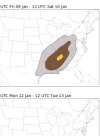
Severe Weather Threat January 8-10, 2026
- Thread starter CheeselandSkies
- Start date
akt1985
Member
Day 2 and 3 Marginal Risks are out this morning for the southern Plains.
Trey says he expects widespread all hazards risk Friday.
- Thread starter
- #84
CheeselandSkies
Member
Trey says he expects widespread all hazards risk Friday.
I'm at work so I haven't had time to look in depth yet, but that sounds considerably more bullish than the hot takers on X yesterday (which included at least one veteran chaser from my generation who really ought to know better than to do that 4-5 days out).
He said he's going to make a video or live video tommrow* on the multi day threat.I'm at work so I haven't had time to look in depth yet, but that sounds considerably more bullish than the hot takers on X yesterday (which included at least one veteran chaser from my generation who really ought to know better than to do that 4-5 days out).
Last edited:
WeathermanLeprechaun
Member
WeathermanLeprechaun
Member
NAM actually says maybe not a full QLCS but still some semi discrete-linear potential. Kinematics are significantly stronger but still even some instability issues where strongest LLJ is. That would still provide a low end, brief tornado risk either way
Semi discreet QLCS sounds about like the status quo for the south in the winter for tornadoes lol ;pNAM actually says maybe not a full QLCS but still some semi discrete-linear potential. Kinematics are significantly stronger but still even some instability issues where strongest LLJ is. That would still provide a low end, brief tornado risk either way
Trying to remember a event in January that Alabama recently went through with some tornadoes, January 12, 2023 comes to mind. The surface low wasn't overly deep very similar to this forecasted one
Looks increasingly like this will be split up into two days - the higher threat clearly on Friday across the MSV. Going to focus on Saturday here. For Alabama and Georgia folks, GFS suggests there will be instability sticking around all the way through the morning hours, which may intensify some with diurnal heating on Saturday afternoon. There will be plenty of moisture in place, courtesy of our first of two lows which jostles up Gulf moisture without scouring it, ahead of our secondary low. There'll be an LLJ in place Saturday morning, which will be lifting off to the north as the day progresses, meaning increasingly marginal kinematic profiles. Based off NAM guidance and depiction on the GFS, taken verbatim, it looks like a cluster/scattered event over parts of the MSV will transition into a more typical QLCS over Alabama and Georgia. I reckon the biggest threat will be straight-line winds, even moreso the further east you go. Nevertheless, some QLCS tornadoes are definitely possible. Soundings are near Birmingham, AL and Cedartown, GA, respectively; the latter comes from the 06Z run, which is a little slower and has stuff coming into NW GA over the evening. Overall, not particularly concerning for folks east of the MSV, standard fare QLCS threat, but looking westward, could definitely see some problems in parts of LA, AR and MS.


WeathermanLeprechaun
Member
Being realistic, the surface low is not always the main basis for Dixie events. 1/12/23 featured stronger backing than expected, and some instability uptrend. That event was a bit more of a day of build upTrying to remember a event in January that Alabama recently went through with some tornadoes, January 12, 2023 comes to mind. The surface low wasn't overly deep very similar to this forecasted one
Yep. On surface low placement, while it’s very important, if other factors are present, they can compensate for that. Look at 4/2/25 last year with the surface low that far north around Minnesota.Being realistic, the surface low is not always the main basis for Dixie events. 1/12/23 featured stronger backing than expected, and some instability uptrend. That event was a bit more of a day of build up
That is something I thought incorrectly about for years, that the surface low needed to be in very close proximity to the outbreak region. As long as there are pressure falls to back the low-level winds ahead of the front, as well as height falls aloft, low location doesn't always matter. If you still have a catalyst to cause pressure falls and large scale ascent aloft, placement isn’t a make or break.
This is different than the situation we are discussing for Friday, but it’s something I learned last year after reading up on the 4/2 event since I would almost write events off if they weren’t in near proximity to the surface low.
Kds86z
Member
From NWS Shreveport
This raises the question with regard to severe
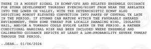
weather. Instability looks to continue to be the limiting factor (as does overall dynamical forcing being displaced well to the north), with MLCAPE and SBCAPE appearing to remain around 500J/kg at best, and possibly capped through much of the afternoon. This said, shear parameters will be sufficient for updraft organization and should thunderstorms develop, and this combined with 0-3km helicity values above 2000m2/s2, per model guidance, modest mid level lapse rates close to 7C/km, severe weather cannot be ruled out, including large hail and a tornado or two. The SPC currently reflects a marginal risk for severe weather across the area on Thursday.
The isolated severe thunderstorm threat cannot be ignored Thursday night into Friday as a surface cold frontal boundary approaches and a jet streak rounds the base of yet another area of mid/upper level low pressure moving across the Desert SW towards the Southern Rockies. While time of day is not necessarily conducive to severe weather, and most SBCAPE will likely no longer be present, any elevated thunderstorms, supported by marginal MUCAPE, could pose a threat for some wind and hail.
Friday currently carries the higher threat for rainfall and severe thunderstorm chances. The cold front will be slowly pushing SE across the area through the day. This time, the approaching shortwave trough across the Southern Rockies and into the Southern Plains will be in a more favorable position for influence. PVA ahead of the trough, combined with daytime heating is expected to ignite convection along the frontal boundary, and likely also ahead within the broader warm sector. The afternoon and evening hours appear to provide a window of opportunity where MLCAPE values will reach at least 1000J/kg along and ahead of the boundary, and this combined with efficient shear profiles and lift could lend a decent chance for strong to severe thunderstorm development. The question will be where the cold front is located as we move into Friday afternoon and whether the upper level support will maintain current projected timing and spatial trends. While it currently appears some of the more favorable parameters for large hail and tornadoes are less impressive, it still remains a bit early to speculate specific severe weather hazards.
Last edited:
KakashiHatake2000
Member
did i read that right 2000 m2/s2 two thousand m2/s2 holy moly guacamoly
Kds86z
Member
Caught my eye too, .. mistake?did i read that right 2000 m2/s2 two thousand m2/s2 holy moly guacamoly
KakashiHatake2000
Member
hopefully so
Kds86z
Member
cheestaysfly
Member
That is right over my area. Better start readying my go-bag. I'll always be so thankful I have a tornado shelter in my backyard.Guidance downtrended somewhat on the NCAR ensembles. Not much of a 15% contour. Still thinking linear QLCS event is the game here as we get into the NAM range