Navigation
Install the app
How to install the app on iOS
Follow along with the video below to see how to install our site as a web app on your home screen.
Note: This feature may not be available in some browsers.
More options
-
Welcome to TalkWeather! We see you lurking around TalkWeather! Take the extra step and join us today to view attachments, see less ads and maybe even join the discussion. CLICK TO JOIN TALKWEATHER
You are using an out of date browser. It may not display this or other websites correctly.
You should upgrade or use an alternative browser.
You should upgrade or use an alternative browser.
Potential Tropical Cyclone Nine and Hurricane Humberto
- Thread starter wx_guy
- Start date
Psalm 148:8
Member
Yall keep the info coming., got a niece and family at Parris Island, SC.. she said they may have to evacuate.. did not hear where she got this info.. edit.. military planning dept. monitoring the storms.
I’m in central Virginia and I need to watch this as well. Not often I get a TC because of the mountains to the west, so storms that pack a punch well inland need to come from the southeast like this one may do.Yall keep the info coming., got a niece and family at Parris Island, SC.. she said they may have to evacuate.. did not hear where she got this info.. edit.. military planning dept. monitoring the storms.
Kds86z
Member
I think my friends are going to their beach house in north Carolina next week @Atlantic . I’ll never understand why it’s always September lol during hurricane season. Feel like a lot of people don’t think about it though.I’m in central Virginia and I need to watch this as well. Not often I get a TC because of the mountains to the west, so storms that pack a punch well inland need to come from the southeast like this one may do.
Kds86z
Member
Because then you could get caught in evacuation traffic and all that etc. yeah no thanks, if I did vacations along coast it wouldn’t be Aug/octI think my friends are going to their beach house in north Carolina next week @Atlantic . I’ll never understand why it’s always September lol during hurricane season. Feel like a lot of people don’t think about it though.
If it pans out to it moving inland over the east coast, you might get some of its remnants, but I’ll potentially get it as a TS or TD.I think my friends are going to their beach house in north Carolina next week @Atlantic . I’ll never understand why it’s always September lol during hurricane season. Feel like a lot of people don’t think about it though.
This is all leaning on if it goes inland or not, because if it goes OTS, we will probably get nothing from it.
Kds86z
Member
Yeah too early yetIf it pans out to it moving inland over the east coast, you might get some of its remnants, but I’ll potentially get it as a TS or TD.
This is all leaning on if it goes inland or not, because if it goes OTS, we will probably get nothing from it.
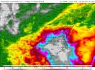
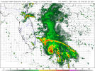
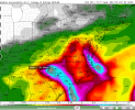
6 inches of rain for me in this run.It's not too early for folks to start talking about the potential amount of water coming. Ugly output from 12Z euro.
View attachment 46675
18ZGFS is Imelda into the NC/SC border area, then its moisture sucked back out to Humberto via NE NC.
akt1985
Member
The dreaded I named storm. Hopefully Imelda won’t wind up joining the list of I named storms that got its name retired.
It should have been kicked out of the house back in 2019 tbh after all of the flooding it caused.The dreaded I named storm. Hopefully Imelda won’t wind up joining the list of I named storms that got its name retired.
Jacob Aden
Member
Models have trended down a bit intensity-wise because Imelda takes so long to consolidate, not sure I buy it. Regardless, conditions are very favorable for intensification in the Bahamas.
Jacob Aden
Member
Given that the effects of the gulf stream are well known to enhance hurricanes, and knowing that the models take that into account only slightly, I fear a scenario the models are missing, and that being Imelda asserting dominance in the interaction due to RI over the gulf stream, causing Humberto to rotate counterclockwise around and not pull Imelda out as quickly. Not making a prediction, but as someone who has watched systems RI in the stream, that's a thought I want to have recorded ahead of time.
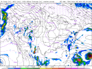
This (similar strength H&I):
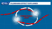
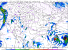
Instead of this (H stronger than I, currently modeled, H vampiring I's moisture as I makes landfall):
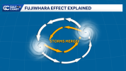
(credit to Sara Blue and Gulf Coast News for the graphics and excellent article on fujiwhara)

 www.gulfcoastnewsnow.com
This (similar strength H&I):

Instead of this (H stronger than I, currently modeled, H vampiring I's moisture as I makes landfall):

(credit to Sara Blue and Gulf Coast News for the graphics and excellent article on fujiwhara)

Dancing Hurricanes: What is the Fujiwhara effect?
When two hurricanes glide close to each other, they can spin around in a stormy duet.
Last edited:
Yep. These are situations where the utility of models are particularly challenged by the sheer number of confounds present. Either way, I'm worried for the Carolinas, but hoping for the best.Given that the effects of the gulf stream are well known to enhance hurricanes, and knowing that the models take that into account only slightly, I fear a scenario the models are missing, and that being Imelda asserting dominance in the interaction due to RI over the gulf stream, causing Humberto to rotate counterclockwise around and not pull Imelda out as quickly. Not making a prediction, but as someone who has watched systems RI in the stream, that's a thought I want to have recorded ahead of time.
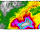
This (similar strength H&I):
View attachment 46679
Instead of this (H stronger than I, currently modeled, H vampiring I's moisture as I makes landfall):
View attachment 46680
(credit to Sara Blue and Gulf Coast News for the graphics and excellent article on fujiwhara)

Dancing Hurricanes: What is the Fujiwhara effect?
When two hurricanes glide close to each other, they can spin around in a stormy duet.www.gulfcoastnewsnow.com

