wx_guy
Member
- Messages
- 1,204
- Reaction score
- 4,327
- Location
- United States
- HAM Callsign
- KO4ZGH
- Special Affiliations
- SKYWARN® Volunteer
- ARRL Member
Follow along with the video below to see how to install our site as a web app on your home screen.
Note: This feature may not be available in some browsers.
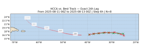
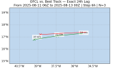
And intensity errors so far (not very helpful since it's a minimal tropical storm, but still...)
View attachment 45939
View attachment 45940
And the GFS for reference --
View attachment 45941
The lower intensity may help it skirt further west and south. We'll have to see.
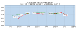
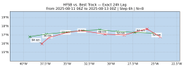
How much of an error in this stage of a TC is really “significant”?Here's the HAFS-A and HAFS-B 48-hour errors. These models have been doing mostly well on the storm so far.
View attachment 45936
View attachment 45937
And the GFS for reference --
View attachment 45938
Great question, and I'd love for any mets on the forum to reply. In my view, it's more about watching trends and seeing if there's a pull one way or another versus the models.How much of an error in this stage of a TC is really “significant”?

*crickets* Seems like excitement over Erin has totally died out lol curious to what the next few days shows. I'll post more soon.
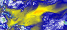
fun fact that i thought i would share im not sure if you could do this on any other app like radar scope or radar omega but on weather wise with looking at the satellite you can put it into motion so how cool is that i just thought it was too neat to share you do have to use mesoscale 1 which is only looking a rectangle shaped view of a tropical systemView attachment 45961
I've been disinterestedly checking on Erin from time to time today. A mid-level moisture vs dry air slugfest. Really depends on how that all mixes out - right now the pocket of dry is being squeezed from two sides, so moistening. A tough time firing convection, but a well defined swirl on vis all day.
fun fact that i thought i would share im not sure if you could do this on any other app like radar scope or radar omega but on weather wise with looking at the satellite you can put it into motion so how cool is that i just thought it was too neat to share you do have to use mesoscale 1 which is only looking a rectangle shaped view of a tropical system

Yeah, good point. Until we get to Friday or Saturday, the story will probably look a lot of the same between now and then.View attachment 45961
I've been disinterestedly checking on Erin from time to time today. A mid-level moisture vs dry air slugfest. Really depends on how that all mixes out - right now the pocket of dry is being squeezed from two sides, so moistening. A tough time firing convection, but a well defined swirl on vis all day.
oh cool and oh yeah absolutely thank you blountwolf i am on a laptopI think you'll find this better used on a computer.
https://weather.cod.edu/satrad/?parms=global-atlantic-09-24-1-100-1&checked=map&colorbar=undefined
This assumes you are on desktop, not a phone. Totally free.
They also have a close-up floater on Erin.

COD NEXLAB: Satellite and Radar
Check out COD Meteorology's Satellite and Radar Dataweather.cod.edu
It definitely seems like this storm has an Erin to run, as it is speeding off to just south of due west.
