Bismarck could get rocked by that MCS.
WUUS53 KBIS 210158
SVRBIS
NDC015-029-059-065-210300-
/O.NEW.KBIS.SV.W.0056.250621T0158Z-250621T0300Z/
BULLETIN - EAS ACTIVATION REQUESTED
Severe Thunderstorm Warning
National Weather Service Bismarck ND
858 PM CDT Fri Jun 20 2025
The National Weather Service in Bismarck has issued a
* Severe Thunderstorm Warning for...
Burleigh County in south central North Dakota...
Morton County in south central North Dakota...
Southern Oliver County in south central North Dakota...
Northwestern Emmons County in south central North Dakota...
* Until 1000 PM CDT.
* At 857 PM CDT, severe thunderstorms were located along a line
extending from near Center to 13 miles northwest of Mandan to near
St. Anthony to 9 miles west of Solen, moving east at 70 mph.
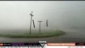
THESE ARE DESTRUCTIVE STORMS FOR SOUTH CENTRAL NORTH DAKOTA,
INCLUDING BISMARCK AND MANDAN.
HAZARD...80 mph wind gusts and quarter size hail.
SOURCE...Radar indicated.
IMPACT...Flying debris will be dangerous to those caught without
shelter. Mobile homes will be heavily damaged. Expect
considerable damage to roofs, windows, and vehicles.
Extensive tree damage and power outages are likely.
* Locations impacted include...
Bismarck, Mandan, Lincoln, Wilton, Hazelton, Flasher, Menoken,
Wing, Sterling, Regan, St. Anthony, Driscoll, Judson, Mckenzie,
Baldwin, Hazelton Recreation Area, University Of Mary, Huff, Crown
Butte Lake, and Moffit.
PRECAUTIONARY/PREPAREDNESS ACTIONS...
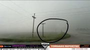
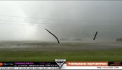
Remain alert for a possible tornado! Tornadoes can develop quickly
from severe thunderstorms. If you spot a tornado go at once into the
basement or small central room in a sturdy structure.
This is an EXTREMELY DANGEROUS SITUATION with tornado like wind
speeds expected. Mobile homes and high profile vehicles are
especially susceptible to winds of this magnitude and may be
overturned. For your protection move to an interior room on the
lowest floor of a building. These storms have the potential to cause
serious injury and significant property damage.
A Tornado Watch remains in effect until 300 AM CDT for south central
North Dakota.
&&
LAT...LON 4663 10129 4688 10137 4706 10164 4716 10085
4716 10075 4717 10075 4717 10011 4698 10011
4698 10007 4665 10008 4639 10019 4638 10056
4643 10060 4641 10069 4638 10072 4640 10074
4639 10088 4641 10088 4638 10093 4637 10129
TIME...MOT...LOC 0157Z 260DEG 59KT 4709 10134 4693 10113 4666 10096
4638 10100
TORNADO...POSSIBLE
THUNDERSTORM DAMAGE THREAT...DESTRUCTIVE
HAIL THREAT...RADAR INDICATED
MAX HAIL SIZE...1.00 IN
WIND THREAT...RADAR INDICATED
MAX WIND GUST...80 MPH
$$
HOLLAN