eric11
Member
- Messages
- 322
- Reaction score
- 779
- Location
- Shanghai,China
- Special Affiliations
- SKYWARN® Volunteer
- ARRL Member
Def the Plevna tor, then the Haviland one I thinkWhich one would you say was the strongest?
Follow along with the video below to see how to install our site as a web app on your home screen.
Note: This feature may not be available in some browsers.
Def the Plevna tor, then the Haviland one I thinkWhich one would you say was the strongest?
I think Grinnell and Plevna were the most violent of the day.Def the Plevna tor, then the Haviland one I think
oh you mean the whole outbreak, that's absolutely Grinnell and PlevnaI think Grinnell and Plevna were the most violent of the day.
oh you mean the whole outbreak, that's absolutely Grinnell and Plevna
Agreed. Grinnell and Plevna I imagine will be rated EF4. But I don’t have high hopes with Grinnell due to how the survey is lookin right now lol.oh you mean the whole outbreak, that's absolutely Grinnell and Plevna
Good times indeed! This was an interesting event to say the least.Good times yall lol
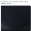
It was pretty unreal seeing a massive tornado heading right for Greensburg. I can’t even imagine the trauma the residents were facing.We won’t see it again for a while my friend! The Kansas crazy supercdll after dark
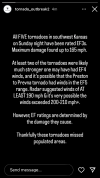
Oh my lord, just found this DI from the Grinnell survey:
View attachment 43027
This is a 112 mph EF2 DI with zero comment on how the house disappeared and instead chose to focus on damage to neighboring homes. This is one of the worst surveys I’ve ever seen.
Oh, and it gets a lot better! Here’s a 113 mph EF2 DI to the north they just added:
View attachment 43029
Is it safe to say Goodland is the most unreliable NWS office when it comes to ratings?

It was pretty unreal seeing a massive tornado heading right for Greensburg. I can’t even imagine the trauma the residents were facing.
Yeah dude. Imagine rebuilding everything and it could all be wiped away again. I’d need counseling lol
Yeah dude. Imagine rebuilding everything and it could all be wiped away again. I’d need counseling lol
Greensburg was actually almost hit again the very next day (which had a high risk in Kansas that included the Greensburg area) and on May 23, 2008.
And don’t forget Moore. Hit twice by ef5. That was crazy to watch in 2013..
Digging that new profile pic @CheeselandSkies