crandall
Member
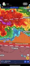
We got lucky in huntsville
Follow along with the video below to see how to install our site as a web app on your home screen.
Note: This feature may not be available in some browsers.
Spinups still possible, but straight-line winds are the main story for Georgia.Guessing that high-winds/large hail has become the main threat for the rest of the night.
As I say that, possible tornado was caught on traffic-cam in Gordon County.Spinups still possible, but straight-line winds are the main story for Georgia.

 www.wsbtv.com
We got lucky in huntsville
Velo spike in Rome on last scan - that couplet has me concerned. Could track to South Cherokee/North Cobb.Despite waning upper-level support, sufficient SRH persists in the low levels, and is in fact expanding eastward. Instability also continues to stick around. Likely will fuel these storms for some time.
View attachment 42892View attachment 42893
Old warning text459
WWUS52 KFFC 210351
SVSFFC
Severe Weather Statement
National Weather Service Peachtree City GA
1151 PM EDT Tue May 20 2025
GAC015-057-067-115-129-223-227-233-210430-
/O.CON.KFFC.SV.W.0204.000000T0000Z-250521T0430Z/
Paulding GA-Cherokee GA-Cobb GA-Floyd GA-Gordon GA-Polk GA-
Pickens GA-Bartow GA-
1151 PM EDT Tue May 20 2025
...A SEVERE THUNDERSTORM WARNING REMAINS IN EFFECT UNTIL 1230 AM EDT
FOR NORTHERN PAULDING...CHEROKEE...NORTHWESTERN COBB...SOUTHEASTERN
FLOYD...SOUTHEASTERN GORDON...POLK...PICKENS AND BARTOW COUNTIES...
At 1151 PM EDT, severe thunderstorms were located along a line
extending from near Roundtop to near Kingston to near Etna, moving
east at 40 mph.
HAZARD...60 mph wind gusts.
SOURCE...Radar indicated.
IMPACT...Expect damage to roofs, siding, and trees.
Locations impacted include...
Marietta, Canton, Cartersville, Dallas, Cedartown, Jasper, Kennesaw,
Woodstock, Acworth, Holly Springs, Adairsville, Rockmart, Euharlee,
Hiram, Emerson, Ball Ground, Nelson, Aragon, Cave Spring, and White.
PRECAUTIONARY/PREPAREDNESS ACTIONS...
A Tornado Watch remains in effect until 200 AM EDT for north central
and northwestern Georgia.
For your protection move to an interior room on the lowest floor of a
building.
&&
LAT...LON 3425 8501 3457 8480 3456 8465 3455 8465
3456 8451 3455 8449 3455 8435 3447 8432
3447 8426 3412 8437 3411 8442 3406 8442
3387 8481 3400 8541 3410 8542
TIME...MOT...LOC 0351Z 270DEG 36KT 3457 8461 3422 8491 3403 8534
TORNADO...POSSIBLE
HAIL THREAT...RADAR INDICATED
MAX HAIL SIZE...<.75 IN
WIND THREAT...RADAR INDICATED
MAX WIND GUST...60 MPH
$$
900
WUUS52 KFFC 210349
SVRFFC
GAC015-057-067-115-129-223-227-233-210430-
/O.NEW.KFFC.SV.W.0204.250521T0349Z-250521T0430Z/
BULLETIN - IMMEDIATE BROADCAST REQUESTED
Severe Thunderstorm Warning
National Weather Service Peachtree City GA
1149 PM EDT Tue May 20 2025
The National Weather Service in Peachtree City has issued a
* Severe Thunderstorm Warning for...
Northern Paulding County in northwestern Georgia...
Cherokee County in north central Georgia...
Northwestern Cobb County in north central Georgia...
Southeastern Floyd County in northwestern Georgia...
Southeastern Gordon County in northwestern Georgia...
Polk County in northwestern Georgia...
Pickens County in north central Georgia...
Bartow County in northwestern Georgia...
* Until 1230 AM EDT.
* At 1148 PM EDT, severe thunderstorms were located along a line
extending from near Roundtop to Kingston to near Etna, moving east
at 40 mph.
HAZARD...60 mph wind gusts.
SOURCE...Radar indicated.
IMPACT...Expect damage to roofs, siding, and trees.
* Locations impacted include...
Marietta, Canton, Cartersville, Dallas, Cedartown, Jasper,
Kennesaw, Woodstock, Acworth, Holly Springs, Adairsville, Rockmart,
Euharlee, Hiram, Emerson, Ball Ground, Nelson, Aragon, Cave Spring,
and White.
PRECAUTIONARY/PREPAREDNESS ACTIONS...
For your protection move to an interior room on the lowest floor of a
building.
If you see wind damage...hail or flooding...wait until the storm has
passed...and then call the National Weather Service toll free
at 1 8 6 6 7 6 3 4 4 6 6 or tweet us your report at NWSATLANTA.
A Tornado Watch remains in effect until 200 AM EDT for north central
and northwestern Georgia.
&&
LAT...LON 3425 8501 3457 8480 3456 8465 3455 8465
3456 8451 3455 8449 3455 8435 3447 8432
3447 8426 3412 8437 3411 8442 3406 8442
3387 8481 3400 8541 3410 8542
TIME...MOT...LOC 0348Z 288DEG 36KT 3458 8463 3423 8493 3404 8536
HAIL THREAT...RADAR INDICATED
MAX HAIL SIZE...<.75 IN
WIND THREAT...RADAR INDICATED
MAX WIND GUST...60 MPH
$$

BULLETIN - EAS ACTIVATION REQUESTED
Tornado Warning
National Weather Service Peachtree City GA
1154 PM EDT Tue May 20 2025
The National Weather Service in Peachtree City has issued a
* Tornado Warning for...
Northern Cherokee County in north central Georgia...
Southeastern Gordon County in northwestern Georgia...
Southern Pickens County in north central Georgia...
Northeastern Bartow County in northwestern Georgia...
* Until 1230 AM EDT.
* At 1153 PM EDT, a severe thunderstorm capable of producing a
tornado was located over Funkhouser, or 14 miles west of Jasper,
moving east at 50 mph.
HAZARD...Tornado.
SOURCE...Radar indicated rotation.
IMPACT...Flying debris will be dangerous to those caught without
shelter. Mobile homes will be damaged or destroyed.
Damage to roofs, windows, and vehicles will occur. Tree
damage is likely.
* Locations impacted include...
Jasper, Ball Ground, Nelson, Waleska, Fairmount, Salacoa Valley,
Marblehill, Talmadge, Tate, Reavis Mountain, and Funkhouser.
PRECAUTIONARY/PREPAREDNESS ACTIONS...
TAKE COVER NOW! Move to a basement or an interior room on the lowest
floor of a sturdy building. Avoid windows. If you are outdoors, in a
mobile home, or in a vehicle, move to the closest substantial shelter
and protect yourself from flying debris.
&&
LAT...LON 3447 8430 3447 8429 3438 8428 3426 8435
3437 8474 3448 8473
TIME...MOT...LOC 0353Z 273DEG 43KT 3440 8468
TORNADO...RADAR INDICATED
MAX HAIL SIZE...<.75 IN

Hopefully they got some good data out of it. Does anyone know what those small probes measure? Is it pressure?Honestly, I think this intercept scared him quite a bit. Later in the stream, he said he thought they were going to get lofted when they got hit and the vehicle started moving. He was more scared than some of the others in the vehicle. They didn’t really have time to deploy because they were still positioning for probe launch, which it sounds like was successful.
It was an incredibly intense vortex that hit them that blew up within a matter of seconds, like violent tornado intensity. That thing stayed violent for a minute or two.
One of about 5 times in the last year I thought he was about to live stream his own death. I know these guys and other chasers are pros but it’s only a matter of time before that happens. I thought Brett Adair was a goner the other night in Kansas at one point.Honestly, I think this intercept scared him quite a bit. Later in the stream, he said he thought they were going to get lofted when they got hit and the vehicle started moving. He was more scared than some of the others in the vehicle. They didn’t really have time to deploy because they were still positioning for probe launch, which it sounds like was successful.
It was an incredibly intense vortex that hit them that blew up within a matter of seconds, like violent tornado intensity. That thing stayed violent for a minute or two.
No longer quite as well-defined. BMX doesn't look to be issuing a new TOR at this time.Meso handoff seems to have occurred over Ragland, with a small, well-defined circulation now visible.
View attachment 42907
New, strong inflow is evident. Storm to its east is also intensifying.No longer quite as well-defined. BMX doesn't look to be issuing a new TOR at this time.
BULLETIN - EAS ACTIVATION REQUESTED
Tornado Warning
National Weather Service Birmingham AL
Issued by National Weather Service Peachtree City GA
1121 PM CDT Tue May 20 2025
The National Weather Service in Birmingham has issued a
* Tornado Warning for...
Central Calhoun County in east central Alabama...
* Until 1215 AM CDT.
* At 1121 PM CDT, a severe thunderstorm capable of producing a
tornado was located near Ohatchee, or 11 miles west of Saks, moving
east at 30 mph.
HAZARD...Tornado.
SOURCE...Radar indicated rotation.
IMPACT...Flying debris will be dangerous to those caught without
shelter. Mobile homes will be damaged or destroyed.
Damage to roofs, windows, and vehicles will occur. Tree
damage is likely.
* Locations impacted include...
Anniston, Jacksonville, Saks, Fort McClellan, West End-Cobb Town,
Weaver, Ohatchee, Blue Mountain, Alexandria, Neely Henry Lake, and
Choccolocco.
PRECAUTIONARY/PREPAREDNESS ACTIONS...
TAKE COVER NOW! Move to a basement or an interior room on the lowest
floor of a sturdy building. Avoid windows. If you are outdoors, in a
mobile home, or in a vehicle, move to the closest substantial shelter
and protect yourself from flying debris.
&&
LAT...LON 3377 8564 3365 8564 3363 8566 3369 8615
3371 8615 3371 8613 3373 8611 3377 8604
3380 8606 3382 8606 3378 8562 3377 8562
TIME...MOT...LOC 0421Z 274DEG 28KT 3373 8606
TORNADO...RADAR INDICATED
MAX HAIL SIZE...<.75 IN