Navigation
Install the app
How to install the app on iOS
Follow along with the video below to see how to install our site as a web app on your home screen.
Note: This feature may not be available in some browsers.
More options
-
Welcome to TalkWeather! We see you lurking around TalkWeather! Take the extra step and join us today to view attachments, see less ads and maybe even join the discussion. CLICK TO JOIN TALKWEATHER
You are using an out of date browser. It may not display this or other websites correctly.
You should upgrade or use an alternative browser.
You should upgrade or use an alternative browser.
Severe Weather Threat May 17-19, 2025
- Thread starter Brice W
- Start date
AJS
Member
Kds86z
Member
New warning for southern storm.
Ebaad Jaffery
Member
What do yall think about the southward extent of this event?
Ebaad Jaffery
Member
It looks like it’s possible North TX will be spared? Or am I not correct.What do yall think about the southward extent of this event?
Kds86z
Member
Oklahoma really needs to watch this one. The fact there wasn’t as much convection from earlier, and if the forcing doesn’t overconvect and cause a messy storm mode, these storms will have plenty of parameters to work with.
@ColdFront
Think it's to early to tell due to keeping an eye on the dryline. Also, looks like most the action so far is south and north/north west of DFW.It looks like it’s possible North TX will be spared? Or am I not correct.
Pretty much a split right now
AJS
Member
Ebaad Jaffery
Member
Something trying to go up west of Palo Pinto TX
AJS
Member
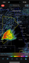
Yeah, that was the cell that originated south of Duncan, OK. Definitely looks to be organizing and getting better structure.Rush springs supercell seems to be close to the boundary. Also structure is improving.
View attachment 42582
https://x.com/NWSFortWorth
@NWSFortWorth
·
3h
A WFO Fort Worth storm survey team has confirmed an EF-1 tornado in and near the City of Gordon in southern Palo Pinto County, in association with last night's storms. Estimated peak winds of 105 mph. Other surveys ongoing. #txwx
@NWSFortWorth
·
3h
A WFO Fort Worth storm survey team has confirmed an EF-1 tornado in and near the City of Gordon in southern Palo Pinto County, in association with last night's storms. Estimated peak winds of 105 mph. Other surveys ongoing. #txwx
TornadoFan
Member
Rush Springs storm is taking more of a northerly track.
AJS
Member
It's possible it may even interact with the dryline. What kinds of effects that could have currently remain to be seen.Rush Springs storm is taking more of a northerly track.


