Muwx
Member
Twins in Nebraska?
Follow along with the video below to see how to install our site as a web app on your home screen.
Note: This feature may not be available in some browsers.
Here’s the wedge tornado from Tx earlier, about to produce another one.
Here’s the wedge tornado from Tx earlier, about to produce another one.
This is why I don't sleep on 5% TOR risk anymore. You never knowNot even in enhanced
Not sure I would call that location a sleeper. It's in a tornado watch zone with 60/30 probs.
Complex series of storm interactions near Ranger, TX. Initial tornadic storm has a bunch of showers moving into the hook/inflow area, plus a stronger storm approaching from the west with its own hook/rotation. Should be interesting to see how the next 20 minutes unfolds with that mess.
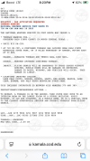
MESOSCALE DISCUSSION 0866
NWS STORM PREDICTION CENTER NORMAN OK
0716 PM CDT SUN MAY 18 2025
AREAS AFFECTED...WESTERN OKLAHOMA...WESTERN AND CENTRAL
KANSAS...SOUTHWEST NEBRASKA
CONCERNING...TORNADO WATCH 286...287...
VALID 190016Z - 190215Z
THE SEVERE WEATHER THREAT FOR TORNADO WATCH 286, 287 CONTINUES.
SUMMARY...THE THREAT FOR TORNADOES, VERY LARGE HAIL AND WIND DAMAGE
WILL CONTINUE ACROSS PARTS OF NORTHWEST OKLAHOMA AND WESTERN KANSAS
AND SOUTHWEST NEBRASKA OVER THE NEXT SEVERAL HOURS. MULTIPLE STRONG
TORNADOES WILL BE POSSIBLE.
DISCUSSION...THE LATEST HI-RESOLUTION RADAR FROM VANCE AIR FORCE
BASE SHOWS A SUPERCELL IN NORTHWEST OKLAHOMA, WITH ADDITIONAL SEVERE
STORMS AND SUPERCELLS LOCATED NORTHWARD INTO WESTERN KANSAS AND
SOUTHWESTERN NEBRASKA. THE SUPERCELL IN NORTHWEST OKLAHOMA IS
LOCATED JUST TO THE NORTH OF A BULLSEYE OF MLCAPE EXCEEDING 5000
J/KG, ACCORDING TO THE RAP. THE RAP ALSO SHOWS A STRENGTHENING 40 TO
50 KNOT LOW-LEVEL JET OVER SOUTHERN KANSAS AND NORTHERN OKLAHOMA.
THE LATEST WSR-88D VWPS AT VANCE AIR FORCE BASE HAS A WIND PROFILE
FAVORABLE FOR INTENSE SUPERCELLS AND TORNADOES, WITH STRONG
DIRECTIONAL SHEAR IN THE LOWEST 2 KILOMETERS AND A LONG LOOPING
HODOGRAPH. RAP FORECAST SOUNDINGS IN NORTHWEST OKLAHOMA THIS EVENING
HAVE 0-6 KM SHEAR NEAR 55 KNOTS, WITH 0-3 KM STORM-RELATIVE HELICITY
IN THE 350 TO 400 M2/S2, WHICH IS IDEA FOR TORNADOES. ALTHOUGH THE
SUPERCELL IN NORTHWEST OKLAHOMA HAS RECENTLY WEAKENED, THE CURRENT
THINKING IS THAT RE-INTENSIFICATION OF THIS STORM WILL OCCUR. ALSO,
IT APPEARS THAT AN INTENSE SUPERCELL MAY ALSO DEVELOP WITH THE STORM
NEAR FORT SUPPLY. AS SUPERCELL RE-CYCLING OCCURS OVER THE NEXT
COUPLE OF HOURS, THE POTENTIAL FOR STRONG TORNADOES IS EXPECTED TO
BE MAINTAINED ACROSS NORTHWEST OKLAHOMA. EF2+ TORNADOES AND VERY
LARGE HAIL WILL BE POSSIBLE.
NORTHWARD INTO WESTERN KANSAS AND SOUTHWEST NEBRASKA, MULTIPLE
INTENSE SUPERCELLS ARE ONGOING. THE STORMS ARE LOCATED ALONG THE
EASTERN EDGE OF A CORRIDOR OF STRONG INSTABILITY, WITH THE RAP
ESTIMATING MLCAPE IN THE 2000 TO 3000 J/KG RANGE. THE LATEST WSR-88D
VWP AT DODGE CITY, KS HAS A LARGE LOOPING HODOGRAPH, WITH 0-6 SHEAR
NEAR 60 KNOTS, AND 0-3 KM STORM-RELATIVE HELICITY NEAR 700 M2/S2. AS
THE LOW-LEVEL JET CONTINUES TO RAMP UP, A POTENTIAL FOR STRONG
TORNADOES WILL BE MAINTAINED, ESPECIALLY IN THE AREA NEAR AND TO THE
SOUTHWEST OF HILLS CITY, KANSAS. VERY LARGE HAIL WILL ALSO BE
POSSIBLE WITH THE CELLS.
..BROYLES.. 05/19/2025

It's why I only watch Max now, him combined with the bot? Makes it just about unwatchable.Alright, I’m with y’all. The y’all bot is officially annoying. I get he’s using it as a mechanism so he doesn’t have to talk continually, but sheesh
I've just been using Max at this point, actual meteorologist who pays more attention, even if it's still lacking sometimes.Alright, I’m with y’all. The y’all bot is officially annoying. I get he’s using it as a mechanism so he doesn’t have to talk continually, but sheesh
Sht @AJS hook..View attachment 42329
Could be the next one to go.
I do like Ryan Hall and what he does (his "Y'all Squad" stuff is great), but yeah, his bot has been verbally roasting random people who comment down the past few weeks... distracts from the actual tornadoes and is unnecesary.Alright, I’m with y’all. The y’all bot is officially annoying. I get he’s using it as a mechanism so he doesn’t have to talk continually, but sheesh