
Lol! no I was aiming for apocalyptic, because that’s what WX Twitter will doI know that the term you meant is "apoplectic" but given how WXTwatter acts these days, "apocalyptic" fits just as well anyways!
Navigation
Install the app
How to install the app on iOS
Follow along with the video below to see how to install our site as a web app on your home screen.
Note: This feature may not be available in some browsers.
More options
-
Welcome to TalkWeather! We see you lurking around TalkWeather! Take the extra step and join us today to view attachments, see less ads and maybe even join the discussion. CLICK TO JOIN TALKWEATHER
You are using an out of date browser. It may not display this or other websites correctly.
You should upgrade or use an alternative browser.
You should upgrade or use an alternative browser.
Severe Weather Threat May 17-19, 2025
- Thread starter Brice W
- Start date
jiharris0220
Member
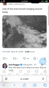
Unfortunately this is not one of those times where cloud cover could b*st a set up.Because I can look at current satellite and see that NC ok and SC KS are still socked in clouds and there they are high clouds further west. I’m not saying it will b*st the set up but it’s something to watch.
Could cover kills sets ups because it denies destabilization in the OWS which can deny convection in the OWS.
Obviously, convection today is solely dryline convection, which is not covered in fog or overcast. Cape values in Oklahoma along the dryline are over 5000j/kg already and tornado parameters are up to 9 in some spots; with helicity values up to 200m2/s2 and the LLJ is already starting to intensify.
My main point is that if today relied on OWS supercells then the cloud cover could’ve been an issue. But because todays tornado risk comes from dryline convection, the cloud cover doesn’t matter at all.
TornadoFan
Member
Already got Van Halen blasting. Lol.
Muwx
Member
If the warm sector stays socked in clouds like it currently is, it will absolutely limit the outcome. It might not keep them from initiating but it will absolutely limit available energy.Unfortunately this is not one of those times where cloud cover could b*st a set up.
Could cover kills sets ups because it denies destabilization in the OWS which can deny convection in the OWS.
Obviously, convection today is solely dryline convection, which is not covered in fog or overcast. Cape values in Oklahoma along the dryline are over 5000j/kg already and tornado parameters are up to 9 in some spots; with helicity values up to 200m2/s2 and the LLJ is already starting to intensify.
My main point is that if today relied on OWS supercells then the cloud cover could’ve been an issue. But because todays tornado risk comes from dryline convection, the cloud cover doesn’t matter at all.

Kds86z
Member
lake.effect
Member
There's still plenty of time for the warm sector to clear out. Main storm initiation is still 6ish hours away.
WAA will be rapid if/when that happens. Too early to say, but it could be a limiting factor. I suspect it will have minimal effect.
WAA will be rapid if/when that happens. Too early to say, but it could be a limiting factor. I suspect it will have minimal effect.
Muwx
Member
Yep. I’m not being a crazy down player here. Clouds are a legit concern.I asked Trey..
That would absolutely lower the ceiling since a lot of the mature convection was in Kansas, with a one or two cells going in Oklahoma. I just don’t see these crazy 4/26/91-like HRRR runs verifying.I asked Trey..
jiharris0220
Member
Cape values in Oklahoma are already exceeding 5000j/kg, I’m not sure where you’re seeing cloud cover limiting potential energy.If the warm sector stays socked in clouds like it currently is, it will absolutely limit the outcome. It might not keep them from initiating but it will absolutely limit available energy.
The inversion layer will prevent OWS convection even without the cloud cover over it.
It’s the dryline that will be initiating all convection today, the only real failure mode is coverage and storms growing upscale too quickly where they initiate.
TornadoFan
Member
AJS
Member
Clouds starting to dissipate in Kansas now?
Kds86z
Member
Muwx
Member
Which could lead to Oklahoma firing way too early before the kinematic support arrives. Then, cloud over is a huge concern in Kansas. This place is an echo chamber at times but people are absolutely talking about this outside of this forumCape values in Oklahoma are already exceeding 5000j/kg, I’m not sure where you’re seeing cloud cover limiting potential energy.
The inversion layer will prevent OWS convection even without the cloud cover over it.
It’s the dryline that will be initiating all convection today, the only real failure mode is coverage and storms growing upscale too quickly where they initiate.
Muwx
Member
He said that 2 hours ago and it’s still there. You all gotta learn how look at twitter time stampsForecaster says in an hour.
Schoeppeya
Member
Supercells are surface based storms so I think acting like storms moving into an area of less available surface energy to feed on would have no impact on their intensity would be unwise. That cloud deck along the ks ok border is thick enough it’s actually dropped surface temps a few degrees so it bears watching. That being said, the HRRR keep initiating storms further south and south of that colder pocket so while it may limit the overall even I don’t know that it prevents a potential high end event. We also have a long ways to go before storms fire.Cape values in Oklahoma are already exceeding 5000j/kg, I’m not sure where you’re seeing cloud cover limiting potential energy.
The inversion layer will prevent OWS convection even without the cloud cover over it.
It’s the dryline that will be initiating all convection today, the only real failure mode is coverage and storms growing upscale too quickly where they initiate.
jiharris0220
Member
No, convection won’t initiate until the bulk of the forcing mechanism arrives, which won’t be until 3pm.Which could lead to Oklahoma firing way too early before the kinematic support arrives. Then, cloud over is a huge concern in Kansas. This place is an echo chamber at times but people are absolutely talking about this outside of this forum
You need more than just high cape values for convective initiation.
Kds86z
Member
He said that 2 hours ago and it’s still there. You all gotta learn how look at twitter time stamps
Fair enough