Schoeppeya
Member
HRRR definitely trending towards convecting the dryline further south. I think at the very least that justifies the moderate getting expanded further south on the next outlook.
10z:

11z:

10z:
11z:
Follow along with the video below to see how to install our site as a web app on your home screen.
Note: This feature may not be available in some browsers.
At least you caught Keota.Not exactly last time, I've chased there a few times since (including 4/26 and 5/21/24) with less spectacular results.
")
Yeah, we saw what one isolated supercell can do last night in this kind of environment.Note the addition of a 10% hatched risk in western Oklahoma on the 1300 update.
Also, the wording used in the discussion makes me think the forecasters would love to have that 5% hatched tornado option to use today for southern Iowa through NE Kansas. Sounds like the possibility of one or two isolated supercells there could be very dangerous were they to fire and sustain.
After the morning convection dies off and moves out, there will be a few hours of tranquility at the surface, the calm before the storm, if you will. However, the atmosphere will be doing all but remaining calm in preparation for round 2. In some scenarios, morning convection can dampen the potential for redevelopment later in the day. In today's scenario, morning convection may actually aid in creating a better environment for round 2. How is that so? The morning storms will allow the strong inversion to remain in place. Maintaining this inversion causes surface winds to respond more to the deepening pressure gradient. Additionally, a roaring low-level jet will have no issue re-energizing the atmosphere after morning storms roll through. Southerly winds will advect warm and moist air into southern Minnesota beneath the elevated mixed layer. This difference in conditions (dry air in the EML and moist air at the surface) creates the instability needed for storms. The HREF is forecasting MUCAPE values of 2000-2500 J/kg, dewpoints in the mid 60s, mean deep layer shear around 50kts, and breakable CIN (-30 J/kg or less) through around 6PM. With this in mind, most of the conditions needed for severe storms will be present, but it`s the initial trigger mechanisms that are needed to actually get storms to initiate. This is where the conditional threat comes in. IF that trigger occurs (breaking any potential cap) ahead of the squall line anticipated to ride the cold front later in the evening, then strong tornadoes are possible with discrete supercells. This potential for strong tornadoes is what is driving the Moderate Risk (4/5). It is entirely possible the trigger never happens and the only convection we see in round 2 is with the passage of the cold front this evening. Tornadoes would still be possible with this scenario, but the storm mode would be linear (QLCS) versus discrete (supercells). This typically translates to brief spin-ups and the the primary threat transitions to damaging wind along the line of storms.
The takeaway from today's severe storm potential is to remain vigilant of the potential for storms to go up quickly. This may mean checking your phone more often or keeping an eye to the sky, but don't let your guard down in this environment.
...
DISCUSSION...PV
Yep, this is exactly what I was hoping wasn't going to happen.
I was hoping there would be enough cloud cover to prevent a good bit of instability, but it seems that there will be just enough so that overmixing won't really happen, and instability isn't inhibited much at all.What you mean?


")
April 26, 2024 comes to mind.Has there ever been a reasonably high end tornado outbreak affecting both the upper Midwest and Oklahoma (or even north Texas) on the same day? If so, when?

Time to stop looking at the CAMS everyone. Real time obs will tell the story. Also, I highly suggest everyone stay off X for today
I’m hoping that chasers win big again, but that these beasts also stay out of populated areas.
Well if you want the best storm structure I recommend eastern Ohio and Western Pennsylvania, but I don't see why storm structure up there wouldn't be pretty good.View attachment 40570
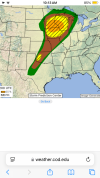
This may be a dumb question, but I'm planning on chasing tomorrow's threat and I don't want to stray too far from my location. Would the highlighted area be worth chasing, or is most of the interesting activity going to be outside of this area?
All I'm really looking for is interesting storm structure, not really any tornadoes specifically.