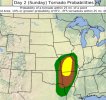
Potential for a robust event appears possible Sunday afternoon/evening.
Follow along with the video below to see how to install our site as a web app on your home screen.
Note: This feature may not be available in some browsers.
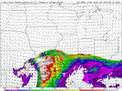
Over 600 m2s2 of SRH. That is pretty scary to say the least.God spare Missouri, for the love of Pete..
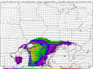
Surprised there's not a hatched tornado risk for this event tommorow. HRRR looks rather impressive with a broken line of supercells
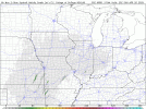
Day 2 was hesitant on some things..
How far west does it look to get started? Most of the action has avoided far western Missouri this year.Volatile 12z CAM suite for tomorrow, including the MPAS runs which are basically a tornado outbreak over MO.
Lots of the semi discrete convection in extreme low level SRH and enough low level buoyancy to use it is a recipe for trouble.
Far enough west that Kansas City and Springfield are of concern.How far west does it look to get started? Most of the action has avoided far western Missouri this year.
Thanks, Andy. Always look forward to your thoughts on these things, especially when I’m in the risk zone.Far enough west that Kansas City and Springfield are of concern.
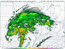
Convection won’t be isolated enough for strong tornadoes per SGF.Kind of wondering why there isn't a hatched tornado risk for tomorrow. Tornadoes are likely going to be significant if they occur given the magnitude of the low level shear.
I think that's nonsense, low level shear is strong enough for significant tornadoes with either supercellular or QLCS modes.Convection won’t be isolated enough for strong tornadoes per SGF.