tornado examiner
Member
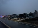
People who rebuilt in monette have had their homes and businesses destroyed for the second time in just over 3 years.
Wtf
Wtf
Follow along with the video below to see how to install our site as a web app on your home screen.
Note: This feature may not be available in some browsers.
uh... it missed the center of monette tough, i think there might of been possibly only 2 home areas that got hit.People who rebuilt in monette have had their homes and businesses destroyed for the second time in just over 3 years.
Wtf

Like I said it hit that row of silo’s further south destroying them, directly north to the monette manor nursing home. And nearly flattened a home across the street.uh... it missed the center of monette tough, i think there might of been possibly only 2 home areas that got hit.
View attachment 38890
No it was essentially the exact same track through monette. Like, on each others damage swath for awhile.So looks like slightly further (by an order of 100 yards or so) from Monette proper than 2021?
Even so, that's even worse than Moore or Tanner-level luck for violent tornado return periods.
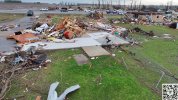
oh i see , any areial view of this area yet?Like I said it hit that row of silo’s further south destroying them, directly north to the monette manor nursing home. And nearly flattened a home across the street.
This has photo proof. I need to find some
Only at night so far.oh i see , any areial view of this area yet?
The problem is they'll probably say the debris is right next to the home, not blown yards away. You conclusively need that these years.Better image of this home in lake city showing clear anchor bolts.

Yep. This is something Trey has noted on his channel a few times. Higher Jet speed can correlate with more violent outbreaks and discrete storm modeDid some reading for fun on the OMEGA project in the SPC. Interesting read, and I believe this was the internal model that helped Broyles decide on a high risk yesterday.
Yeah, not happening. Dug up every damage photo I could find so far and there’s no EF5 candidate damage. Twisted mobile home frames can happen in EF2s, I didn’t see any fully clean sweeps, and there wasn’t any extreme granulation or anything that had “the look” we talk about. The Diaz tornado last month was closer to the criteria than this one.Based on the videos and images I've seen, I believe the Selmer tornado has better chance of getting an EF5 rating.
Multiple well-built homes swept away with no debris in the immediate area, but the other construction-based DIs are even more extreme than Lake City - granulated debris, steel frames (likely of mobile homes) twisted and bent like pretzels. We can't know the quality of the slabbed homes just from the images, but these indicators appear to be extreme and could push it into the EF5 category. Just my two cents.
To dumb things down by a lot, it makes good sense from a basic, physical/dynamic level - yesterday's jet was moving fast and hard, providing upper-level force and momentum, intensifying low-level kinematics and ultimately giving storms more opportunity and real estate to kick it into high gear, hence why you got lots of strong tornadoes over a large area for a protracted period of time. More air moving more fasterer high up equals more air moving more fasterer down on the ground.Yep. This is something Trey has noted on his channel a few times. Higher Jet speed can correlate with more violent outbreaks and discrete storm mode


View attachment 38894
fixed version of my tornado path survey.