CheeselandSkies
Member
Bingo. Also in relation to the Skew T
The Skew-T *is* the display of the thermodynamic profile on a sounding.
Follow along with the video below to see how to install our site as a web app on your home screen.
Note: This feature may not be available in some browsers.
Bingo. Also in relation to the Skew T


they were not the main stuff any wayWell those showers were short lived. Only the one by Watonga is left.
Cap is still pretty stout. Not go time yet. Temps are being somewhat held in check by high cloud cover and moist air advection has really slowed down in the last couple hours.Well those showers were short lived. Only the one by Watonga is left.
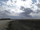
On his stream, Reed Timmer described the current towers as "they go up, they come back down".U can see the dryline west of KFDR, those cumulus bubbles are ahead of the dryline. I don’t expect those to be the ones. Give it another 30-60 minutes.
Which is exactly why the SPC, rightfully so, kept this enhanced. High ceiling if storms go though.Cap is still pretty stout. Not go time yet. Temps are being somewhat held in check by high cloud cover and moist air advection has really slowed down in the last couple hours.
Yeah, I get it. I just don't think their discussion did a very good job of portraying what the ceiling actually could be, but I digress. Lets see what happens.Which is exactly why the SPC, rightfully so, kept this enhanced. High ceiling if storms go though.
U can see the dryline west of KFDR, those cumulus bubbles are ahead of the dryline. I don’t expect those to be the ones. Give it another 30-60 minutes.

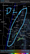
Capping isn't too substantial where the dryline is right now but the T/Td spreads are quite significant. Still a fair amount of time until we have any storms with tornadic potential.Current situation. Interestingly enough, it seems the area the dryline is about to move into has negligible CIN and seems to be uncapped judging by the Skew T overlay.
View attachment 38241
View attachment 38242
Tornado probs on that watch are 50/30.Tornado Watch just issued.
View attachment 38243
Going off of what Trey said, before sundown would probably be the optimal time for storms to go. So we have around an hour to an hour and a half of that left.Capping isn't too substantial where the dryline is right now but the T/Td spreads are quite significant. Still a fair amount of time until we have any storms with tornadic potential.
Dang. Conditional alright lolTornado probs on that watch are 50/30.
Ehhh, they have longer than that. Its not dark in western OK at 6:30.Going off of what Trey said, before sundown would probably be the optimal time for storms to go. So we have around an hour to an hour and a half of that left.