OhOkayThen
Member
Is that the biggest D5 30% ever? Geez
Follow along with the video below to see how to install our site as a web app on your home screen.
Note: This feature may not be available in some browsers.


Nice work. Looks like 3-4 rounds! Tennessee is 40 percent on the tornado probabilities. Flooding will be a major concern I would think here too!Very clear that there will be no rest for the weary here. Also seems like it's possible the first system stalls on its southern side, making way for a series of ejecting troughs to bring their own severe threats, one after the other. Obvious danger there is the moisture won't be swept out of the South like it usually would with frontal passage, so it'll basically prime the whole area for these subsequent systems. Could be a very messy, active and dangerous start to April.
View attachment 37631View attachment 37633View attachment 37634View attachment 37635
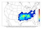
Major outbreak on the 12z GFS from the Midwest all the way south to the Lower MS/Valley and TN Valley.
GFS has finally come around to the scenario that most of the rest of guidance is in agreement with, and the results are... that.I commented on your BlueSky post a bit ago, GFS has bounced around quite a bit from run to run. Guessing Euro along with ensembles have been more consistent?
May I ask what is BlueSky?I commented on your BlueSky post a bit ago, GFS has bounced around quite a bit from run to run. Guessing Euro along with ensembles have been more consistent?
I think we should all do a talkweather storm chase in Monroe County at this point lol.
I wish there was a site that compiled posts from Twitter and BlueSky so I don't have to use either website because I hate them both lolA social media platform.
Just to play devil's advocate here, there are a few things on that GFS run that would give me pause from full-on sounding the alarm for Wednesday just yet.
Namely...there are subtle height rises (0.2 dam/hr over the previous 12 hours) across the region with the most dangerous-looking parameter space (southwest Indiana southward across TN/KY to northern Mississippi). Generally for a tornado outbreak I'd want to see falling heights across the region of interest. In this case it seems the stronger height falls just barely clip even the northern extent of the risk area (northern Illinois), glancing off to the northwest within the cool sector.
Secondly, the surface low is filling with time (980mb at 15Z Wednesday to 986mb at 00Z Thursday). Generally I'd like to see it deepening into the timeframe of interest, backing the surface winds and intensifying the LLJ. That's one of the things I look for to give me high confidence in a big outbreak, we saw it with 3/31/23 and IIRC 4/26/24.

Trust me. I can remember lotView attachment 37641
While I do agree with you generally, this type of more subtle height change with time + a weak cap tends to favor widespread discrete cells. Also, some of the larger events in history had a filling surface low through the afternoon, it is not always needed to have a deepening low.