
- Thread starter
- #121
Navigation
Install the app
How to install the app on iOS
Follow along with the video below to see how to install our site as a web app on your home screen.
Note: This feature may not be available in some browsers.
More options
-
Welcome to TalkWeather! We see you lurking around TalkWeather! Take the extra step and join us today to view attachments, see less ads and maybe even join the discussion. CLICK TO JOIN TALKWEATHER
You are using an out of date browser. It may not display this or other websites correctly.
You should upgrade or use an alternative browser.
You should upgrade or use an alternative browser.
Severe WX Severe threat 3/30-3/31
- Thread starter Bulkshear
- Start date
OhOkayThen
Member
"Supercells" talk on D6 is not ideal
CheeselandSkies
Member
06Z GFS shoved things considerably further south compared to the prior run, which would put it out of reach for me for a work night chase. Long way to go with this one.
- Thread starter
- #124
Bulkshear
Member

Just check the 12z EURO from yesterday. And you'll get why they say supercells on there lol"Supercells" talk on D6 is not ideal
AJS
Member
That’s pretty strong wording for a day 6.Well that’s not the wording you want to hear on a day 6,
AJS
Member
Yeah, i’m honestly not surprised they’ve mentioned supercells this far out.Just check the 12z EURO from yesterday. And you'll get why they say supercells on there lol
UpperLevelLOL
Member
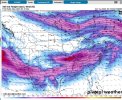
Good grief, this system may bring supercells to *western WA and OR* as it comes onshore, insane weather for March in the PNW
Wow! I had to do a double take on those dews.Expansive warm sector to say the least and both the GFS and Euro are showing it. Euro is definitely more zonal.
AJS
Member
I’m predicting 400+ pages for this thread lmao.
Cips really favors the mid south for this event.
- Thread starter
- #132
Bulkshear
Member
Yeah, I mean I may not be making another thread for a while if that happens… Ha ha haI’m predicting 400+ pages for this thread lmao.
- Thread starter
- #133
Bulkshear
Member
Do you mind posting it so everyone can see what you’re looking at?Cips really favors the mid south for this event.
A major player will be the secondary low. My eyes are on that and the evolution over the next few days.Do you mind posting it so everyone can see what you’re looking at?


Todd
Member
Below in "quotes" from the NWS St. Louis, MO in their early Tuesday morning AFD.
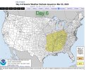
"Meanwhile, a potentially stronger shortwave and developing surface low make their way downstream late Saturday from the Plains. I say 'potentially' because there are vast differences evident in a cluster analysis of ensemble guidance and deterministic models regarding the speed and amplitude of the wave. Even in the scenarios depicting stronger synoptic forcing and ascent, instability remains in question. The CAPE/shear joint probabilities referenced above for Saturday make no improvements for the wave on Sunday, if anything they decrease. Along with the limited energy, the overall trough structure is not very organized. While the stronger deep-layer shear, 40-50 kts among available guidance, is somewhat concerning and would result in a few strong to severe thunderstorm given sufficient instability, this system bears almost no similarities to our last tangible severe weather threat earlier this month. While the SPC has a convective outlooks across the region for Sunday (6 days out), it is worth noting that the lead time of identifying potential severe weather events is in no way correlated to their strength or areal extent. While there is plenty of conditionality and mitigating factors surrounding the severe weather threat both days, they will be closely monitored."
Look nobody wants an outbreak of severe weather, especially tornadoes. People's property gets damaged/destroyed or people suffer injuries/die.
UpperLevelLOL
Member
So the last system had the shear but questions about moisture return, this system has the opposite problem
CheeselandSkies
Member
06Z GFS shoved things considerably further south compared to the prior run, which would put it out of reach for me for a work night chase. Long way to go with this one.
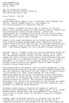
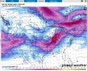
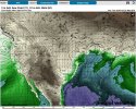
Posting images at the request of @AJS
00Z:

06Z:

Todd
Member
I see where SPC yanked the Saturday (3/29) outlook - yellow shaded area.
Yeah, capping/subsidence will most likely keep a lid on things that day per their outlook.I see where SPC yanked the Saturday (3/29) outlook - yellow shaded area.
tennessee storm chaser
Member
- Messages
- 1,863
- Reaction score
- 4,242
- Location
- jackson tennessee
- Special Affiliations
- SKYWARN® Volunteer
Will that have an effect on sundays threat is key question , what’s your thoughts …. No convection. Now for Saturday much , does that escalate the threat for Sunday ?Yeah, capping/subsidence will most likely keep a lid on things that day per their outlook.