
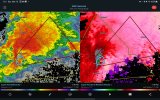
No CC drop but that is some interesting rotation. Good catchLooks like an unwarned CC drop north of Houston, MS
Navigation
Install the app
How to install the app on iOS
Follow along with the video below to see how to install our site as a web app on your home screen.
Note: This feature may not be available in some browsers.
More options
-
Welcome to TalkWeather! We see you lurking around TalkWeather! Take the extra step and join us today to view attachments, see less ads and maybe even join the discussion. CLICK TO JOIN TALKWEATHER
You are using an out of date browser. It may not display this or other websites correctly.
You should upgrade or use an alternative browser.
You should upgrade or use an alternative browser.
Severe WX Severe Weather Threat 3/14-3/16
- Thread starter Bulkshear
- Start date
slenker
Member
It sort of looks like the mode is getting less messy with each passing scan, and things are getting more organized quite quickly.
Evan
Member
I don't think it is controversial to say the latest CAMs made things appear a little less clear.
It is also true that the CAMs sometimes struggle in the immediate proximity of an event before figuring things back out as more data comes in.
Likewise, it makes a lot of sense to focus more on radar, observations, and observed soundings since we're into realtime forecasting now. It was a lot easier to picture a high-end ceiling when the CAMs were consistently showing numerous unmolested discrete supercells in the OWS.
I am already at 79 degrees, and I wasn't forecasted to reach that temperature, and certainly not this soon. Dewpoints seem to be running a few degrees higher than projected for 17z in a number of areas.
Nonetheless, we shouldn't discount that the CAMs are showing a messier storm mode. In particular, the northern movement of storms that several others have pointed out is something to watch closely as that usually impacts the ability for discrete storms to stay discrete with adequate spacing. If we see discrete storms start to move in more traditional ways and maintain better spacing that will also be very telling.
Ultimately, I don't think some of the potential failure modes mentioned should just be rejected automatically -- but, neither should we be thinking that things have downtrended and discrete long-track supercells with significant tornadoes are off the table. It is way too early to buy into a concrete conclusion right now.
TornadoFan
Member
Kentwood storm on the ground.

It took 8 minutes, I was wrong.Greensburg LA storm is really tightening up. Wouldn't be surprised to see a tornado in the next 10-15 minutes.
US_Highway15
Member
TOG north of Kentwood
MikeP
Member
Well it's getting really warm out now. I'm up to 77...I think BMX’s launch will show CAPE already good and in place with a chance to increase further. Upper level support is probably still a little west
jiharris0220
Member
First/second? tornado of the day.

Chris3024
Member
Houston, MS cell really tightened up on velocity
Kentwood storm on the ground.


stallions3peat
Member
What i thought. I heard someone say Spann said that this morning in a video,but i haven't found evidence of that and knew that didn't sound right.No that only makes things worse. More daytime heating through alabama
Houston MS storm could use a tornado warning. 
Already a debris ball I think on it.While not a huge town, this visible CC drop is likely from Kentwood, unfortunately.
View attachment 36067
TornadoFan
Member
They just issued one.Houston MS storm could use a tornado warning. View attachment 36070
UpperLevelLOL
Member
Another 95/95 PDS Watch