Smokedevil
Member
We've got ( I'm guessing here ) about 30 to 35 mph winds here out of the south
(in Monroe county ms )
(in Monroe county ms )
Follow along with the video below to see how to install our site as a web app on your home screen.
Note: This feature may not be available in some browsers.
Ok, I understand now. Thank you. When local tv meteorologists talk about morning rains inhibiting severe chances later on, it confuses me when I see that it can actually make severe threats worse later on.The smithville Mississippi EF5 from April 27 2011 was formed when the supercell that spawned it moved over an outflow boundary left over from a morning line of storms, that lowered the supercell’s base and dramatically increased its inflow. The boundary basically super charged an already EF5 capable storm and lead to the most violent tornado of all time.
That’s the best way I can explain it.
Long story short, outflow boundaries are bad.
I didn’t know that b-word was replaced. Whoops…I weep for those desperate for a cold front Forecasted Convective Amplification Deficiency when that is still nearly stationary this morning and the sun is out already.
Yikes stay safe today.Sun is out in northeast Jefferson county/Southwest Blount AL. Still some very light clouds that are getting burned through. It's about to be very sunny and muggy with this early morning rain evaporating
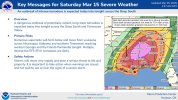
Is it possible that the MDT is extended to cover more of metro ATL?Everything appears on track and I hope everyone stays safe today. Meso and microscale processes will determine how bad it is, but I haven’t found many flies in the ointment this morning to preclude a significant tornado outbreak. For the Georgia people, don’t let your guard down tonight. The tornado and damaging wind threat, especially across North Georgia, is as high as we’ve seen it in a long time.
I’ll actually be surprised if we see that. Especially with the weird linear quirkiness the CAMs are latching onto.If they spc is confident in increased discrete supercell coverage I could still see a 45% tornado risk being added.
Certainly, though I would venture to guess SPC will want to see how convection starts evolving early this afternoon before doing that.Is it possible that the MDT is extended to cover more of metro ATL?
Alright. Definitely got that feeling last night watching those semi-discrete cells plow right through the metroCertainly, though I would venture to guess SPC will want to see how convection starts evolving early this afternoon before doing that.


perhaps he meant in this part of the world. it definitely underperformed back in louisiana and in the jackson, memphis, birmingham, and huntsville markets.…how on earth did yesterday underperform?! And today is the high end of the high end. Trends continue to look historic.