Area Forecast Discussion
National Weather Service Birmingham AL
438 AM CDT Sun Mar 18 2018
.SHORT TERM...
Today and Tonight.
.LONG TERM...
Monday through Saturday.
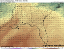
Confidence that the area will see significant severe
thunderstorms continues to increase for Monday, as models are
coming into better agreement on the synoptic pattern. As usual,
there are some mesoscale details that will determine the exact
timing and type of threat. Models are coming into better agreement
with the timing and placement of a compact upper low that will
eject out of the western CONUS trough into northeast New Mexico
this afternoon. It will deamplify slightly as it moves eastward to
the TN/KY border region as it approaches confluent flow
associated with the eastern Canadian trough, but still remain a
potent system with strong height falls and a neutral tilt. A
strong WSW mid and upper level jet max (~90kt at 250 mb, ~70 kts
at 500 mb, ~65 kts at 700mb) will be located to its south, which
will move over Central Alabama. A ~35-40kt southwesterly LLJ at
850mb will accompany a 998mb surface low moving across Tennessee.
This surface low will be close to steady-state in strength during
the afternoon, before effectively splitting into two pieces as it
encounters the southern Appalachians Monday night. A trailing
pre-frontal trough/dry line feature will move into West Alabama
from Mississippi Monday afternoon.
Starting off Monday morning, not expecting to see a whole lot of
activity on the radar due to dry air and capping aloft associated
with an elevated mixed layer and weak shortwave ridging aloft.
Showers and storms associated with Sunday night`s shortwave will
likely be mainly north and east of the forecast area. But with
low-level isentropic lift there could be some light showers, and
perhaps some isolated leftover thunderstorms from Sunday night.
There will probably be some low stratus as well. One possible
wrench in the forecast is a secondary LLJ in the NAM and some of
the global models that these models show causing an increase in
moisture and isentropic lift across southeast Alabama and the
Florida panhandle during the late morning with associated
precipitation. This could affect destabilization in the afternoon,
or if accompanied by thunderstorms could result in an isolated
severe threat developing earlier than expected in the far
southeast counties. However, the CAMs are much further east with
this activity, closer to the Florida Big Bend and South Georgia.
These may have a better handle on the situation if they are
handling Sunday night`s preceding convection better than the
global models. Also, the models that show this feature all still
indicate very strong instability developing by Monday afternoon
across the entire area, so it may not matter much.
Most of the day on Monday may be a nice warm sunny spring day, but
folks should not let their guard down. This daytime heating will
allow CAPE values of 2000 to 3000 J/kg to develop due to
temperatures in the upper 70s to low 80s. The 00Z NAM did show an
unlikely situation where low stratus clouds never mix out all and
surface temperatures remaining much cooler, preventing convective
initiation. But this seemed extremely unlikely given the strong
southwesterly flow and dry air aloft. The 6Z NAM has already
trended back in line with strong daytime heating, but is slower
with the storms than the guidance consensus as is its typical bias.
The WRF-ARW, NSSL WRF, and WRF-NMM were in good agreement in
explosive thunderstorm development along the pre-frontal trough/
dry line as upper- level forcing arrives, between about 4PM and
7PM roughly along/northwest of the I-59 corridor. These storms
will probably initiate right over Central Alabama rather than
moving in from Mississippi. The convective mode will be a broken
line of semi- discrete supercells, due to westerly 55-60kt 0-6 km
bulk shear vectors orthogonal to the initiating boundary. Dry air
aloft/capping will likely inhibit storms from developing ahead of
this line, except perhaps in the far northeast counties, so
confidence in timing out this line is increasing. The environment
will be very favorable for large to very large hail to develop due
to the rotating updrafts and fat CAPE profiles more typical of
the Plains than the Southeast, with significant hail >2" diameter
appearing likely with some of the storms. Damaging winds will also
occur with the hail-enhanced downdrafts due to high DCAPE.
Concerning the tornado potential, the 850mb-925mb flow will be a
bit veered to the southwest and not extremely strong. This veered
flow will probably mix down to the surface; the NAM is more backed
but does not seem to be mixing the boundary layer properly as
mentioned related to the spurious looking low stratus mentioned
above. The surface low will also not be deepening, so isallobaric
flow will not be a factor. So near-surface streamwise vorticity
does not appear to be enhanced, with the critical angles between
the 0-0.5km shear vector and 0-0.5km storm-relative flow being
mainly well below the optimal 90 degree angle. This could be a
limiting factor for the strong (EF2+) tornado potential. Still,
the presence of strong rotating updrafts in a high CAPE
environment with around 200m2/s2 0-1km SRH can compensate somewhat
for the less than favorable wind directions. Therefore, think
there is a threat for a couple to maybe a few tornadoes, even if
they may be EF0/EF1 especially the further north you go closer to
the surface low, and especially right around/just after sunset
when the nocturnal LLJ begins to strengthen. One potential area
of concern for strong tornadoes, however, is the far northeast
counties where flow could remain a bit more backed, near a
lingering wedge front over north Georgia. Confidence remains too
low to mention the potential for a strong/significant tornado in
the HWO/graphics, but we will continue to monitor closely as we
get closer. Either way, these will be dangerous storms that
everyone needs to pay attention to. .