Day 2 Convective Outlook
NWS Storm Prediction Center Norman OK
1249 AM CDT Sat Mar 17 2018
Valid 181200Z - 191200Z
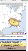
...THERE IS A SLIGHT RISK OF SEVERE THUNDERSTORMS ACROSS PARTS OF
AL...MS...AND THE ARKLATEX REGION...
...THERE IS A SLIGHT RISK OF SEVERE THUNDERSTORMS FROM SOUTHWEST KS
INTO NORTHWEST OK...
...THERE IS A MARGINAL RISK OF SEVERE THUNDERSTORMS FROM THE CENTRAL
PLAINS TO THE CENTRAL GULF COAST...
...SUMMARY...
Scattered severe storms are possible Sunday from the Arklatex area
southeastward into southern Alabama. A few severe storms are also
expected across southwest into central Kansas and across northwest
Oklahoma during the evening.
...Synopsis...
A potent shortwave trough will move across the Four Corners states
during the day, with the nose of a 100 kt midlevel jet overspreading
the central and southern High Plains during the evening with rapid
cooling aloft. Meanwhile, low pressure will deepen over eastern CO
into western KS. Strong lift along a cold front will interact with
marginal instability to support rapid storm development during the
evening.
To the south, a leading low-amplitude wave will move across
northeast TX during the day, with shortwave ridging over the lower
MS Valley. A quasi-stationary front will extend from the Arklatex
eastward across MS and AL, with mid to upper 60s F dewpoints to the
south. This general zone will support scattered storm development
through the period, beneath favorably strong flow aloft to support a
few strong to severe storms.
...Arklatex into southern Alabama...
Thunderstorms are expected to be ongoing across the Arklatex Sunday
morning near or north of the front, supported by weak low-level warm
advection. Marginal hail is possible with the early activity. Later
in the day, these storms will move across southern AR and into MS
along the boundary, and may evolve into severe storms as instability
increases. In addition, wind profiles will strengthen aloft as the
disturbance moves out of TX. Damaging winds may be the main threat
if the storms organize into an MCS. Otherwise, wind profiles do
favor supercells, although low-level SRH will not be particularly
strong. Still, a tornado or two will be possible.
Elsewhere, a moist and unstable air mass, along with favorable
deep-layer shear, will remain across northeast TX into LA. However,
forecast soundings indicate some capping concerns, and lift in the
wake of the departing wave will be minimal. In addition, mass fields
will be adjusting toward the northwest as the central Plains low
deepens. Conditionally, large hail is possible should an isolated
storm form.
...Southwest/Central KS into northwest OK...
Thunderstorms are expected by early to mid afternoon over
eastern/northeast OK, AR and southwest MO due to warm advection.
Most of these storms should be north of the warm front, and thus
elevated. Marginal hail will be possible with this activity.
Farther west, strong heating will occur across the High Plains,
where surface convergence will rapidly increase as the low deepens.
Cooling aloft will overspread this warm air mass, resulting in steep
lapse rates. Wind profiles will support supercells. However,
instability will be weak, as dewpoints only rise into the 40s F.
Still, strong lift will result in an arcing line of storms by around
00Z, with hail and wind possible. A tornado cannot be ruled out
given the vorticity-rich environment, steep lapse rates, and ample
low-level shear, mainly over southwest KS into far northwest OK.