• Welcome to TalkWeather!
    We see you lurking around TalkWeather! Take the extra step and join us today to view attachments, see less ads and maybe even join the discussion.
    CLICK TO JOIN TALKWEATHER

Severe WX Severe Weather Threat 3/14-3/16

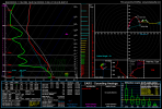
The latest NAM (18z) has this sort of sounding 12hours before the main event on Saturday. (Sounding taken in the same general area around central Mississippi).

The high end outbreaks generally have volatile kinematics several hours before the climactic phase. Obviously even this is still 4days, (84hours) out so a lot can still change, for better…..or worse.
1741726666565.png
 
I can honestly see Friday over night going moderate , while
Strides has chance of high risk ceiling if things line up
The only chance I see Friday going moderate will be because of the straight line wind risk.

Shear will be fairly directional along with the relatively weak instability and strong forcing, I’m worried for a respectable qlcs system with multiple bow echos generating winds between 40-70mph.
 
Talk weather is the only social media I have ;)

It’s time to start this thread at this point. Too many models on board with a significant event. First picture is showing the low barometric pressure of this thing. Crazy….
Well - Spann is starting to “ratchet up” ($1 to unclejuju) his wording regarding this weekend. Never good to see him talk about a significant severe weather situation 3-4 days out).

 
The latest NAM (18z) has this sort of sounding 12hours before the main event on Saturday. (Sounding taken in the same general area around central Mississippi).

The high end outbreaks generally have volatile kinematics several hours before the climactic phase. Obviously even this is still 4days, (84hours) out so a lot can still change, for better…..or worse.
View attachment 35049
A little noobie with this, how do you change the date to look ahead? I can only look at the past 2 days.
 
Let me preface by saying I don't have the credentials to make this comparison, but I'll try to add some perspective. The 04/27/2011 outbreak was precipitated by a 995 mb low over Kentucky, had 500 SRH, 2500 J/kg SB and MUCape, 1000 J/kg DCAPE, and 86 kts of mid level SHR. I was rolling my eyes hard when people were comparing this system to 2011 a few days ago, and there's still not a valid comparison, but the way this is trending might have me hopping towards the alarmist train a bit. Still need a few more model runs to fully hop on. However, this system doesn't need to fully match 2011 to produce incredibly violent tornadoes, because 2011 produced some of the strongest tornadoes we've ever seen. Anxiously awaiting the more refined models tomorrow.

EDIT: 4/27/2011 was also prefaced by 3000-4000 J/kg CAPE the night before the storm, and even though it was cleared out by the QLCS that moved through, i'm sure it was still a factor. I doubt we're deep enough into spring to reach those levels, so maybe that'll dampen the impact in some abstract way.

1741726434995.png
 
Last edited:

Let me preface by saying I don't have the credentials to make this comparison, but I'll try to add some perspective. The 04/27/2011 outbreak was precipitated by a 995 mb low over Kentucky, had 500 SRH, 2500 J/kg SB and MUCape, 1000 J/kg DCAPE, and 86 kts of mid level SHR. I was rolling my eyes hard when people were comparing this system to 2011 a few days ago, and there's still not a valid comparison, but the way this is trending might have me hopping towards the alarmist train a bit. Still need a few more model runs to fully hop on. However, this system doesn't need to fully match 2011 to produce incredibly violent tornadoes, because 2011 produced some of the strongest tornadoes we've ever seen. Anxiously awaiting the more refined models tomorrow.

EDIT: 4/27/2011 was also prefaced by 3000-4000 J/kg CAPE the night before the storm, and even though it was cleared out by the QLCS that moved through, i'm sure it was still a factor. I doubt we're deep enough into spring to reach those levels, so maybe that'll dampen the impact in some abstract way.

View attachment 35048
I think you have a potential shot at reaching 3000j of sbcape in central Alabama. Again it depends on the low pressure imo. Will see though. 2000-2500j of sbcape is still relatively high cape, and I think that's what is shown currently on the GFS For around peak heating in central Alabama if I'm not mistaken
 
I got a question, so if I spot a tornado or funnel cloud am I able to call the NWS of BMX. And tell them I see one? I'll have great view of any northern Jefferson county storm.
Yeah, in the good ol days the standard recommendation was to call (toll free!). As a kid I memorized Peachtree City's number. Not sure what BMX's is but if you don't have social media you can call them, give your precise geographical location and credentials and give a concise description of what you're reporting. That's how it was done in FFC's jurisdiction back then, dunno if it's changed or not.
 
Back
Top