• Welcome to TalkWeather!
    We see you lurking around TalkWeather! Take the extra step and join us today to view attachments, see less ads and maybe even join the discussion.
    CLICK TO JOIN TALKWEATHER

Severe Weather Threat - May 6, 2024

Modelling had fairly consistently depicted delayed but aggressive development across SW OK a few hours after the current storms; I'm guessing that's what they are banking on.
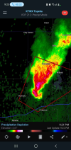
In fact you can see it on visible satellite best. Stuff sitting in E TX and W OK will probably be developing over the next several hours.
1715044549163.png
 
You’re right. They’re some of the the best in the world for a reason - guess I just got a little too into “radar watching”
Radar-watching is also really good at making time seem to pass quickly even though it's actually going by pretty slowly. Have done that many times myself.
 
The 01z mesoanalysis has a large area that actually surpasses the scale for the Violent Tornado Parameter...it looks like 20 is the highest it goes. According to the paper that created the VTP, the 90th percentile in their sampling was 10.1 for confirmed violent tornadoes. So having a large part of central OK being maxed out (somewhere) above 20 is just astounding and mind-boggling.

The big question is what will take advantage of this....


1715044501702.png


1715044611159.png
 
From OUN: Timing Update: Current line of storms continues to progress eastward through area 1. Anticipate this line to stay mainly north of I-40. That being said, we're seeing indications that a second line may develop late tonight around the I-44 corridor, affecting central and possibly southern Oklahoma. We're also watching some attempts at convection along the dryline in southwest Oklahoma, but chances of that amounting to anything appear low at this time.
 
Don’t exactly know why the current segment of storms are doing hell all, but thank goodness so.

Although I’m getting worried about the second round as the moment they form the environment will be more than primed, and this is the segment that’s headed into the OK city metro.
I certainly hope it stays quiet, but I'm definitely not trusting it to.
 
Cell behind that Greenfield storm developing rotation.
1715045224188.png
 
Back
Top