Austin Dawg
Member
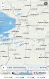
22 degrees with a small chance of sleet or ice with no accumulation expected here in northern Austin. We are the western edge of this system.
Y'all be carefull!
Y'all be carefull!
Follow along with the video below to see how to install our site as a web app on your home screen.
Note: This feature may not be available in some browsers.
Yes I know us vets here have been through the wringer on the snow battles in these parts. I was hoping your snow nose could kick in and beat the warm nose and who knows…it might still but the bright Sunny weather today is not a good lead in as I expect to get max hearing here then have the clouds cap off the cooling tonight. That’s a small portion of the overall battle but we are going to need all the positives here we can get.Yep yep - definitely a warm nose. It just needs to lose the fight a little further south please. 66 in Baton Rouge, 18 in Memphis. Combat indeed.
View attachment 23374
Yes I know us vets here have been through the wringer on the snow battles in these parts. I was hoping your snow nose could kick in and beat the warm nose and who knows…it might still but the bright Sunny weather today is not a good lead in as I expect to get max hearing here then have the clouds cap off the cooling tonight. That’s a small portion of the overall battle but we are going to need all the positives here we can get.
Yes there is still a chance for some surprises but I guess being a lifer of the I-20 area, I’m a bit cynical on what we will wind up with out of this.
I will say that is a much deeper well of arctic air than we usually get to work with, and it's been producing snow all day in OK and AR so the snow cover area is moving southeast. With that said, it's also a warmer GOM. So it's like both combatants on the field have more to work with than we're used to seeing. It's going to be quite a system. I am hoping for all snow or all rain at this point, but I know the line has to be somewhere. It's going to be slippery on Tuesday BHM north I'm thinking, regardless. I'm going to optimistically go with Morris, AL being the dividing line between ZR and snow. Keeping hope.
Yeah there are definitely a lot of real time obs we are going to have to factor in to get a clear read on this one but I could absolutely see your Morris cut off point happening as well. I’d take a “south of Bessemer/McCalla” cut off myself…being selfish but yes we do have some different than normal players on the field too here.I will say that is a much deeper well of arctic air than we usually get to work with, and it's been producing snow all day in OK and AR so the snow cover area is moving southeast. With that said, it's also a warmer GOM. So it's like both combatants on the field have more to work with than we're used to seeing. It's going to be quite a system. I am hoping for all snow or all rain at this point, but I know the line has to be somewhere. It's going to be slippery on Tuesday BHM north I'm thinking, regardless. I'm going to optimistically go with Morris, AL being the dividing line between ZR and snow. Keeping hope.
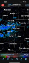
And is that even reaching the ground would be my question?Looks like show showers are showing up on radar in north Mississippi. Game on!
And is that even reaching the ground would be my question?
MEG (Memphis) did state in previous discussions snow starting during the afternoon, but I don't think they expected this much.Was precip expected this early?
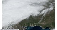
12Z HRRR caught the orientation of it pretty well. This is 2pm. Definitely more moisture than it expected though. 18Z run the moisture is ahead of by about 3 hours.Was precip expected this early?