• Welcome to TalkWeather!
    We see you lurking around TalkWeather! Take the extra step and join us today to view attachments, see less ads and maybe even join the discussion.
    CLICK TO JOIN TALKWEATHER

Severe Weather Threat - January 8th-9th, 2024

The cell east of Carolina Beach, NC, reminds me in a way of Joplin 2011:

View attachment 23195
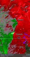
That's likely had a significant tornadic waterspout with it for a while. Truly would be the "storm of the day" if it was producing over land.

With that said, if it holds together it WILL impact Morehead City, or areas immediately to their west. Lots of homes there, so this could get bad.
 
Reed needs to get in touch with the right people and get a Dominator Boat or Sub going
Hmmm... maybe he could buy this one
1
 
With a combined 25 tornado reports between 12Z periods + at least half a dozen tornadoes in the Mobile area seen on radar, we ended up with a pretty substantial event. Was also a prolific wind producer (thunderstorm and non-thunderstorm), and the supercell cluster near PCB was remarkable in a bad way.
1704853715511.png1704853727022.png
1704853923500.png1704853987508.png
 
Man films PCB tornado (language warning):


That's...not nearly as visually intimidating as I thought it would be. Looks like a spin-up honestly, but given the wide, intense damage path, I was expecting a big wedge or multi-vortex. Goes to show you can't always estimate how strong a tornado is just by it's appearance.
 
Still no ratings out, but Marianna, FL is looking like either high-end EF2 or minimal EF3. I know the house in the first video looks like solid EF3, but it's obvious the home's attached garage failed catastrophically, and took most of the house with it. The huge intact section of roof in the front yard, and the unmoved, undamaged car in the garage also make me go "hmmm". Those are all things that are going to be factored in.

 
Back
Top