
-
Welcome to TalkWeather! We see you lurking around TalkWeather! Take the extra step and join us today to view attachments, see less ads and maybe even join the discussion. CLICK TO JOIN TALKWEATHER -
 April 2024 Weather Video of the Month Post your nominations now!
You are using an out of date browser. It may not display this or other websites correctly.
You should upgrade or use an alternative browser.
You should upgrade or use an alternative browser.
Winter Weather 2021-2022 Discussion
- Thread starter Mike S
- Start date

Well it looks like we do have a sharp arctic boundary with a ripple of upper air energy running along it. This kind of setup can provide more ice than snow....especially in the south. The weekend's forecast is going to be tricky as the cold air will likely be shallow and plenty of moisture nearby
But looking at the 0z gfs run, the high isn't in a favorable position to keep the cold air flowing in...
But looking at the 0z gfs run, the high isn't in a favorable position to keep the cold air flowing in...
Last edited:
Jacob
Member
Models still have wildly different solutions for Friday's system. GFS has a few flurries on the NC coastline, and the system out to sea. Euro digs the piece of energy a lot further west, and results in a major snowstorm for parts of Georgia, Tennessee, SC, NC and the entire east coast. Euro's solution is also a major ice storm for parts of GA and the Carolinas.
Just a slight bit of difference here, and only 108 hours out
UKMET, NAM, and Canadian are trending towards the solution from the Euro yesterday. Need the trough to dig another couple hundred miles west to make it a big deal for Alabama, but this could be a major winter weather producer for GA/TN/SC/NC and up the east coast.
Weatherphreak
Member
I’m really hoping the GFS verifies so I can hit up the north Georgia mountains for some hiking.
Weatherphreak
Member
Just read that Huntsville is mentioned light accumulating snow for Friday in its discussion. Sounds like a repeat of last weekend.
Jacob
Member
I’m really hoping the GFS verifies so I can hit up the north Georgia mountains for some hiking.
Looking a little more like you'll be OK for that this afternoon. Today's GFS and UKMET/Euro sorta met in the middle, with some snow/ice problems for the Carolinas, and maybe parts of eastern GA.

Weatherphreak
Member
Almost posted this earlier. SE getting multiple storms this winter. I’m about snowed outGFS for next NEXT Saturday, 2/5/22. I know - it's WAYYY early. Something to watch (w/ low confidence atm).
View attachment 12048
Looks like winter weather is back in South Central Texas but nothing like last year's apocalyspe.
FXUS64 KEWX 310011
AFDEWX
Area Forecast Discussion
National Weather Service Austin/San Antonio TX
611 PM CST Sun Jan 30 2022
LONG TERM (Tuesday through Sunday)...
Daytime Tuesday begins with most areas seeing a light and variable or
light northeast breeze and some wrap-around moisture possibly
holding the clouds and perhaps some patchy fog in place. With clouds
to decrease by midday and a zonal flow pattern aloft over TX, we
should get a good day of warming with highs in the 70s almost area-
wide.
An amplifying pattern upstream brings a quick return of overnight
cloudiness over the area Tuesday night, and then a dramatic weather
change by late Wednesday when an arctic front arrives. Wednesday
afternoon should see a partial fropa into the Hill Country to leave
us with a good sized Max T gradient from north to south. We trended
warmer with these maxes as the 12Z deterministic runs deepened the
upstream trough to signal a stronger and slower moving upper low.
This will also translate to the overnight temperatures to reverse
slightly, the cooler trend that was noted for the 00Z forecast
cycle. Another shifting trend is that QPF output continues to grow
for the first 18 hours behind the front, and that could further slow
down the rate of cooling at least before the very cold dew point
temperatures arrive after daybreak Thursday.
Thus while we a showing slightly increased confidence in the freezing
line advancing south to set the scenario for a winter mix Thursday
morning, predominant precipitation types of rain and freezing rain
versus sleet or potentially some light snow at the end of the precip
event hasn`t changed much. Overall amounts of QPF are trending
wetter, but this could also wind up compressing the time window for
rain to change over to a mix before the conveyor belt of moderate to
heavy precip rates pull to the east early Thursday. Thus we`ll
continue to leave our ice accumulation amount forecast minimized
until there becomes a more consistent timing of the change-over.
The 12Z model cycle continues to so sharp drying late Thursday and no
significant trailing dynamics to move over our part of TX for any
potential snowfall of significance. However, some silent 10 percents
are offered in the PoPs to suggest a low potential going into
Thursday night. Friday night continues to be a good bet for a
widespread hard freeze. The Friday high temps are forecast to creep
above Freezing before another hard freeze settles in Friday night. A
weak disturbance in the westerlies could set up a brief wintry mix
opportunity Saturday, but there aren`t enough model groupings to
warrant any mention of weather chances outside of some light rain
showers through Sunday.
billdurham
Member
Glenn Burns from WSBTV ATL shared this article.. Interesting read.
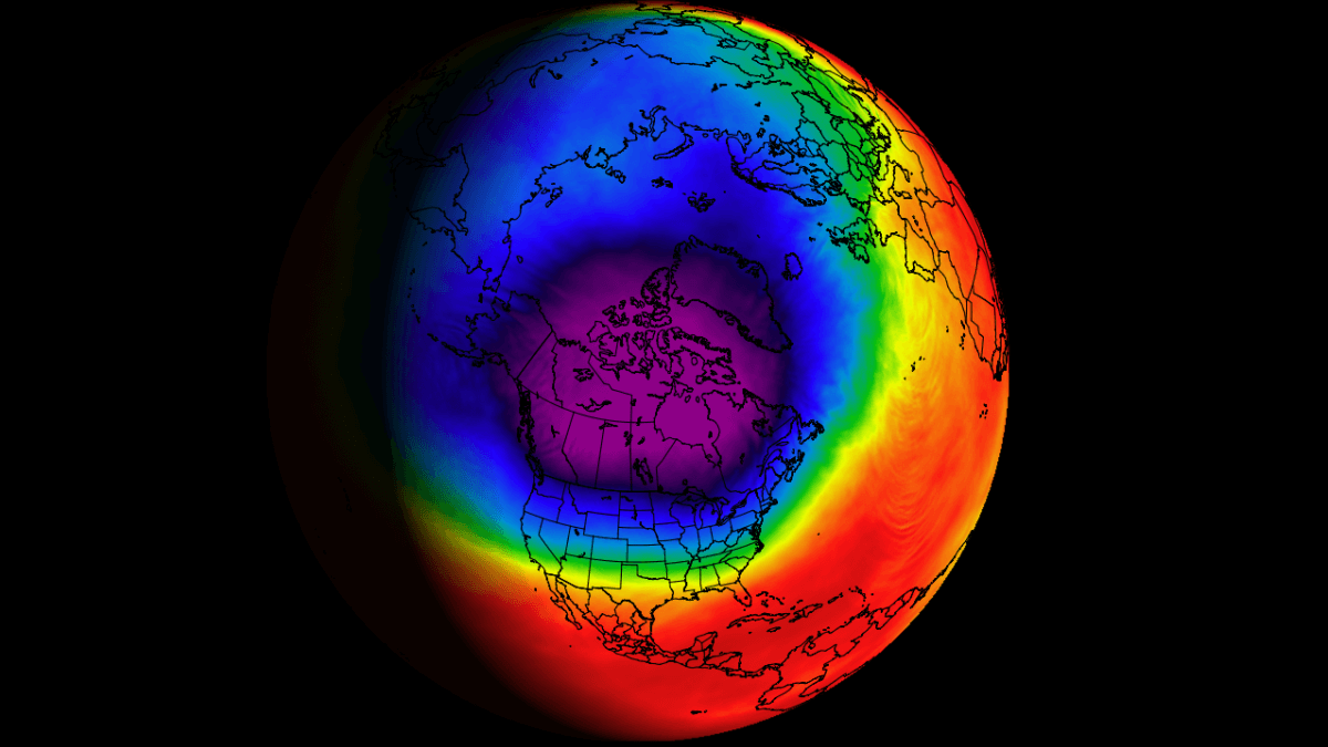
 www.severe-weather.eu
The Polar Vortex starts to behave strangely, cooling down to record levels and going into overdrive, shaping the weather as we head for Winter finale
The weather in the United States will be influenced by the polar Vortex now powering up to unusually strong levels, as we go into late Winter
www.severe-weather.eu
Thanks for sharing. He breaks this down where even I can begin to comprehend what the Polar Vortex is and how it affects us.Glenn Burns from WSBTV ATL shared this article.. Interesting read.
The Polar Vortex starts to behave strangely, cooling down to record levels and going into overdrive, shaping the weather as we head for Winter finale
The weather in the United States will be influenced by the polar Vortex now powering up to unusually strong levels, as we go into late Winter
Weatherphreak
Member
WAFF mentioned possible winter weather Sunday in North Alabama. Still far out.
JPWX
Member
Definitely gonna be interesting. Other than light accumulations on grassy surfaces, I wouldn't expect much. However, expect the unexpected as Spann says. Also it's worth pointing out that this potential winter weather event corresponds to around the dates as the 93 Storm Of The Century.