• Welcome to TalkWeather!
    We see you lurking around TalkWeather! Take the extra step and join us today to view attachments, see less ads and maybe even join the discussion.
    CLICK TO JOIN TALKWEATHER
  • April 2024 Weather Video of the Month
    Post your nominations now!
Messages
2,256
Reaction score
2,856
Location
Missouri
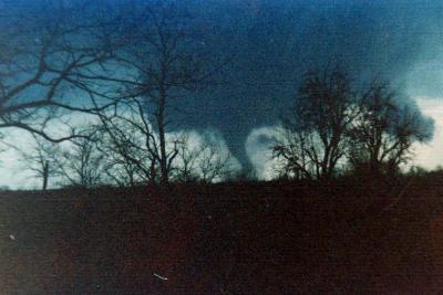
Other pictures of 4/3/74:

Jasper, Alabama F4:-5a1d74fd46ce30f2.JPG-8701f7a2fa2a3154.JPG-277913e225ec1fcf.JPG-98940830b359175e.JPG-c6c60cc81536e5b8.JPG-e5752ba768c6fc86.JPGJasper1974.PNG


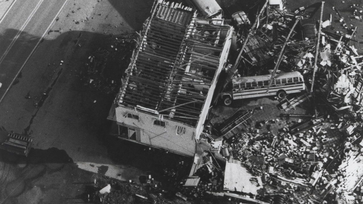
This pic from Brandenburg I've never seen before:
SchoolBus.jpg


NOAA link to article on 50th anniversary of event:


Link to the Indiana section of the outbreak:


locomusic01

Member
Messages
1,376
Reaction score
3,833
Location
Pennsylvania
So, this is random and maybe only of interest to me, but I thought it was a pretty amazing coincidence. Part of my New Richmond article (I know, I know - it's coming along) deals with the fact that the New Richmond tornado family very closely followed the Chicago, St. Paul, Minneapolis & Omaha Railway (aka the Omaha Road) for most of its lifespan. This obviously took it through several communities, including New Richmond itself, since towns tended to form along railroads at that time and vice versa.

What I'd somehow never realized until this morning is that the same is true to some extent of all three days of activity. On June 11, the day before New Richmond, the undocumented tornado that preceded the Homer-Salix F4 formed north of Emerson, NE and crossed the Omaha Road just south of Hubbard, doing a fair bit of damage to the few properties it encountered there. Incidentally, the overnight F2 tornado near Swea City, IA also occurred just a few miles south of one of the railroad's branches running south from Blue Earth, MN.

Anyway, the day after New Richmond, June 13, is of course when a very intense F4+ destroyed most of Herman, NE. As it happens, Herman was literally built around a railroad — the Omaha Road. It was located on the southern/westernmost section of the railway that ran down to Omaha itself. Even with railroads being everywhere at that time, the odds of all three days of tornadic activity taking place along the same railway seem rather remote. And not just that, but both of the hardest-hit towns (New Richmond and Herman) being literally built on the same line some 300+ miles apart? Pretty wild.

In fact, going by my map of the outbreak sequence, if you started on a branch line of the Omaha Road in Barron, WI (where the final death from the New Richmond tornado family occurred) and rode the line ~360 miles west to Herman, you'd pass within five miles of 10 separate tornado tracks which killed at least 136 people in total. And if you started a little further east in Cameron, WI (the final town impacted by the New Richmond family) you'd pass straight through seven different communities that were directly struck by tornadoes (Cameron, Barron, Pineville, Stanton, New Richmond & Boardman in WI; Herman in NE). In my personal opinion, all of those places likely suffered F5 damage except Cameron and Barron, where it was probably around F1 and F2-F3, respectively. (EDIT: Actually, slight correction - I'd estimate Stanton was more like F3 as well, maybe borderline F4).

You could potentially add Burkhardt, WI (F4-F5) to the list as well depending on how you define a "direct" hit, but it missed what I'd consider the main part of the settlement by like 500 yards or so.

(Sorry for the excessively long post btw, way too much coffee already this morning lol)
 
Last edited:

joshoctober16

Member
Messages
156
Reaction score
120
Location
Canada New brunswick
I'm just curious as to his reasoning for backpedaling from EF5 to EF4 on Twitter. But yeah, no ratings have been changed for any tornado (so far). Now the volume that will go from 1680-1973 I wonder if he might change up some things.
there was one tornado listed as a F5 he would of put in the book but we don't know what one....

its to note tanner 2: should of been rated F4 but some error made it F5
on the greensburg 2007 outbreak there were 3 giant EF3 that happend from the same supercell one should of been rated EF4 but the same error made it to EF3 and no one corrected it. its 2 examples of they got rated somthing when surveyed but when the final results came out there F/EF rating was up or down by 1 by some mistake....
 
Messages
57
Reaction score
16
Location
Byron, CA
The most notable event in the South Western United States is a strong F1 tornado that destroyed a mobile home park on Jun 23 1974, near Tuscon, AZ causing 40 injuries and 1 fatality.
 
Last edited:

HAwkmoon

Member
Messages
23
Reaction score
4
Location
Europe
Thanks! That's for Bridge Creek. I haven't checked my Tri-State folder but I'm sure it's probably like half that.


Besides Tri-State, I'd really like to revisit my Palm Sunday article someday. I've collected tons of photos since I wrote it, but I also don't feel like I did nearly a good enough job covering some of the lesser-known tornadoes especially. Somehow it's still a hugely underrated outbreak IMO.


I'd totally forgotten about it tbh. I'll have to make a note to reach out to them again. The whole May 1896 outbreak sequence has been on my list to cover forever, but it's a bit intimidating because it's so huge and there doesn't seem to be much available photo-wise (besides St. Louis obviously).
Thanks for the response! Means a lot. Can't wait for the New Richmond article. 250 for tristate and bridge creek is equally impressive, obviously there is no way you could include all of them in an article but damn I would love to have a folder with that many photos xd.
Is there a link for this site?
For bridge Creek I was wondering, was the DOW measurement whilst the tornado was over Willow Creek Estates or the Southern Hills Subdivision? I remember reading there were several 300+ mph measurements as well. Have you got an image of the worst scouring from Bridge creek too, cause apparently it was over a foot deep?
Lastly, in several of your photos you say you found them at the ELCA disaster response site. Do you have a link to this site or is it available to the public?
 

Timhsv

Member
Messages
457
Reaction score
805
Location
Huntsville, AL.
Special Affiliations
  1. SKYWARN® Volunteer
Smithfield F5, April 4 1977
1712277458603.png

This tornado is named after the area which received the greatest damage: Smithfield Drive and Smithfield Lane. Per the Storm Data Summary: The twister developed about 4 miles NW of downtown Birmingham. It moved to the northeast at 60 mph and lifted east of Tarrant. 167 homes were destroyed, 48 had major damage. 22 people were killed, 130 injured. Image from the NWS Birmingham.
 

csx1985

Member
Messages
20
Reaction score
20
Location
Mobile, Alabama
what i mean is...

1:well built home completely swept clean with debris all turned into little parts and thrown furuther away.
2:has to have properly space bolts with properly fitted sized and tightened washers and nuts.
3:removeal of large percentage of baseplates form the foundation
4:anchor bolts were bent or snap off by the tornado
5:ground scouring or complete grass scouring.
6:trees within 100 yards all debarked and or flatten and some thrown away, all small shrubs/bushes are without leafs and debarked.

and within every image is see no complete grass scouring and trees standing beside the foundations looking pretty ok.

the first 4 rules are by tim marshall.
rule 5 is from some presentation by nws for EF4 vs EF5 damage.
rule 6 is for villonia,mayfeild.

when you look at it that way all the damage points of phil campbell seem less EF5 then villonia and bremen who were rated EF4, there is also a weird sitatuion with rainsville with trees being fine beside the main EF5 damage point.

i do have to say the last image is the most EF5 ish ive seen out of the bunch, and seems to be pretty much there tough the grass isnt completely scoured.
I still don’t understand why the “trees within 100 yards all debarked and or flattened and some thrown away” DI do not take into account a multivortex structure. Is that considered upwind or downwind related to the vicinity of the affected area?

Also, the extent of the wind rowed steel structure of the Hackleburg jeans factory is something that I doubt has ever been seen before.
 

joshoctober16

Member
Messages
156
Reaction score
120
Location
Canada New brunswick
I still don’t understand why the “trees within 100 yards all debarked and or flattened and some thrown away” DI do not take into account a multivortex structure. Is that considered upwind or downwind related to the vicinity of the affected area?

Also, the extent of the wind rowed steel structure of the Hackleburg jeans factory is something that I doubt has ever been seen before.
for bremen the trees that were standing all were missed by the core, its just nws trying to find evrey excause to not rate a tornado EF5 it seems , theres even a home swept clean but only rated as a weak EF2, there reasoning is that debris hit the home. unknown (2).png
 

buckeye05

Member
Messages
3,354
Reaction score
5,215
Location
Colorado
There was more to the sub-EF5 rating in Bremen, KY than lackluster tree damage. The house construction there was iffy and I broke it down in detail in an older post. The “main” EF5 candidate home was weird. It was a CMU foundation perimeter, with a poured concrete slab ON TOP of the CMU, and had gravel poured into the void in between. I don’t know if I’d feel comfortable going with EF5 based on a house built like that, honestly.

While I do think Mayfield/Bremen had 200+ MPH winds at times, it’s not the eggregious, no-brainer, slam dunk shoulda-been-rated EF5 that Vilonia was. The contextual damage in Vilonia was even worse than what was photographed in Bremen, and Vilonia slabbed multiple classic, well-built, “poured slab with anchor bolts”-type homes. I don’t know if Mayfield even slabbed a single house of that type. Best construction was in Cambridge Shores, but contextuals there were more EF4ish.

I’ve said this before, but if we had the construction quality from Cambridge Shores and the contextual evidence from Bremen overlap in the same area, we’d have a no-brainer EF5 imo (whether the survey results would have reflected that is anybody’s guess though).
 

csx1985

Member
Messages
20
Reaction score
20
Location
Mobile, Alabama
It's definitely an outbuilding, not a slab home. NWS Huntsville overdid it when it comes to assigning EF5 DI's during the Hackleburg survey, and many of their assigned EF5 damage points are rather questionable to say the least. That's really all there is to it.

Now there were spots with genuine EF5 damage including those duplexes in Hackleburg, a duplex in Phil Campbell, the well built home in Oak Grove and a restaurant in Mount Hope, among others.
Could it possibly be that NWS Huntsville just gave some EF5 DI’s as a “benefit of doubt” type situation? I think it’s pretty obvious that this tornado maintained it’s EF5 intensity between Hackleburg and Phil Campbell.

Some good discussion and points being made here regarding DI’s of Hackleburg and Bremen.
 

HAwkmoon

Member
Messages
23
Reaction score
4
Location
Europe
Well it’s finally done, here is the May 4, 2007 Greensburg tornado track map and the ‘Big 4’ track map as well. Greensburg also has a contour map which was created by meticulously (and I mean VERY meticulously) examining dozens upon dozens of aerial and ground photos/videos coupled with the aerial imagery, Tim Marshall’s survey, and eyewitness reports. Since this is the first EF5 I’ve mapped, I decided to do something a bit different. There are now two contours for the EF5 areas, one is light pink and is where ‘plausible EF5’ damage occurred or where EF5 winds may have occurred, then the dark purple, where the ‘offically rated EF5’ areas are, OR, where EF5 winds almost certainly occurred and where extreme damage occurred that’s synonymous with an EF5 tornado. I’ve got to say I was surprised how many intense areas of damage there was in Greensburg, especially in northern parts of the city where some of the most impressive damage I’ve seen occurred. A large Mennonite Church and multiple homes were swept completely away, trees were 100% debarked, wind-rowing occurred, and ground scouring was also evident. Anyways, here’s the map for you guys to check out (it’s a little messier than I expected). You can also click on the purple contour areas in the northern side of the city for a damage description.


This isn't loading for me, could you make it a KML or something? Would love to see this.
 
Messages
538
Reaction score
477
Location
Northern Europe
Another overlooked-but-significant event was the outbreak (sequence?) of 24–5 April 1880. The event generated significant tornadoes from the easternmost edge of the Great Plains eastward to the southern Appalachians. The first day began with an F2 tornado that destroyed or otherwise damaged up to 12 homes in Joplin MO. Activity later spread into eastern MO/western IL, including at least four intense tornadoes. A large F4 tornado killed one person and injured 10 others as it destroyed 25 rural homes and numerous barns, including a spacious farmhouse that was leveled, near Medora IL. Another F4 near Carlinville IL wrecked buildings on more than 24 farmsteads and swept away numerous farmhouses. An F5 tornado obliterated part of West Prairie IL, carrying bodies up to 1/2 mi and annihilating well-constructed farmhouses. An F3 tornado that probably developed in eastern MO damaged or destroyed about a dozen homes in northern Adams County IL as well.

The second day was no less notable. An F2 tornado hit Grassy Cove TN, leveling part of a forest and wrecking several structures. Another F2 tornado, potentially stronger and long-tracked, hit Paint Rock AL, wrecking at least five homes and likely injuring numerous people. Most intriguingly, an extremely violent F4 tornado hit Macon MS, obliterating 20 or more homes on the northwestern side of town. Reportedly, machinery was tossed 100 yd and loaded (!) railcars hurled the same distance. Parts of homes were found up to 15 mi distant and many well-constructed homes were annihilated, leading to the deaths of entire families in the worst-hit areas. Information is limited, but this tornado definitely sounds like an F5 candidate. The Grassy Cove and Paint Rock tornadoes may well have been much stronger and longer-lived than listed in Significant Tornadoes, and the Carlinville IL tornado from the preceding day may have been capable of F5 damage as well.
 
Messages
538
Reaction score
477
Location
Northern Europe
Based on information that has been shared in this thread or elsewhere, which of the SPC’s “official” F5s, from the pre-EF era, would likely merit an EF5 rating today, if the EF scale were properly applied? Here is my preliminary list:

Definite or Probable EF5s, 1950–2007
1953 Beecher MI
1955 Blackwell OK*, Udall KS
1956 Hudsonville MI
1957 Ruskin Heights MO*, Fargo ND
1958 Colfax WI
1966 Jackson (Candlestick Park) MS, Topeka KS
1968 Tracy MN
1970 Lubbock TX*
1971 Waverly LA/Delta City MS*
1974 Xenia OH, Brandenburg KY, Tanner AL #1/2, Guin AL
1976 Brownwood TX, Jordan IA
1977 Birmingham (Smithfield) AL
1984 Barneveld WI
1985 Wheatland PA
1990 Hesston/Goessel KS, Plainfield IL
1991 Andover KS
1992 Chandler MN
1996 Oakfield WI
1997 Jarrell TX
1998 Oak Grove AL, Lawrence County TN
1999 Bridge Creek OK

*Low-end EF5

Not enough information is available re: Waco, Ft. Rice, Adair, Sunfield, Prague, Wichita Falls, Bradshaw, Gregory, Charles City, Oelwein, Valley Mills, Depauw, Sayler Park, and Spiro. In my view their EF5 candidacy cannot be ascertained with any certainty until more information is accessed. In addition to these, several “unofficial” F5s would likely qualify, a number of which are listed by Thomas P. Grazulis (i.e., at least a few of the Palm Sunday 1965 events). Vicksburg, Belmond, Gallipolis, and Broken Bow were rather obviously not EF5s, being F4-worthy at most.
 
Messages
1,124
Reaction score
1,437
Location
jackson tennessee
Special Affiliations
  1. SKYWARN® Volunteer
Based on information that has been shared in this thread or elsewhere, which of the SPC’s “official” F5s, from the pre-EF era, would likely merit an EF5 rating today, if the EF scale were properly applied? Here is my preliminary list:

Definite or Probable EF5s, 1950–2007
1953 Beecher MI
1955 Blackwell OK*, Udall KS
1956 Hudsonville MI
1957 Ruskin Heights MO*, Fargo ND
1958 Colfax WI
1966 Jackson (Candlestick Park) MS, Topeka KS
1968 Tracy MN
1970 Lubbock TX*
1971 Waverly LA/Delta City MS*
1974 Xenia OH, Brandenburg KY, Tanner AL #1/2, Guin AL
1976 Brownwood TX, Jordan IA
1977 Birmingham (Smithfield) AL
1984 Barneveld WI
1985 Wheatland PA
1990 Hesston/Goessel KS, Plainfield IL
1991 Andover KS
1992 Chandler MN
1996 Oakfield WI
1997 Jarrell TX
1998 Oak Grove AL, Lawrence County TN
1999 Bridge Creek OK

*Low-end EF5

Not enough information is available re: Waco, Ft. Rice, Adair, Sunfield, Prague, Wichita Falls, Bradshaw, Gregory, Charles City, Oelwein, Valley Mills, Depauw, Sayler Park, and Spiro. In my view their EF5 candidacy cannot be ascertained with any certainty until more information is accessed. In addition to these, several “unofficial” F5s would likely qualify, a number of which are listed by Thomas P. Grazulis (i.e., at least a few of the Palm Sunday 1965 events). Vicksburg, Belmond, Gallipolis, and Broken Bow were rather obviously not EF5s, being F4-worthy at most.
About the Lawrenceburg Tennessee 98? Think
 
Logo 468x120
Top