• Welcome to TalkWeather!
    We see you lurking around TalkWeather! Take the extra step and join us today to view attachments, see less ads and maybe even join the discussion.
    CLICK TO JOIN TALKWEATHER
  • April 2024 Weather Video of the Month
    Post your nominations now!

Western_KS_Wx

Member
Messages
214
Reaction score
602
Location
Garden City KS
Off topic, but I still wonder why the Rozel KS tornado in May 2013 is still designated as an EF4, despite the rating being based entirely on DOW wind speed measurements of 165-185mph. I find it odd how the tornado kept its EF4 rating, when both Bennington and of course El Reno later that month were downgraded to EF3 when measured wind speeds were well into the EF5 range. Rozel also produced low-end EF3 damage at best to only one farmstead, pictured below. CB985557-7F7C-4355-B219-E0696FE51177.jpeg

A bit of a random post, but I just think it’s odd how the same reasons El Reno and Bennington got downgraded didn’t apply to Rozel for whatever reason, not to mention it’s probably the LEAST deserving candidate for a violent rating out of the 3.
 

TH2002

Member
Sustaining Member
Messages
3,490
Reaction score
5,618
Location
California, United States
Special Affiliations
  1. SKYWARN® Volunteer
Off topic, but I still wonder why the Rozel KS tornado in May 2013 is still designated as an EF4, despite the rating being based entirely on DOW wind speed measurements of 165-185mph. I find it odd how the tornado kept its EF4 rating, when both Bennington and of course El Reno later that month were downgraded to EF3 when measured wind speeds were well into the EF5 range. Rozel also produced low-end EF3 damage at best to only one farmstead, pictured below. View attachment 22784

A bit of a random post, but I just think it’s odd how the same reasons El Reno and Bennington got downgraded didn’t apply to Rozel for whatever reason, not to mention it’s probably the LEAST deserving candidate for a violent rating out of the 3.
To be fair, Rozel apparently threw a large propane tank a quarter mile and scoured a gravel road, which IMO does at least give credence to it having had violent winds. Haven't been able to find photos of this damage however, and I don't think there was any genuine EF4 structural damage with that tornado.
 

Western_KS_Wx

Member
Messages
214
Reaction score
602
Location
Garden City KS
To be fair, Rozel apparently threw a large propane tank a quarter mile and scoured a gravel road, which IMO does at least give credence to it having had violent winds. Haven't been able to find photos of this damage however, and I don't think there was any genuine EF4 structural damage with that tornado.
Yeah you can make somewhat of an argument that supports EF4 intensity, albeit in my opinion gravel scouring isn’t necessarily a strong case for violent winds. I think that Rozel maintaining an EF4 rating solely from DOW measurements while the other two tornadoes were downgraded is just a major flaw in consistency with the EF scale.

Getting off topic again (tend to do that often) the tank being lofted by Rozel randomly reminded me of these photos I have from an EF3 tornado that passed near Jetmore KS on March 28, 2007. For being such a significant outbreak it is massively overshadowed, and seems to have been swept under the rug due to other events that same year (Greensburg) and years afterwards.

Anyways, here’s some photos from the Jetmore-Beeler KS EF3, starting with the tank that reminded me I even had these photos in the first place.
36D43E3B-8F1C-4A70-B5E1-8D2CA2961E14.jpeg
E7111DFA-D60A-4282-BE55-A7F1230F75DA.jpeg
The tornado managed to loft a 10,000 pound tank for a full mile before it crashed into a road reportedly leaving a giant impact mark before coming to rest.

08242AC0-B239-4A30-8CFC-57B7BF7E0F51.jpeg
(Edit) This same farm was also hit by another EF3 tornado from the Dodge City supercell on May 24, 2016.
4D705672-E540-43AD-83EE-D01EC4CB2F00.jpeg
0AC80648-D6F0-4BE0-95B6-A92648629DBA.jpeg
2742496F-72F8-4FDF-9299-6450CC82E33D.jpeg72BBE554-F114-4DDE-8CFE-0B707B6E598F.jpegAB998806-C82A-484F-97DE-CEDBA5E87561.jpegAB2754D2-FCCC-4593-A0E9-B3F9113F8FEA.jpeg
53F71D54-05E6-4D60-8975-A11F531F289E.jpeg


This tornado in my opinion was probably violent at some point, just stayed out in essentially the middle of no where. However it still managed to strip and debark trees and shrubs, kill a herd of 90 cattle (of which 20 were never found), loft large debris from a shed and a wedding book registry 30+ miles away, and scour farm fields.
 
Last edited:

pohnpei

Member
Messages
967
Reaction score
1,977
Location
shanghai
Off topic, but I still wonder why the Rozel KS tornado in May 2013 is still designated as an EF4, despite the rating being based entirely on DOW wind speed measurements of 165-185mph. I find it odd how the tornado kept its EF4 rating, when both Bennington and of course El Reno later that month were downgraded to EF3 when measured wind speeds were well into the EF5 range. Rozel also produced low-end EF3 damage at best to only one farmstead, pictured below. View attachment 22784

A bit of a random post, but I just think it’s odd how the same reasons El Reno and Bennington got downgraded didn’t apply to Rozel for whatever reason, not to mention it’s probably the LEAST deserving candidate for a violent rating out of the 3.
Maybe because they just forget this tornado....
 
Messages
2,924
Reaction score
4,855
Location
Madison, WI
Messages
2,260
Reaction score
2,862
Location
Missouri
Scrolling online and found this photo of forest damage from Tionesta in a PDF article about forest management:

Tionesta.png

I'm not sure if this was taken post-cleanup but I don't think it was. I'd love to see a before picture of this; reminds me of the aftermath of Mount St. Helens eruption.

Source is below:
 

Attachments

  • 3-2_BasicForestMngmnt2.pdf
    3.2 MB · Views: 0
Messages
2,260
Reaction score
2,862
Location
Missouri
So TornadoTalk is doing a multi-part series on the Frankfort, KY tornado from 4/3/74, it's still in progress at the moment. They've managed to dredge up an incredible amount of photos and info I've never heard about this thing before, and they don't have access to any of Fujita's damage surveys on it, keep that in mind. I eagerly await what they dig up on many of the other tornadoes from this outbreak, especially Guin. This year will be the 50th anniversary of this event pretty crazy.

 
Last edited:
Messages
2,260
Reaction score
2,862
Location
Missouri
His family apparently still has the tape, I just haven't been able to get my hands on it yet. And that's one of a few photos I didn't include in my article because I got conflicting info on them and wasn't able to 100% confirm where or when they were taken. I originally got it from a librarian in Albion and she said it was taken down near the OH/PA border, which is a few miles SW of Jumbo Woods. Another local guy said it was taken just outside of Cranesville. And then I've also seen it labeled as being the long-track F2 that struck near Beaver Center on June 22. The latter may actually be most likely since it closely resembles some of the other photos from that tornado.
Was this the tornado that went from multivortex wedge to narrow stovepipe all of a sudden? It's path right before Albion and afterwards seems to be a bit more narrow and scattershot.
 

TH2002

Member
Sustaining Member
Messages
3,490
Reaction score
5,618
Location
California, United States
Special Affiliations
  1. SKYWARN® Volunteer
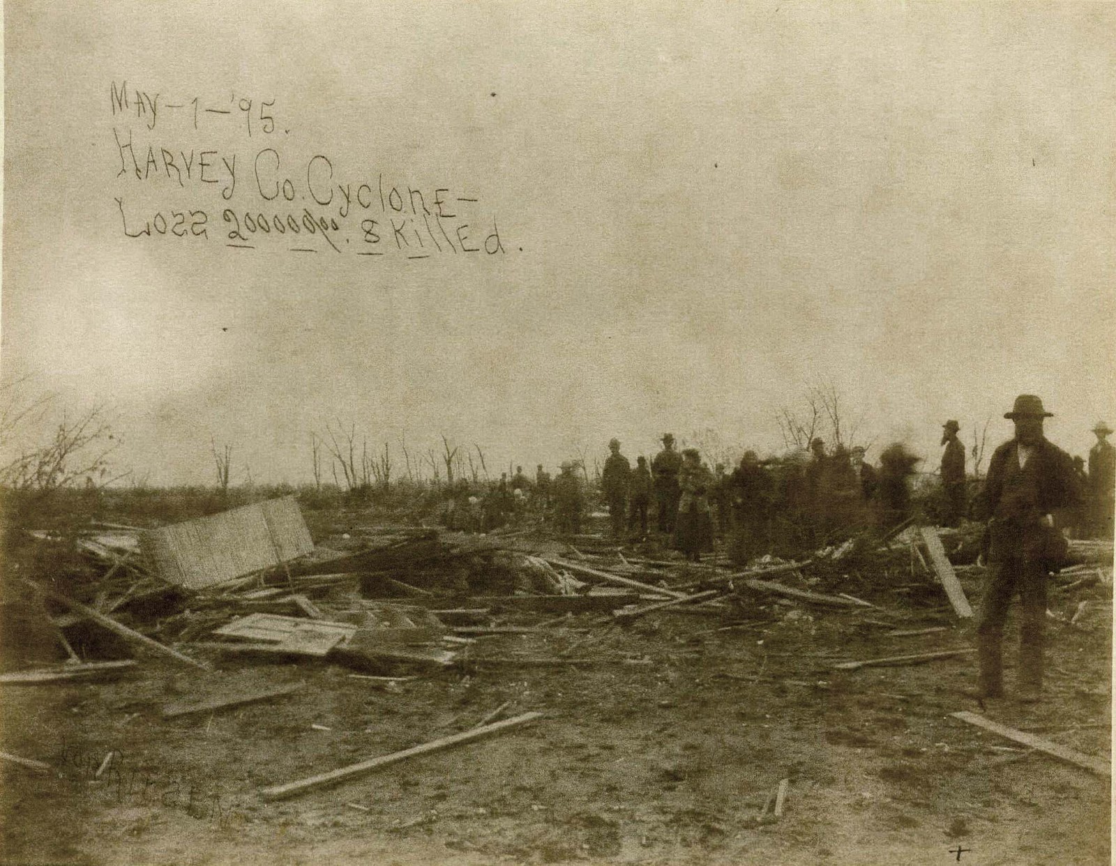
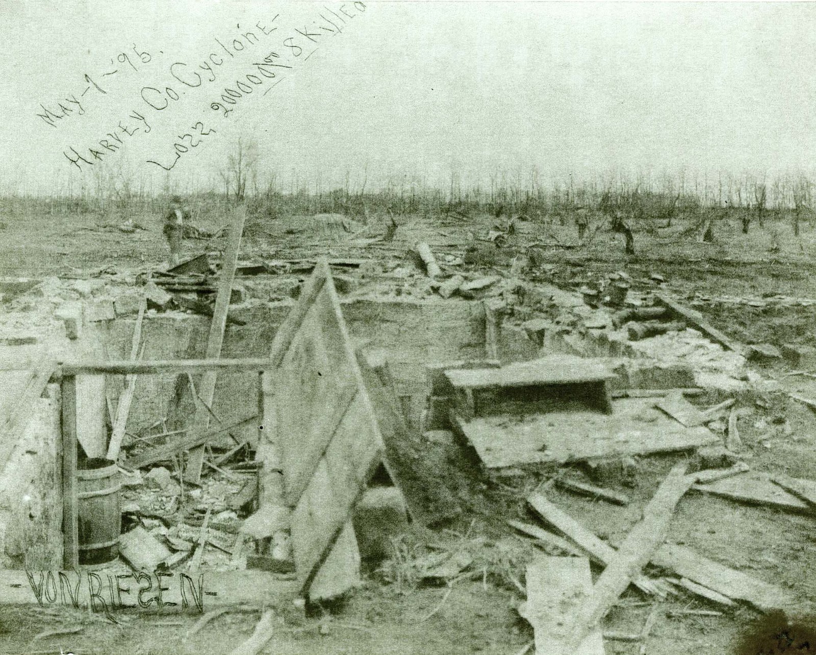
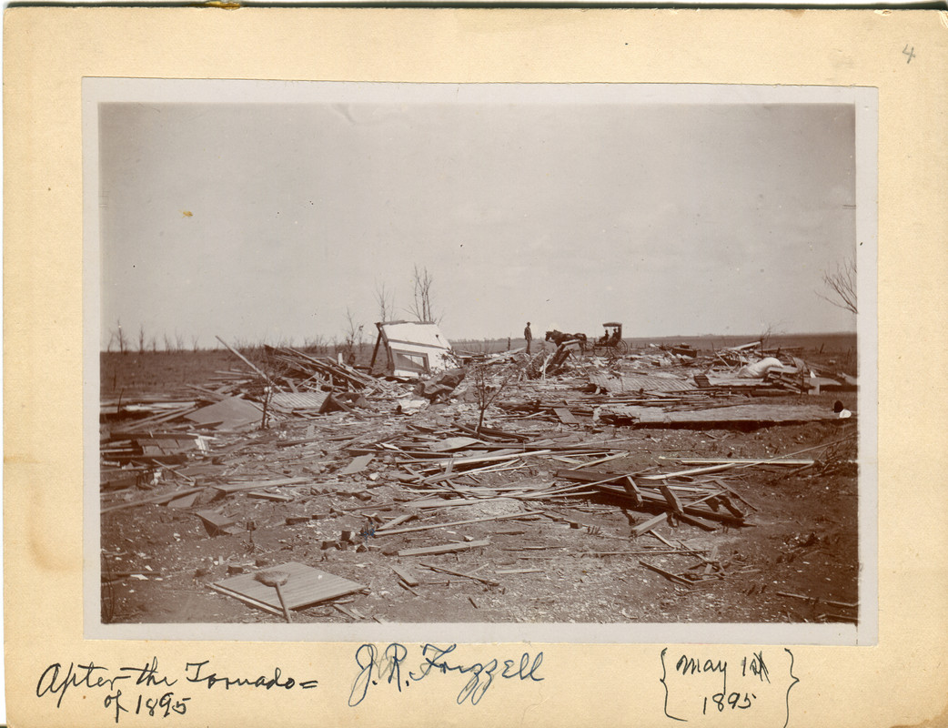
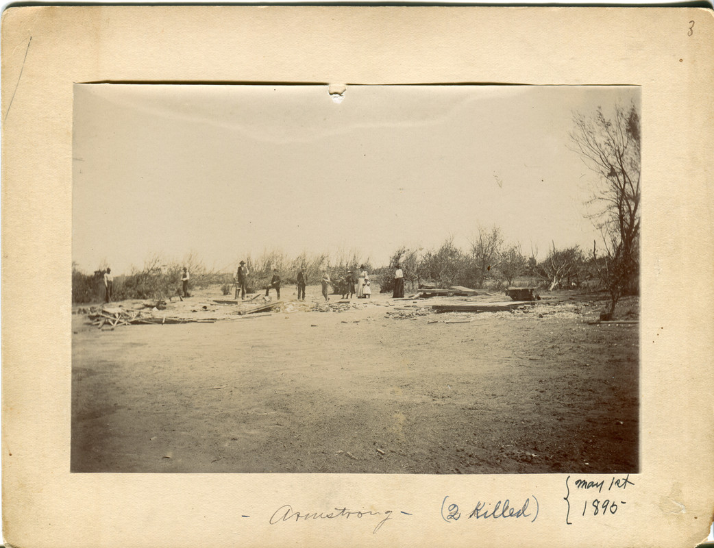
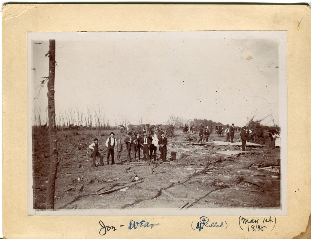
I've posted about this tornado a few times before but the 1895 Halstead, KS tornado is (IMO) one of the few 19th century tornadoes with photographic evidence of F5 damage. Homes and entire farms were swept away with debris being carried over 20 miles in some cases, debris from some of the homes was finely granulated, extensive ground scouring occurred, and trees were debarked. This is the earliest confirmed F5 tornado in Kansas.

Here are some high resolution damage pics I haven't posted before. All photos courtesy of the Harvey County Historical Society and Halstead Historical Society - many thanks for sharing these historic pieces.

edit: Not sure why previews weren't working. Hopefully fixed.
tornado-220061000303.jpg

tornado-120061000302.jpg

halsteadtornado.jpg

halsteadtornado2.jpg

halsteadtornado3.jpg


View attachment halsteadtornado.jpg
View attachment halsteadtornado2.jpg
View attachment halsteadtornado3.jpg
 
Last edited:

TH2002

Member
Sustaining Member
Messages
3,490
Reaction score
5,618
Location
California, United States
Special Affiliations
  1. SKYWARN® Volunteer
Came across some survey information from the 2011 Tuscaloosa tornado regarding the damage in the Holt-Peterson area. This bit pretty much confirms my skepticism that the "trees left standing" home isn't a strong EF5 candidate to begin with:
In the areas east of Holt and north of Brookwood, the tornado remained violent as it crossed Holt Peterson Road just northwest of Clinker Road. In this area, two homes were completely destroyed. One home on a foundation was swept clean from its floor unit, which remained attached to the foundation. Evidence indicated the walls were straight nailed into the floor unit (EF4). Almost all trees were blown down or snapped in the vicinity, as well as in the bottom of a narrow ravine nearly 100 feet below the house.

For one, "trees left standing led to EF4" isn't mentioned anywhere, and closeup photos confirm that the subfloor remained attached to the home's concrete block foundation:
tuscaloosa-damage-holt-peterson-jpg.10539


Another bit I found interesting regarding this home along Recreation Area Rd:
tuscaloosa-damage-eagle-cove-after-jpg.14365

The tornado continued to Holt Lock and Dam Road near its intersection with Recreation Area Road. Numerous mobile homes and several cinder block homes were destroyed in this area (EF3 to EF4). Several fatalities occurred in this area. One home on a foundation was swept completely clean, but there was evidence of minimal anchoring of the floor and walls to the foundation, so a rating of EF4 was assigned. The tornado struck a marina on Holt Lake at the end of Recreation Area Road with EF1 damage to a restaurant as well as numerous boats.

However, this large home SW of Recreation Area Rd remains a mystery. It's not mentioned anywhere in the survey text:
tuscaloosa-damage-rural-home-jpg.14362


Also, I remember pondering in an earlier post that this was just another home swept from its subflooring, but the more I look at this, the more I think I'm mistaken and we're probably looking at a concrete slab with tile flooring. I've heard the TornadoTalk article (behind a paywall) mentions that one well-constructed home was swept away in this area, so this has to be it. I just wish there were ground level photos publicly available, because it's the last missing piece that essentially confirms to me that Tuscaloosa was an EF5 after all.
 

joshoctober16

Member
Messages
157
Reaction score
120
Location
Canada New brunswick
Follow up from above
Non Town/City areas
Possible Home EF5 007a.pngPossible Home EF5 008a.png

and that's all the areas of borderline/possible EF5 Damage...
the next post is about the non borderline EF5 Damage , as in clear EF5 strength hit here it is however unsure if the building quality is right for theses next spots, will post these next
 

joshoctober16

Member
Messages
157
Reaction score
120
Location
Canada New brunswick
Follow up from above
Concord
EF5 Home 001a.png

i was unsure to include this first image but i added it in case (theres one other area to note in tuscaloosa as well like this but its more borderline EF5 damage)
EF5 Home 002a.png
huge area of possible EF5 damage in this spot
 
Messages
2,260
Reaction score
2,862
Location
Missouri
Came across some survey information from the 2011 Tuscaloosa tornado regarding the damage in the Holt-Peterson area. This bit pretty much confirms my skepticism that the "trees left standing" home isn't a strong EF5 candidate to begin with:


For one, "trees left standing led to EF4" isn't mentioned anywhere, and closeup photos confirm that the subfloor remained attached to the home's concrete block foundation:
tuscaloosa-damage-holt-peterson-jpg.10539


Another bit I found interesting regarding this home along Recreation Area Rd:
tuscaloosa-damage-eagle-cove-after-jpg.14365


However, this large home SW of Recreation Area Rd remains a mystery. It's not mentioned anywhere in the survey text:
tuscaloosa-damage-rural-home-jpg.14362


Also, I remember pondering in an earlier post that this was just another home swept from its subflooring, but the more I look at this, the more I think I'm mistaken and we're probably looking at a concrete slab with tile flooring. I've heard the TornadoTalk article (behind a paywall) mentions that one well-constructed home was swept away in this area, so this has to be it. I just wish there were ground level photos publicly available, because it's the last missing piece that essentially confirms to me that Tuscaloosa was an EF5 after all.
That large home not mentioned in the survey text....wonder if they were told to not document it thoroughly, if at all? Maybe some sort of Vilonia-esque situation happened here?
 

joshoctober16

Member
Messages
157
Reaction score
120
Location
Canada New brunswick
Pleasant Grove
EF5 Home 004a.png

and that's i think all the big spots of EF5 damage to note about the Tuscaloosa tornado.
other spots are not on homes, or poorly built for sure as far as i know unless i missed one.

so look away at any of these spots more up close if you can i guess...
 
Logo 468x120
Top