
Navigation
Install the app
How to install the app on iOS
Follow along with the video below to see how to install our site as a web app on your home screen.

Note: this_feature_currently_requires_accessing_site_using_safari
More options
-
Welcome to TalkWeather! We see you lurking around TalkWeather! Take the extra step and join us today to view attachments, see less ads and maybe even join the discussion. CLICK TO JOIN TALKWEATHER -
 April 2024 Weather Video of the Month Post your nominations now!
You are using an out of date browser. It may not display this or other websites correctly.
You should upgrade or use an alternative browser.
You should upgrade or use an alternative browser.
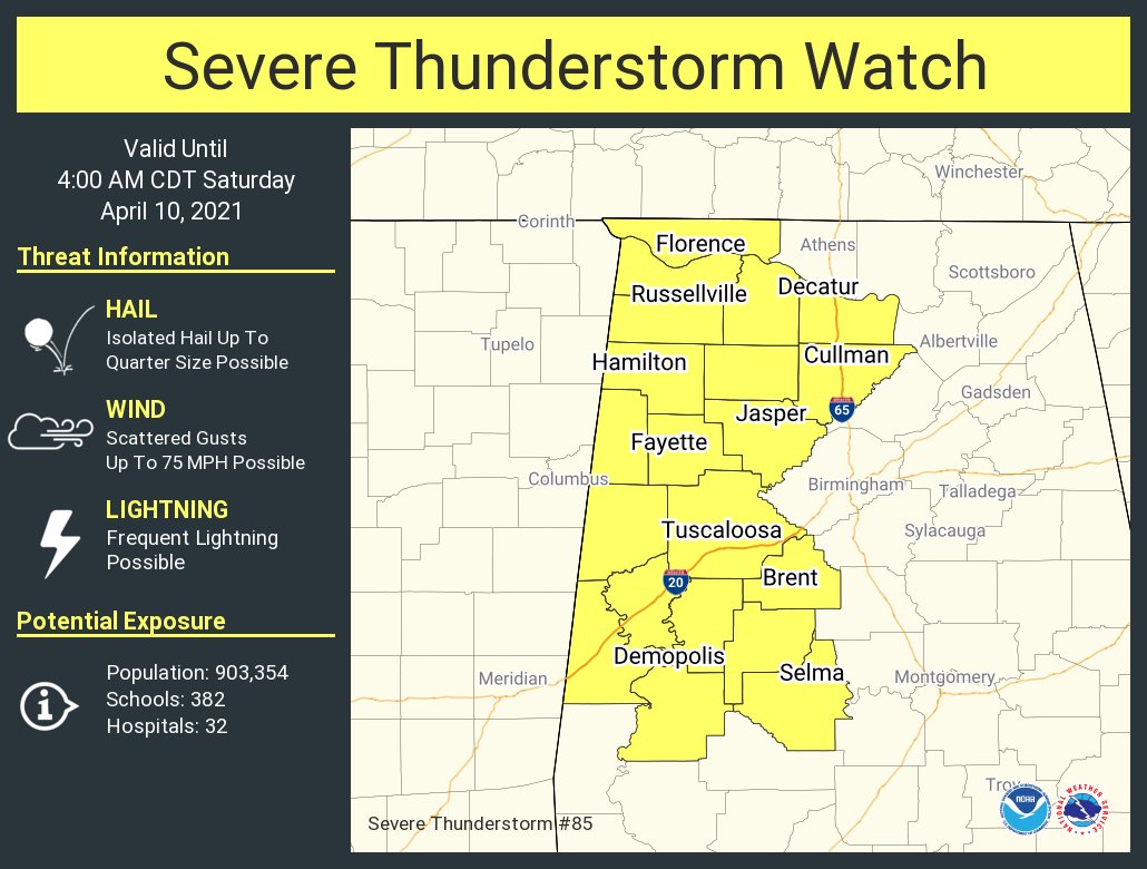
Severe WX Severe Weather Threat April 7-10, 2021
- Thread starter TH2002
- Start date
WhirlingWx
Member
It's probably lifted for the time being, because Adair can't really find any damage from where the area of rotation had just crossed.
- Thread starter
- #123
- Messages
- 3,490
- Reaction score
- 5,621
- Location
- California, United States
- Special Affiliations
- SKYWARN® Volunteer
Still a very well defined hook echo

TornadoFan
Member
I think it's down again. The hook looks classic.
- Moderator
- #125

- Thread starter
- #126
- Messages
- 3,490
- Reaction score
- 5,621
- Location
- California, United States
- Special Affiliations
- SKYWARN® Volunteer
Yeah that's a definite debris ball on reflectivity. Velocity and CC signatures look unimpressive though that's likely because the tornado is so close to the NWS Jackson radar site

Equus
Member
Line near GWX is warned for 90mph winds and velocity is showing winds that high at very low levels; not looking forward to that
David in SW Blount
Member
NWS Birmingham has my location in a marginal risk in the morning; whereas, SPC says enhanced. Pretty big discrepancy!
Bama Ravens
Member
Is the line further east than it was anticipated to be by this time, or is the line in east MS not the main line?
Bama Ravens
Member
Yeah, they clearly have a big difference of opinion for this event.NWS Birmingham has my location in a marginal risk in the morning; whereas, SPC says enhanced. Pretty big discrepancy!
David in SW Blount
Member
Spann just posted that it's not the main one. Another one crosses the state from 4-10AM.Is the line further east than it was anticipated to be by this time, or is the line in east MS not the main line?
I was wrong. It is still west of here expected to move east overnight but this was the tail end of the current system stretching into MS.It may not look like much but the dry line is starting to fire on the west side of I-35 in central Texas.
*enhanced for clarity of the thunderheads.View attachment 8519View attachment 8520View attachment 8521View attachment 8522
They will explode after they cross I-35 and the imagnary bubble over the Austin metro area. This bubble has been documented by weather enthusiasts for years.
Gail
Member
Multiple rounds tonight. This one now and another in the middle of the night.Is the line further east than it was anticipated to be by this time, or is the line in east MS not the main line?
I'm looking at this system stretching from NE MS all the way into TX and it is twisting and turning like mad while the dry line and 36 degree dew points are still attaching to a front and moving west. It's going to be a long night.Multiple rounds tonight. This one now and another in the middle of the night.
Bama Ravens
Member
Fantastic.Spann just posted that it's not the main one. Another one crosses the state from 4-10AM.
Bama Ravens
Member
Bama Ravens
Member
Looks like what will be our second/final line is getting going back in eastern Oklahoma/northeast Texas.
Dewpoints in the 50sNWS Birmingham has my location in a marginal risk in the morning; whereas, SPC says enhanced. Pretty big discrepancy!
")
David in SW Blount
Member
I'll take marginal!Dewpoints in the 50s
