Welcome to TalkWeather!
We see you lurking around TalkWeather! Take the extra step and join us today to view attachments, see less ads and maybe even join the discussion.
CLICK TO JOIN TALKWEATHER
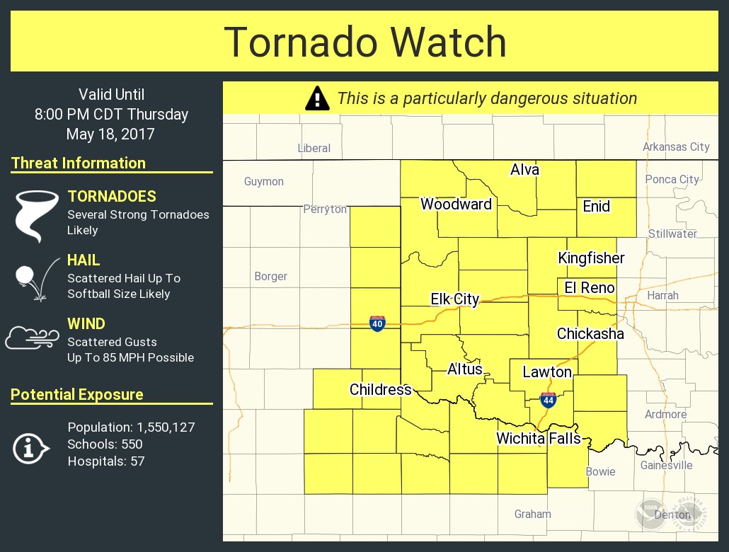
URGENT - IMMEDIATE BROADCAST REQUESTED
Tornado Watch Number 235
NWS Storm Prediction Center Norman OK
115 PM CDT Thu May 18 2017
The NWS Storm Prediction Center has issued a
* Tornado Watch for portions of
western Oklahoma
western north Texas
* Effective this Thursday afternoon and evening from 115 PM until
800 PM CDT.
...THIS IS A PARTICULARLY DANGEROUS SITUATION...
* Primary threats include...
Several tornadoes and a few intense tornadoes likely
Scattered large hail likely with isolated very large hail events
to 4 inches in diameter possible
Scattered damaging winds and isolated significant gusts to 80
mph possible
SUMMARY...Thunderstorms are forecast to develop/increase rapidly
over the next 1-2 hours across eastern portions of the Texas
Panhandle and into western Oklahoma and western north Texas,
spreading northeastward with time. Multiple rounds of storm
redevelopment will be possible over western parts of the watch. In
addition to the risk for very large/damaging hail and locally
damaging winds, tornadoes -- a couple likely to be
significant/intense -- are expected.
The tornado watch area is approximately along and 75 statute miles
east and west of a line from 15 miles west northwest of Alva OK to
75 miles west southwest of Wichita Falls TX. For a complete
depiction of the watch see the associated watch outline update
(WOUS64 KWNS WOU5).
Idk. I'd hesitate to judge anything about later because one storm fired in the enhanced risk area. It's trying to get its act together it looks like. Could be a bad sign if it's not an indication of widespread early convection.
Yeah, see. If we don't get a bunch of cells popping right away, this is just making me more worried. Look how fast that storm organized outside of the main risk area.
URGENT - IMMEDIATE BROADCAST REQUESTED
Tornado Watch Number 236
NWS Storm Prediction Center Norman OK
155 PM CDT Thu May 18 2017
The NWS Storm Prediction Center has issued a
* Tornado Watch for portions of
portions of northern and central Texas
* Effective this Thursday afternoon and evening from 155 PM until
1000 PM CDT.
* Primary threats include...
A couple tornadoes possible
Scattered large hail and isolated very large hail events to 4
inches in diameter possible
Scattered damaging wind gusts to 70 mph possible
SUMMARY...Strong/severe thunderstorms are forecast to develop in the
next hour or so across portions of northern and central Texas,
expanding in coverage as they spread eastward/northeastward through
the afternoon and evening hours. Along with risk for a couple of
tornadoes, very large/destructive hail and damaging wind gusts will
be likely with the strongest storms/bands of storms.
The tornado watch area is approximately along and 65 statute miles
north and south of a line from 70 miles west of Abilene TX to 45
miles southeast of Fort Worth TX. For a complete depiction of the
watch see the associated watch outline update (WOUS64 KWNS WOU6).
That's a really tight couplet. Wow. I hope this isn't a sign of things to come. Looks like another supercell is developing to its southwest too. Maybe stuff trying to happen further north?
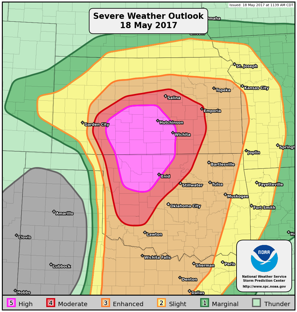
SUMMARY...Severe thunderstorms will develop across parts of southern
and central Kansas this afternoon and evening, with an attendant
threat of tornadoes (some of which may be strong), very large hail,
and damaging winds. A PDS Tornado Watch will likely be issued within
the next hour or two.
DISCUSSION...Surface analyses indicate a warm front is slowly
advancing northward across southern Kansas this afternoon. To the
south of this front, ample boundary-layer heating has resulted in
considerable mixed-layer buoyancy, with CAPE values upwards of
2500-3000 J/kg. As forcing for ascent continues to increase over the
region, low-level moisture will continue to stream north/northwest,
promoting a further increase in buoyancy over southern Kansas. With
850-700mb southerly flow strengthening during the late
afternoon/evening, warm advection near/south of the warm front will
lead to a blossoming of convection over the region. Indeed, current
visible satellite data show a developing cumulus field beneath a
higher-level canopy. Severe thunderstorms will likely develop out of
this cumulus field as it continues to advance north/northwest ahead
of the dry line and south of the warm front.
Cells near the warm front will interact with more backed low-level
flow, enhancing storm-relative helicity. In turn, with continued
north/northwestward transport of rich boundary-layer moisture, the
potential exists for a few discrete cells with organized/strong
low-level mesocyclones. A tornado threat would likely evolve, with
the potential for a few stronger tornadoes, considering the ample
low-level helicity. Steep mid-level lapse rates and considerable
effective shear will encourage a threat of very large hail.
Moreover, somewhat straight mid-level hodographs could yield upscale
growth through the evening. While this would reduce the tornado
threat some, merging cold pools (aided by dry air aloft) would offer
the potential for a few significant severe gusts. In turn, with the
potential for all higher-end severe hazards, a PDS Tornado Watch
will likely be issued within the next hour or two.
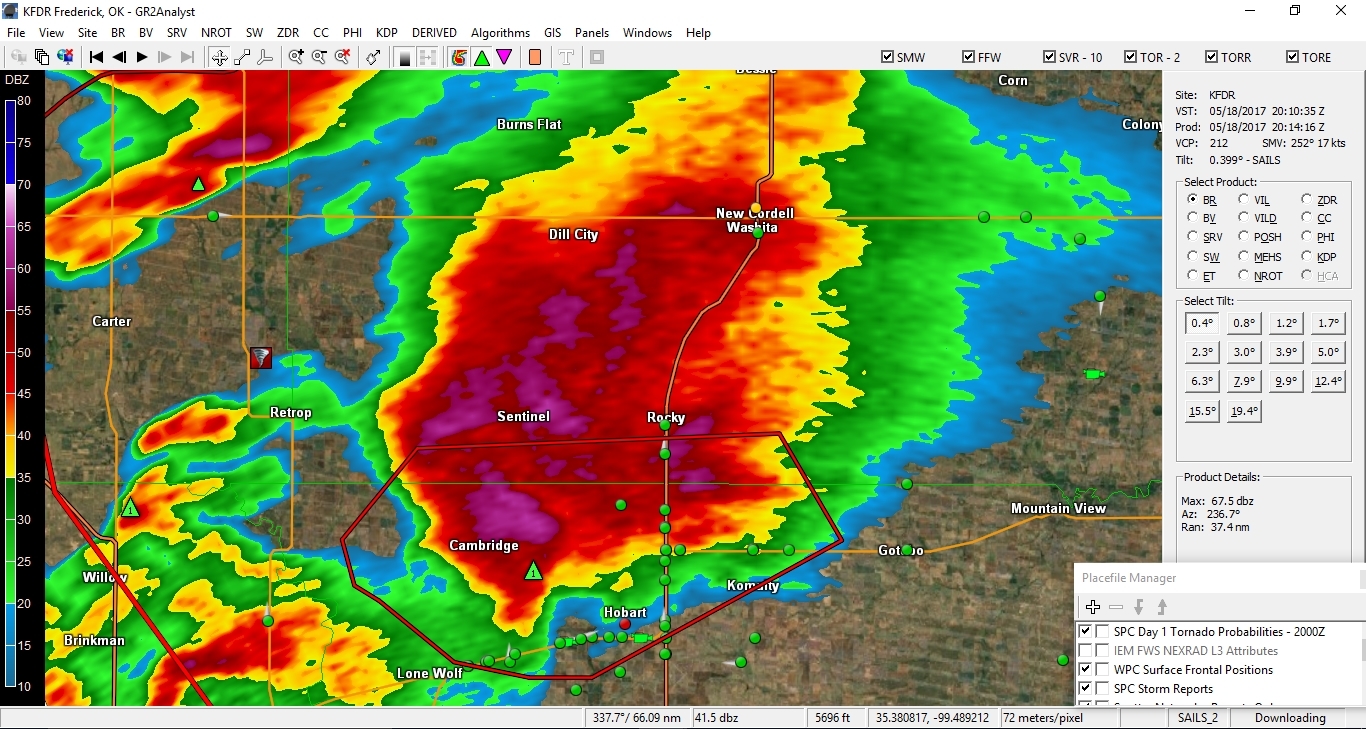
Western OK dominant cell has become a HP mess. The storm in Texas is p isolated and looks to be tightening up. Ric burney is on it, but chasertv is being stupid and i can't pull up his livestream. If anybody has his stream, please post!
Edit: i mean seriously, this thing looks more like a developing tropical storm than a supercell:
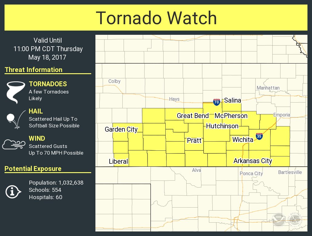
New tornado watch in south Kansas, but they didn't go PDS, even though this is in the high/moderate risk area. Of course, may be the right call not to go PDS, as storms may be clustered.
This site uses cookies to help personalise content, tailor your experience and to keep you logged in if you register.
By continuing to use this site, you are consenting to our use of cookies.
We appreciate you being a TalkWeather member. We encourage you to become one of Sustaining Members at $5 a month. Sustaining members also recieve an ad-free experience and a special profile title and help provide funding for additional servers for large winter or severe weather events. Upgrade Now